METAR & TAF 1M2
1M2 does not publish a METAR.
Showing the nearest reporting station: KGWO (GREENWOOD-LEFLORE) · 30.0 NM away. Conditions at 1M2 may differ.
METAR · KGWO
Observed 12:53Z
KGWO 271253Z AUTO 00000KT 10SM CLR 27/24 A2998 RMK AO2 SLP148 T02670244
- Wind
- 000° @ 0 kt
- Visibility
- 10 SM
- Temp / Dew
- 27°C / 24°C
- Altimeter
- 29.98 inHg
- Clouds
- CLR
- Density alt
- 1,502 ft
- Ceiling
- Unlimited
- Rules
- VFR
Airport info & contacts
Manager on record, flight service, ARTCC, attendance schedule and pattern altitude — published by the FAA and refreshed every 28 days.
Location
- From city
- 3 NM SW
- VFR sectional
- MEMPHIS
- ARTCC
- ZME · MEMPHIS
- NOTAM facility
- GWO (NOTAM-D)
Airport manager
- Name
- ROB HEFLIN
- Phone
- 662-962-4840
- Address
- 102 W JACKSON ST, BELZONI MS 39038
Flight service · Hours
- FSS GWO
- GREENWOOD1-800-WX-BRIEF
- Attendance
- Unattended
Frequencies
Tap any row to copy the frequency to your clipboard.
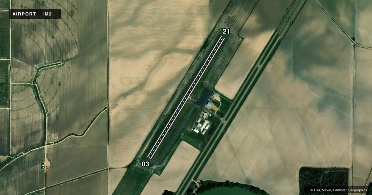
Runways & pattern
Full pagePattern entry · RWY 03
LEFT TRAFFICRunway end performance
| End | TORA | TODA | ASDA | LDA | VGSI | Approach lights | Obstruction |
|---|---|---|---|---|---|---|---|
| 03 | — | — | — | — | PAPI 2-box left(3°) | — | 28', pline, 1400' from thr, 25' R of cntrln, slope 42 |
| 21 | — | — | — | — | PAPI 2-box left(3°) | — | — |
Declared distances in feet. TORA = takeoff run available, TODA = takeoff distance, ASDA = accelerate-stop, LDA = landing distance.
Airport sketch
Runways drawn to scale from FAA survey coordinates, rendered over satellite imagery. Not for navigation.
Approaches & charts
Services on the field
Fuel grades, oxygen, maintenance, ramp storage and lighting — as declared to the FAA by the airport operator.
Fuel & services
- Fuel
- 100LL
- Oxygen (bottled)
- Not available
- Oxygen (bulk)
- Not available
- Airframe repair
- Not available
- Power plant repair
- Not available
- Other services
- AGRI
Ramp & ground
- Transient storage
- Tie-down
- Landing fee
- No fee published
- Customs
- Not available
- Lighting schedule
- SEE RMK
- Beacon schedule
- SS-SR
- Beacon
- White / Green (civil land)(WG)
- Wind indicator
- Lighted
- Segmented circle
- No
Fuel & FBOs
Cheapest 100LL and Jet A on the field and nearby. Always confirm with the FBO before taxi.
Airport notes
Surface conditions, obstructions, local procedures, lighting outages and other notes published with each FAA cycle.
General notes
- FOR CD CTC MEMPHIS ARTCC AT 901-368-8453/8449.
Lighting notes
- ACTVT MIRL 03/21 - CTAF.
Fuel notes
- 100LLSELF SVC AVBL 24 HRS VIA CREDIT CARD.
Other notes
- THIS AIRPORT HAS BEEN SURVEYED BY THE NATIONAL GEODETIC SURVEY.
- PILOTS MUST PRVD TIEDOWN ROPES.
VFR map & nearby airports
VFR sectional. Tap any ICAO chip to open that airport.
Key facts · 1M2
Answer card- ICAO
- 1M2
- Name
- BELZONI MUNI
- Location
- BELZONI, MISSISSIPPI
- Elevation
- 110 ft MSL
- Traffic pattern altitude
- 1,110 ft MSL (1,000 AGL)
- Control tower
- Non-towered (use CTAF)
- Total runways
- 1
- Longest runway
- 03/21 · 3,000 ft
- Published ILS approaches
- 0
- Published frequencies
- 1
- Magnetic variation
- 3°
- Current flight rules
- VFR
- Current wind
- 000° at 0 kt
- Favored runway now
- –
Belzoni Muni sits in Belzoni, Mississippi at 110 ft MSL. It has one runway, 03/21, which is 3,000 ft long and paved with asphalt. The field is non-towered. CTAF is 122.9. The published pattern altitude is not listed, so use the standard 1,000 ft AGL for light piston traffic unless the current Chart Supplement says otherwise. That puts the pattern at 1,110 ft MSL here.
There are no ILS approaches published for 1M2. The runway lights on 03 and 21 are medium intensity. They are activated by CTAF. Self-serve 100LL is available 24 hours by credit card. No on-field FBOs are listed, so plan on coordinating directly with the airport operator if you need local support. Pilots should also bring their own tiedown ropes.
For a first-time arrival, the main things to plan for are a short local runway, a non-towered pattern and the lack of published ILS. If you need IFR clearance, contact Memphis ARTCC at the published phone numbers before departure. Check the current FAA Chart Supplement for any changes before you go.