METAR & TAF 19M
19M does not publish a METAR.
Showing the nearest reporting station: KGWO (GREENWOOD-LEFLORE) · 22.3 NM away. Conditions at 19M may differ.
METAR · KGWO
Observed 11:53Z
KGWO 271153Z AUTO 00000KT 10SM CLR 25/24 A2996 RMK AO2 SLP144 T02500239 10267 20244 53013
- Wind
- 000° @ 0 kt
- Visibility
- 10 SM
- Temp / Dew
- 25°C / 24°C
- Altimeter
- 29.96 inHg
- Clouds
- CLR
- Density alt
- 1,572 ft
- Ceiling
- Unlimited
- Rules
- VFR
Airport info & contacts
Manager on record, flight service, ARTCC, attendance schedule and pattern altitude — published by the FAA and refreshed every 28 days.
Location
- From city
- 2 NM NE
- VFR sectional
- MEMPHIS
- ARTCC
- ZME · MEMPHIS
- NOTAM facility
- GWO (NOTAM-D)
Airport manager
- Name
- MAYOR PERCY WASHINGTON
- Phone
- 662-834-1261
- Address
- PO BOX 455, 112 SPRING ST, LEXINGTON MS 39095
Flight service · Hours
- FSS GWO
- GREENWOOD1-800-WX-BRIEF
- Attendance
- Unattended
Frequencies
Tap any row to copy the frequency to your clipboard.
Runways & pattern
Full pagePattern entry · RWY 01
LEFT TRAFFICRunway end performance
| End | TORA | TODA | ASDA | LDA | VGSI | Approach lights | Obstruction |
|---|---|---|---|---|---|---|---|
| 01 | — | — | — | — | PAPI 2-box left(3°) | — | 32', trees, 1365' from thr, 50' R of cntrln, slope 36 |
| 19 | — | — | — | — | PAPI 2-box left(4°) | — | 41', tree, 1200' from thr, 60' R of cntrln, slope 24 |
Declared distances in feet. TORA = takeoff run available, TODA = takeoff distance, ASDA = accelerate-stop, LDA = landing distance.
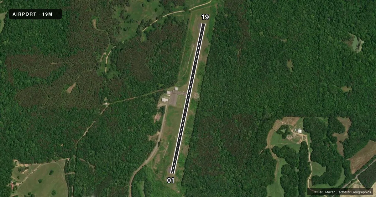
Airport sketch
Runways drawn to scale from FAA survey coordinates, rendered over satellite imagery. Not for navigation.
Approaches & charts
Services on the field
Fuel grades, oxygen, maintenance, ramp storage and lighting — as declared to the FAA by the airport operator.
Fuel & services
- Fuel
- Not available
- Oxygen (bottled)
- Not available
- Oxygen (bulk)
- Not available
- Airframe repair
- Not available
- Power plant repair
- Not available
Ramp & ground
- Transient storage
- Tie-down
- Landing fee
- No fee published
- Customs
- Not available
- Lighting schedule
- SS-SR
- Beacon schedule
- SS-SR
- Beacon
- White / Green (civil land)(WG)
- Wind indicator
- Lighted
- Segmented circle
- Yes
Fuel & FBOs
Cheapest 100LL and Jet A on the field and nearby. Always confirm with the FBO before taxi.
Airport notes
Surface conditions, obstructions, local procedures, lighting outages and other notes published with each FAA cycle.
General notes
- FOR CD CTC MEMPHIS ARTCC AT 901-368-8453/8449.
Other notes
- PILOTS MUST PRVD THEIR OWN TIEDOWN ROPES.
- MANAGERPOLICE DEPT 662-834-3508.
VFR map & nearby airports
VFR sectional. Tap any ICAO chip to open that airport.
Key facts · 19M
Answer card- ICAO
- 19M
- Name
- C A MOORE
- Location
- LEXINGTON, MISSISSIPPI
- Elevation
- 340 ft MSL
- Traffic pattern altitude
- 1,340 ft MSL (1,000 AGL)
- Control tower
- Non-towered (use CTAF)
- Total runways
- 1
- Longest runway
- 01/19 · 3,199 ft
- Published ILS approaches
- 0
- Published frequencies
- 1
- Magnetic variation
- 2°
- Current flight rules
- VFR
- Current wind
- 000° at 0 kt
- Favored runway now
- –
C A Moore Airport (19M) sits in Lexington, Mississippi. The field elevation is 340 ft MSL. It has one runway. Runway 01/19 is 3,199 ft long with an asphalt surface. There is no control tower. CTAF is 122.9.
No ILS approaches are published here. The pattern altitude is not published, so use the standard 1,000 ft AGL pattern unless current published guidance says otherwise. That puts the traffic pattern at 1,340 ft MSL based on the field elevation. Verify before you fly. The published remarks also say to contact Memphis ARTCC for clearance delivery. The Chart Supplement gives the phone numbers. Pilots should also bring their own tiedown ropes. The police department phone number is listed in the remarks too.
There are no on-field FBOs listed in the facts for 19M. Plan accordingly. Call the airport operator or the field directly before arrival if you need fuel or other services. For a first visit, the main things to watch are the non-towered pattern, the single 3,199 ft runway and the lack of published ILS support. Check the current Chart Supplement for any noise or local operating notes before flying in.