METAR & TAF KCRT
KCRT does not publish a METAR.
Showing the nearest reporting station: KBQP (MOREHOUSE MEML) · 25.4 NM away. Conditions at KCRT may differ.
METAR · KBQP
Observed 13:10Z
KBQP 271310Z AUTO 00000KT OVC002 28/23 A3001 RMK AO2 T02790231 PWINO
- Wind
- 000° @ 0 kt
- Visibility
- —
- Temp / Dew
- 28°C / 23°C
- Altimeter
- 30.01 inHg
- Clouds
- OVC
- Density alt
- 1,676 ft
- Ceiling
- 200 ft AGL
- Rules
- LIFR
Airport info & contacts
Manager on record, flight service, ARTCC, attendance schedule and pattern altitude — published by the FAA and refreshed every 28 days.
Location
- From city
- 5 NM NE
- VFR sectional
- MEMPHIS
- ARTCC
- ZME · MEMPHIS
- NOTAM facility
- JBR (NOTAM-D)
Airport manager
- Name
- TODD FREEMAN
- Phone
- 870-304-6361
- Address
- PO BOX 637, CROSSETT AR 71635
Flight service · Hours
- FSS JBR
- JONESBORO1-800-WX-BRIEF
- Attendance
- MON-FRI · IREG
Frequencies
Tap any row to copy the frequency to your clipboard.
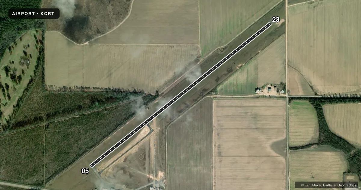
Runways & pattern
Full pagePattern entry · RWY 05
LEFT TRAFFICRunway end performance
| End | TORA | TODA | ASDA | LDA | VGSI | Approach lights | Obstruction |
|---|---|---|---|---|---|---|---|
| 05 | — | — | — | — | PAPI 2-box left(3.25°) | — | 35', trees, 750' from thr, 315' R of cntrln, slope 15 |
| 23 | — | — | — | — | PAPI 2-box left(3.25°) | — | — |
Declared distances in feet. TORA = takeoff run available, TODA = takeoff distance, ASDA = accelerate-stop, LDA = landing distance.
Airport sketch
Runways drawn to scale from FAA survey coordinates, rendered over satellite imagery. Not for navigation.
Approaches & charts
Services on the field
Fuel grades, oxygen, maintenance, ramp storage and lighting — as declared to the FAA by the airport operator.
Fuel & services
- Fuel
- 100LLA
- Oxygen (bottled)
- Not available
- Oxygen (bulk)
- Not available
- Other services
- AGRI
Ramp & ground
- Transient storage
- Tie-down
- Hangar
- Landing fee
- Yes
- Customs
- Not available
- Lighting schedule
- SS-SR
- Beacon schedule
- SS-SR
- Beacon
- White / Green (civil land)(WG)
- Wind indicator
- Lighted
- Segmented circle
- Yes
Fuel & FBOs
Cheapest 100LL and Jet A on the field and nearby. Always confirm with the FBO before taxi.
Airport notes
Surface conditions, obstructions, local procedures, lighting outages and other notes published with each FAA cycle.
General notes
- MIDFIELD TWY CLSD TO ACFT OVER 6000 LBS.
- FOR CD CTC MEMPHIS ARTCC AT 901-368-8453/8449.
Fuel notes
- 100LLSELF SERVE FUEL AVBL 24 HRS WITH CREDIT CARD. ASSISTANCE AVBL IF NEEDED
Approach & departure obstructions
- 05PAPI NIGHTTIME ONLY
- 23PAPI NIGHTTIME ONLY
Other notes
- FEE CHRGD ACFT GTR THAN 8645 LBS UNLESS FUEL PURCHASED.
VFR map & nearby airports
VFR sectional. Tap any ICAO chip to open that airport.
Key facts · KCRT
Answer card- ICAO
- KCRT
- Name
- Z M JACK STELL FLD
- Location
- CROSSETT, ARKANSAS
- Elevation
- 183.5 ft MSL
- Traffic pattern altitude
- 1,183.5 ft MSL (1,000 AGL)
- Control tower
- Non-towered (use CTAF)
- Total runways
- 1
- Longest runway
- 05/23 · 5,010 ft
- Published ILS approaches
- 0
- Published frequencies
- 2
- Magnetic variation
- 2°
- Current flight rules
- LIFR
- Current wind
- 000° at 0 kt
- Favored runway now
- –
Z M Jack Stell Fld sits in Crossett, Arkansas. Field elevation is 183.5 ft MSL. The airport has one runway, 05/23, which is 5,010 ft long on asphalt. There is no control tower. CTAF and UNICOM are both 122.8. No ILS approaches are published here, so plan with the current chart and your own arrival setup.
Pattern altitude is not published. Use 1,000 ft AGL for light piston operations unless local guidance says otherwise. The field is served by Crossett Airport Commission on the field. It carries 100LL and Jet A. Self-serve 100LL is available 24 hours with a credit card. Assistance is available if needed.
A few remarks matter for planning. The PAPI is available at night only on both runway ends. The midfield taxiway is closed to aircraft over 6,000 lb. A landing fee applies to aircraft over 8,645 lb unless fuel is purchased. For clearance delivery, contact Memphis ARTCC before departure. This is a non-towered field, so expect standard self-announce traffic and keep an eye on local traffic flow. If you are bringing a heavier aircraft, check the taxiway and fee notes before you go.