METAR & TAF 06M
06M does not publish a METAR.
Showing the nearest reporting station: KSTF (GEORGE M BRYAN) · 24.0 NM away. Conditions at 06M may differ.
METAR · KSTF
Observed 02:15Z
KSTF 270215Z AUTO 00000KT 10SM BKN055 28/28 A2991 RMK AO2
- Wind
- 000° @ 0 kt
- Visibility
- 10 SM
- Temp / Dew
- 28°C / 28°C
- Altimeter
- 29.91 inHg
- Clouds
- BKN
- Density alt
- 2,130 ft
- Ceiling
- 5,500 ft AGL
- Rules
- VFR
Airport info & contacts
Manager on record, flight service, ARTCC, attendance schedule and pattern altitude — published by the FAA and refreshed every 28 days.
Location
- From city
- 2 NM W
- VFR sectional
- MEMPHIS
- ARTCC
- ZME · MEMPHIS
- NOTAM facility
- GWO (NOTAM-D)
Airport manager
- Name
- LAMAR DUMAS, MAYOR
- Phone
- 662-258-2291
- Address
- 390 CLARK AVE, 102 E CLARK AVE, EUPORA MS 39744
Flight service · Hours
- FSS GWO
- GREENWOOD1-800-WX-BRIEF
- Attendance
- Unattended
Frequencies
Tap any row to copy the frequency to your clipboard.
Runways & pattern
Full pagePattern entry · RWY 14
LEFT TRAFFICRunway end performance
| End | TORA | TODA | ASDA | LDA | VGSI | Approach lights | Obstruction |
|---|---|---|---|---|---|---|---|
| 14 | — | — | — | — | PAPI 2-box left(3°) | — | 40', tree, 1000' from thr, 0' R of cntrln, slope 20 |
| 32 | — | — | — | — | PAPI 2-box left(3°) | — | — |
Declared distances in feet. TORA = takeoff run available, TODA = takeoff distance, ASDA = accelerate-stop, LDA = landing distance.
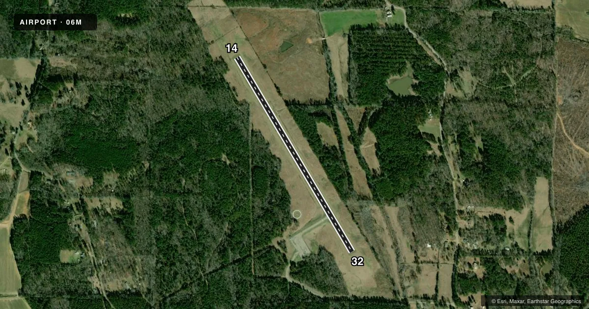
Airport sketch
Runways drawn to scale from FAA survey coordinates, rendered over satellite imagery. Not for navigation.
Approaches & charts
Services on the field
Fuel grades, oxygen, maintenance, ramp storage and lighting — as declared to the FAA by the airport operator.
Fuel & services
- Fuel
- Not available
- Oxygen (bottled)
- Not available
- Oxygen (bulk)
- Not available
- Airframe repair
- Not available
- Power plant repair
- Not available
- Other services
- AGRI
Ramp & ground
- Transient storage
- Tie-down
- Landing fee
- No fee published
- Customs
- Not available
- Lighting schedule
- SEE RMK
- Beacon schedule
- SS-SR
- Beacon
- White / Green (civil land)(WG)
- Wind indicator
- Lighted
- Segmented circle
- Yes
Fuel & FBOs
Cheapest 100LL and Jet A on the field and nearby. Always confirm with the FBO before taxi.
Airport notes
Surface conditions, obstructions, local procedures, lighting outages and other notes published with each FAA cycle.
General notes
- FOR CD CTC MEMPHIS ARTCC AT 901-368-8453/8449.
Lighting notes
- ACTVT PAPI RWY 14 & 32; MIRL RWY 14/32 - CTAF.
Other notes
- PILOTS MUST PRVD THEIR OWN TIEDOWN ROPES.
VFR map & nearby airports
VFR sectional. Tap any ICAO chip to open that airport.
Key facts · 06M
Answer card- ICAO
- 06M
- Name
- EUPORA
- Location
- EUPORA, MISSISSIPPI
- Elevation
- 450 ft MSL
- Traffic pattern altitude
- 1,450 ft MSL (1,000 AGL)
- Control tower
- Non-towered (use CTAF)
- Total runways
- 1
- Longest runway
- 14/32 · 3,000 ft
- Published ILS approaches
- 0
- Published frequencies
- 1
- Magnetic variation
- 2°
- Current flight rules
- VFR
- Current wind
- 000° at 0 kt
- Favored runway now
- –
Eupora Airport is in Eupora, Mississippi. The field elevation is 450 ft MSL. It has one runway. Runway 14/32 is 3,000 ft asphalt, so plan your takeoff and landing distances with that length in mind. There is no control tower. CTAF is 122.9.
No ILS approaches are published here. The pattern altitude is not published in the facts, so use the standard 1,000 ft AGL for light piston traffic unless the current FAA Chart Supplement says otherwise. The published remarks also note that the PAPI and medium intensity runway lights on 14 and 32 are activated by CTAF. That is useful if you are arriving near dusk or after dark. For clearance delivery, Memphis ARTCC is the published contact point.
There are no on-field FBOs listed in the facts. Plan ahead for services before you go. Pilots also need to bring their own tiedown ropes. If you are used to busier airports, this is a simple field with limited published instrument support, so check the current FAA Chart Supplement before departure and again before arrival.