METAR & TAF KTXK
Current METAR
Observed 12:53Z
KTXK 271253Z 23008KT 10SM CLR 29/23 A2998 RMK AO2 SLP145 T02940233
- Wind
- 230° @ 8 kt
- Visibility
- 10 SM
- Temp / Dew
- 29°C / 23°C
- Altimeter
- 29.98 inHg
- Clouds
- CLR
- Density alt
- 2,089 ft
- Ceiling
- Unlimited
- Rules
- VFR
Airport info & contacts
Manager on record, flight service, ARTCC, attendance schedule and pattern altitude — published by the FAA and refreshed every 28 days.
Location
- From city
- 3 NM NE
- VFR sectional
- MEMPHIS
- Pattern altitude
- 1,200 ft AGL · 1,590 ft MSL
- ARTCC
- ZFW · FORT WORTH
- NOTAM facility
- TXK (NOTAM-D)
Airport manager
- Name
- FERDINAND PAUL MEHRLICH III, ACE
- Phone
- 870-774-2171
- Address
- 201 AIRPORT DR, TEXARKANA AR 71854
Flight service · Hours
- FSS JBR
- JONESBORO1-800-WX-BRIEF
- Attendance
- 0600-2200
Frequencies
Tap any row to copy the frequency to your clipboard.
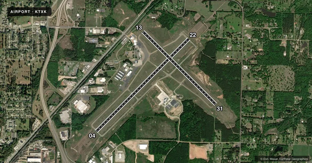
Runways & pattern
Full pagePattern entry · RWY 22
LEFT TRAFFIC| Runway | Heading (°M) | Length | Surface | Traffic |
|---|---|---|---|---|
| 04/22Favored | 40° / 220° | 6,602 ft | ASPH | Standard L |
| 13/31 | 130° / 310° | 5,200 ft | ASPH | Standard L |
Runway end performance
| End | TORA | TODA | ASDA | LDA | VGSI | Approach lights | Obstruction |
|---|---|---|---|---|---|---|---|
| 04 | 6,602' | 6,602' | 6,602' | 6,602' | VASI 4-box left(3°) | — | 31', trees, 263' from thr, 505' R of cntrln, slope 2 |
| 22 | 6,602' | 6,602' | 6,602' | 6,602' | — | MALSR | 17', trees, 358' from thr, 511' R of cntrln, slope 9 |
| 13 | 5,200' | 5,200' | 5,200' | 4,559' | PAPI 4-box left(3°) | — | 15', rr, 350' from thr, 0' R of cntrln, slope 22 |
| 31 | 5,200' | 5,200' | 4,559' | 4,559' | — | — | 40', tree, 750' from thr, 300' R of cntrln, slope 20 |
Declared distances in feet. TORA = takeoff run available, TODA = takeoff distance, ASDA = accelerate-stop, LDA = landing distance.
Airport sketch
Runways drawn to scale from FAA survey coordinates, rendered over satellite imagery. Not for navigation.
Approaches & charts
ILS · 1
Services on the field
Fuel grades, oxygen, maintenance, ramp storage and lighting — as declared to the FAA by the airport operator.
Fuel & services
- Fuel
- 100LLA
- Oxygen (bottled)
- High pressure
- Airframe repair
- Major
- Power plant repair
- Major
- Other services
- AFRT,CHTR,INSTR,RNTL,SALES
Ramp & ground
- Transient storage
- Tie-down
- Hangar
- Landing fee
- Yes
- Customs
- Not available
- Lighting schedule
- SEE RMK
- Beacon schedule
- SS-SR
- Beacon
- White / Green (civil land)(WG)
- Wind indicator
- Lighted
- Segmented circle
- Yes
Fuel & FBOs
Cheapest 100LL and Jet A on the field and nearby. Always confirm with the FBO before taxi.
Airport notes
Surface conditions, obstructions, local procedures, lighting outages and other notes published with each FAA cycle.
General notes
- DEER ON & INVOF ARPT.
- FOR CD IF UNA TO CTC ON FSS FREQ, CTC FORT WORTH ARTCC AT 817-858-7584.
- BIRDS ON & INVOF ARPT.
Lighting notes
- WHEN ATCT CLSD ACTVT MALSR RWY 22; HIRL RWY 04/22; MIRL RWY 13/31 - CTAF.
Runway surface & condition
- 04/22PCR VALUE: 459/F/B/X/T
- 13/31PCR VALUE: 180/F/C/Y/U
Other notes
- OWNERTEXARKANA AIRPORT AUTHORITY
VFR map & nearby airports
VFR sectional. Tap any ICAO chip to open that airport.
Key facts · KTXK
Answer card- ICAO
- KTXK
- Name
- TEXARKANA RGNL-WEBB FLD
- Location
- TEXARKANA, ARKANSAS
- Elevation
- 389.7 ft MSL
- Traffic pattern altitude
- 1,589.7 ft MSL (1,200 AGL)
- Control tower
- Towered · 0600-2200
- Total runways
- 2
- Longest runway
- 04/22 · 6,602 ft
- Published ILS approaches
- 1
- Published frequencies
- 7
- Magnetic variation
- 5°
- Current flight rules
- VFR
- Current wind
- 230° at 8 kt
- Favored runway now
- RWY 22
Texarkana Rgnl-Webb Fld sits in Texarkana, Arkansas. Field elevation is 389.7 ft MSL. The airport has 2 runways. The longest is runway 04/22 at 6,602 ft. The control tower is open daily from 0600 to 2200. Runway 22 has the published ILS approach. Pattern altitude is 1,200 ft AGL, which is 1,589.7 ft MSL.
Signature Aviation is on the field. It carries AVGAS 100LL, Jet A and Jet A Prist. Call them at (870) 773-6969 before arrival if you need current service details. The airport sits under a busy local traffic picture. Expect tower coordination during the day. Use CTAF when the tower is closed.
Published remarks call out deer and birds on and in the vicinity of the airport. Keep that in mind on taxi, takeoff and landing. When the tower is closed, the lighting setup is tied to CTAF activation. Runway 22 uses the medium intensity approach lighting system with runway alignment indicator lights. Runway 04/22 uses high intensity runway lights. Runway 13/31 uses medium intensity runway lights. Check the current FAA Chart Supplement for any current procedures or restrictions before you go.