METAR & TAF KATA
Current METAR
Observed 13:35Z
KATA 271335Z AUTO RMK AO2 PWINO TSNO $
- Wind
- Calm
- Visibility
- —
- Temp / Dew
- —
- Altimeter
- —
- Clouds
- Clear
- Density alt
- —
- Ceiling
- Unlimited
- Rules
- VFR
Airport info & contacts
Manager on record, flight service, ARTCC, attendance schedule and pattern altitude — published by the FAA and refreshed every 28 days.
Location
- From city
- 2 NM SW
- VFR sectional
- MEMPHIS
- ARTCC
- ZFW · FORT WORTH
- NOTAM facility
- FTW (NOTAM-D)
Airport manager
- Name
- DANICA PORTER
- Phone
- 903-796-2192
- Address
- PO BOX 669, ATLANTA TX 75551
Flight service · Hours
- FSS FTW
- FORT WORTH1-800-WX-BRIEF
- Attendance
- IREG
Frequencies
Tap any row to copy the frequency to your clipboard.
Runways & pattern
Full pagePattern entry · RWY 05
LEFT TRAFFIC| Runway | Heading (°M) | Length | Surface | Traffic |
|---|---|---|---|---|
| 05/23 | 48° / 228° | 3,800 ft | ASPH | Standard L |
| 15/33 | 156° / 336° | 2,264 ft | TURF | Standard L |
Runway end performance
| End | TORA | TODA | ASDA | LDA | VGSI | Approach lights | Obstruction |
|---|---|---|---|---|---|---|---|
| 05 | — | — | — | — | PAPI 2-box left(4°) | — | 45', trees, 350' from thr, 250' R of cntrln, slope 3 |
| 23 | — | — | — | — | PAPI 2-box left(4°) | — | 60', trees, 201' from thr, 185' R of cntrln, slope 0 |
| 15 | — | — | — | — | — | — | 30', trees, 0' from thr, 80' R of cntrln, slope 0 |
| 33 | — | — | — | — | — | — | 50', trees, 0' from thr, 50' R of cntrln, slope 0 |
Declared distances in feet. TORA = takeoff run available, TODA = takeoff distance, ASDA = accelerate-stop, LDA = landing distance.
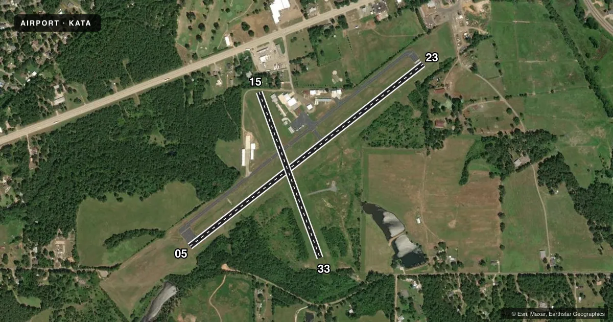
Airport sketch
Runways drawn to scale from FAA survey coordinates, rendered over satellite imagery. Not for navigation.
Approaches & charts
Services on the field
Fuel grades, oxygen, maintenance, ramp storage and lighting — as declared to the FAA by the airport operator.
Fuel & services
- Fuel
- 100LL
- Oxygen (bottled)
- Not available
- Oxygen (bulk)
- Not available
Ramp & ground
- Transient storage
- Tie-down
- Landing fee
- No fee published
- Customs
- Not available
- Lighting schedule
- SEE RMK
- Beacon schedule
- SS-SR
- Beacon
- White / Green (civil land)(WG)
- Wind indicator
- Lighted
- Segmented circle
- Yes
Fuel & FBOs
Cheapest 100LL and Jet A on the field and nearby. Always confirm with the FBO before taxi.
Airport notes
Surface conditions, obstructions, local procedures, lighting outages and other notes published with each FAA cycle.
General notes
- FERAL HOGS & DEER ON ARPT.
- RWY 23, 24 FT MKD POWERLINE 500 FT DSTC.
- RWY 05 TRRN SLOPES +20 FT 670 FT FM THR.
- RWY 33, 42 FT MKD POWERLINE, 285 FT DSTC.
- FOR CD CTC FORT WORTH ARTCC AT 817-858-7584.
Lighting notes
- ACTVT REIL RWY 05 & 23; MIRL RWY 05/23 - CTAF.
Fuel notes
- 100LLFUEL AVBL 24 HRS SELF-SERVE.
Approach & departure obstructions
- 0525 FT TREES, 0 FT DSTC, 165 FT R.
- 2340 FT TREES 0-199 FT FM THR 135 L.
- 15RWY MKD WITH 1 FT YELLOW PLASTIC PIPES.
- 05APCH SLOPE 3:1 TO RWY END BASED ON STRAIGHT OUT.
- 1550 FT UNMKD PWR LINES 560 DSTC ACRS APCH. MKD PWR LINES LWR THAN TREES.
Other notes
- MANAGERCITY/ARPT MGR.
- MANAGEREXT 120.
VFR map & nearby airports
VFR sectional. Tap any ICAO chip to open that airport.
Key facts · KATA
Answer card- ICAO
- KATA
- Name
- HALL-MILLER MUNI
- Location
- ATLANTA, TEXAS
- Elevation
- 280.3 ft MSL
- Traffic pattern altitude
- 1,280.3 ft MSL (1,000 AGL)
- Control tower
- Non-towered (use CTAF)
- Total runways
- 2
- Longest runway
- 05/23 · 3,800 ft
- Published ILS approaches
- 0
- Published frequencies
- 1
- Magnetic variation
- 4°
- Current flight rules
- VFR
- Current wind
- Calm / unavailable
- Favored runway now
- –
Hall-Miller Muni is in Atlanta, Texas. Field elevation is 280.3 ft MSL. The airport has two runways. The longest is runway 05/23 at 3,800 ft. There is no control tower. CTAF is 122.9.
No ILS approaches are published here. Pattern altitude is not published in the facts, so use the standard 1,000 ft AGL for light piston traffic unless the current Chart Supplement says otherwise. The on-field FBO is Hall-Miller Municipal Airport. It carries AVGAS 100LL. Fuel is available 24 hours self-serve.
This is a field where obstacle awareness matters. Published remarks call out power lines near the approaches, trees near runway 05 and a powerline near runway 33. Runway 05 also has terrain that rises about 20 ft farther out. Runway 15 is marked with yellow plastic pipes. Deer and feral hogs are reported on the airport, so plan for wildlife on taxi and landing roll. REIL on runways 05 and 23. MIRL on 05/23 are activated via CTAF. For clearance delivery, contact Fort Worth ARTCC. If you need anything beyond these published notes, check the current Chart Supplement or call the airport operator before departure.