METAR & TAF KEOS
KEOS does not publish a METAR.
Showing the nearest reporting station: KHFJ (MONETT RGNL) · 19.0 NM away. Conditions at KEOS may differ.
METAR · KHFJ
Observed 18:35Z
KHFJ 271835Z AUTO 18012KT 10SM CLR 35/19 A2993 RMK AO2
- Wind
- 180° @ 12 kt
- Visibility
- 10 SM
- Temp / Dew
- 35°C / 19°C
- Altimeter
- 29.93 inHg
- Clouds
- CLR
- Density alt
- 3,943 ft
- Ceiling
- Unlimited
- Rules
- VFR
Airport info & contacts
Manager on record, flight service, ARTCC, attendance schedule and pattern altitude — published by the FAA and refreshed every 28 days.
Location
- From city
- 3 NM S
- VFR sectional
- KANSAS CITY
- ARTCC
- ZKC · KANSAS CITY
- NOTAM facility
- COU (NOTAM-D)
Airport manager
- Name
- CHUCK GRAVES
- Phone
- 417-451-8098
- Address
- 1400 TERRY JOHNSON DR., NEOSHO MO 64850
Flight service · Hours
- FSS COU
- COLUMBIA1-800-WX-BRIEF
- Attendance
- MON-FRI · 0700-1530
- SAT · 0700-1530
- SUN · CLOSED
Frequencies
Tap any row to copy the frequency to your clipboard.
Runways & pattern
Full pagePattern entry · RWY 19
LEFT TRAFFICRunway end performance
| End | TORA | TODA | ASDA | LDA | VGSI | Approach lights | Obstruction |
|---|---|---|---|---|---|---|---|
| 01 | — | — | — | — | PAPI 4-box left(3°) | — | — |
| 19 | — | — | — | — | PAPI 4-box left(3°) | — | 26', trees, 1005' from thr, 370' R of cntrln, slope 30 |
Declared distances in feet. TORA = takeoff run available, TODA = takeoff distance, ASDA = accelerate-stop, LDA = landing distance.
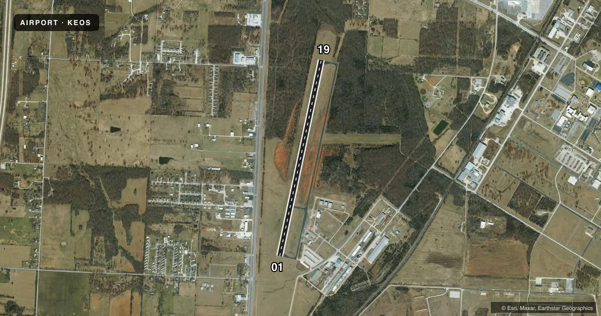
Airport sketch
Runways drawn to scale from FAA survey coordinates, rendered over satellite imagery. Not for navigation.
Approaches & charts
Services on the field
Fuel grades, oxygen, maintenance, ramp storage and lighting — as declared to the FAA by the airport operator.
Fuel & services
- Fuel
- 100LLA1+
- Oxygen (bulk)
- Not available
- Airframe repair
- Not available
- Power plant repair
- Not available
- Other services
- AGRI,INSTR,SURV
Ramp & ground
- Transient storage
- Tie-down
- Hangar
- Landing fee
- No fee published
- Customs
- Not available
- Lighting schedule
- SEE RMK
- Beacon schedule
- SS-SR
- Beacon
- White / Green (civil land)(WG)
- Wind indicator
- Lighted
- Segmented circle
- Yes
Fuel & FBOs
Cheapest 100LL and Jet A on the field and nearby. Always confirm with the FBO before taxi.
Airport notes
Surface conditions, obstructions, local procedures, lighting outages and other notes published with each FAA cycle.
General notes
- WILDLIFE ON & INVOF ARPT.
- GND HAZ CAMP CROWDER FIRING RANGE ACTV - STAY ABV PAT ALT TIL BASE LEG WKDAYS & WKENDS INDEFLY.
- RY 01/19 LINE OF SIGHT OBSTRUCTED BY GRADE CHANGE ON NORTH END.
Lighting notes
- ACTVT REIL RWYS 01 & 19; PAPI RWYS 01 & 19; MIRL RWYS 01/19 - CTAF
Fuel notes
- 100LL24 HR SELF SERVICE 100LL FUEL PUMP.
Other notes
- AUTOMATED UNICOM; 3 CLICKS WX, 4 CLICKS RADIO CHECK.
- 1FOR SVC AFT HRS CALL (417) 439-7887.
VFR map & nearby airports
VFR sectional. Tap any ICAO chip to open that airport.
Key facts · KEOS
Answer card- ICAO
- KEOS
- Name
- NEOSHO HUGH ROBINSON
- Location
- NEOSHO, MISSOURI
- Elevation
- 1,254.6 ft MSL
- Traffic pattern altitude
- 2,254.6 ft MSL (1,000 AGL)
- Control tower
- Non-towered (use CTAF)
- Total runways
- 1
- Longest runway
- 01/19 · 5,001 ft
- Published ILS approaches
- 0
- Published frequencies
- 2
- Magnetic variation
- 2°
- Current flight rules
- VFR
- Current wind
- 180° at 12 kt
- Favored runway now
- RWY 19
Neosho Hugh Robinson Airport sits in Neosho, Missouri. Field elevation is 1,254.6 ft MSL. The airport has one runway, 01/19, which is 5,001 ft long and asphalt. There is no control tower. CTAF and UNICOM are both 122.8. No ILS approaches are published here.
The pattern altitude is not published, so use the standard 1,000 ft AGL for light piston operations unless the current Chart Supplement says otherwise. The on-field FBO is Neosho Hugh Robinson Airport. It carries AVGAS 100LL and Jet A Prist. A 24-hour self-service 100LL pump is available. For after-hours service, the published number is (417) 439-7887.
A few local items matter here. Wildlife is present on and near the airport. Runway 01/19 has a line-of-sight obstruction from a grade change on the north end. Camp Crowder firing range is active, so stay above traffic pattern altitude until the base leg on weekdays and weekends. The runway has medium intensity lighting, runway end identifier lights and PAPI on both ends. Use CTAF for communication. If you are arriving for the first time, brief the terrain and the runway end conditions before you descend.