METAR & TAF KHFJ
Current METAR
Observed 22:15Z
KHFJ 272215Z AUTO 22011G15KT 10SM CLR 36/19 A2987 RMK AO2
- Wind
- 220° @ 11G15 kt
- Visibility
- 10 SM
- Temp / Dew
- 36°C / 19°C
- Altimeter
- 29.87 inHg
- Clouds
- CLR
- Density alt
- 4,214 ft
- Ceiling
- Unlimited
- Rules
- VFR
Airport info & contacts
Manager on record, flight service, ARTCC, attendance schedule and pattern altitude — published by the FAA and refreshed every 28 days.
Location
- From city
- 5 NM W
- VFR sectional
- KANSAS CITY
- ARTCC
- ZKC · KANSAS CITY
- NOTAM facility
- COU (NOTAM-D)
Airport manager
- Name
- STEVE BURNETT
- Phone
- 417-850-1451
- Address
- 1215 STATE HWY 97, PIERCE CITY MO 65723
Flight service · Hours
- FSS COU
- COLUMBIA1-800-WX-BRIEF
- Attendance
- ALL
Frequencies
Tap any row to copy the frequency to your clipboard.
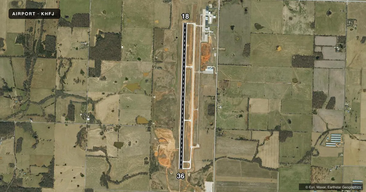
Runways & pattern
Full pagePattern entry · RWY 18
LEFT TRAFFICRunway end performance
| End | TORA | TODA | ASDA | LDA | VGSI | Approach lights | Obstruction |
|---|---|---|---|---|---|---|---|
| 18 | — | — | — | — | PAPI 4-box left(3°) | — | — |
| 36 | — | — | — | — | PAPI 4-box left(3°) | MALSR | — |
Declared distances in feet. TORA = takeoff run available, TODA = takeoff distance, ASDA = accelerate-stop, LDA = landing distance.
Airport sketch
Runways drawn to scale from FAA survey coordinates, rendered over satellite imagery. Not for navigation.
Approaches & charts
Services on the field
Fuel grades, oxygen, maintenance, ramp storage and lighting — as declared to the FAA by the airport operator.
Fuel & services
- Fuel
- 100LLA
- Airframe repair
- Minor
- Power plant repair
- Major
- Other services
- INSTR
Ramp & ground
- Transient storage
- Tie-down
- Hangar
- Landing fee
- No fee published
- Lighting schedule
- SEE RMK
- Beacon schedule
- SS-SR
- Beacon
- White / Green (civil land)(WG)
- Wind indicator
- Yes
- Segmented circle
- No
Fuel & FBOs
Cheapest 100LL and Jet A on the field and nearby. Always confirm with the FBO before taxi.
Airport notes
Surface conditions, obstructions, local procedures, lighting outages and other notes published with each FAA cycle.
General notes
- WILDLIFE & ULTRALIGHTS ON & INVOF ARPT.
- 450 FT OF NORTH END OF ASPHALT TWY MARKED CLSD WITH LARGE YELLOW X'S.
- FOR CD CTC SPRINGFIELD APCH AT 417-868-5620/5619.
Lighting notes
- ACTVT MALSR RWY 36; REIL RWY 18; HIRL RWY 18/36 - CTAF. PAPI RWY 18 & 36 ON CONSLY.
Fuel notes
- 100LLSELF-SERVE FUEL AVBL 24 HRS FOR 100LL ONLY.
Runway surface & condition
- 18/36ASPH TWY SECTIONS NOT FULL STRENGTH.
- 18/36RY 18/36 - 60 FT X 475 FT ASPH SAFETY AREA NORTH OF RY 18 THLD.
Other notes
- 597
- ACFT MAINT ON FLD.
- PRVDD APCHS ARE MAINT FOR A 20:1 GLIDE SLOPE AND TRSNL SFCS FOR A 7:1 SLOPE.
- UNICOM IREG MNTD DURG DALGT HRS.
- MANAGERARPT SUPERINTENDENT.
VFR map & nearby airports
VFR sectional. Tap any ICAO chip to open that airport.
Key facts · KHFJ
Answer card- ICAO
- KHFJ
- Name
- MONETT RGNL
- Location
- MONETT, MISSOURI
- Elevation
- 1,316.1 ft MSL
- Traffic pattern altitude
- 2,316.1 ft MSL (1,000 AGL)
- Control tower
- Non-towered (use CTAF)
- Total runways
- 1
- Longest runway
- 18/36 · 6,001 ft
- Published ILS approaches
- 0
- Published frequencies
- 5
- Magnetic variation
- 2°
- Current flight rules
- VFR
- Current wind
- 220° at 11 kt
- Favored runway now
- RWY 18
Monett Regional Airport sits in Monett, Missouri. The field elevation is 1,316.1 ft MSL. It has one runway, 18/36, which is 6,001 ft long and paved with concrete. There is no control tower. CTAF and UNICOM are both 123.075. Clearance delivery is handled through Springfield Approach when needed.
No ILS approaches are published here. The published pattern altitude is not listed in the facts, so use the current Chart Supplement before you go. The airport uses runway lighting on both ends. Runway 36 has MALSR lighting. Runway 18 has REIL. High intensity runway lights are on 18 and 36 and are controlled by CTAF. PAPI is published on both ends on a consolidated basis.
Monett Regional Airport is on-field with its own FBO, Monett Regional Airport. It carries 100LL and Jet A with Prist. Self-serve 100LL is available 24 hours. UNICOM is irregularly monitored during daylight hours, so do not count on it for real-time coordination. The airport also has aircraft maintenance on the field. Wildlife and ultralights are reported on and near the airport, so keep your scan active in the pattern and on taxi. The asphalt taxiway sections are not full strength for gross weight, so review pavement limits before arrival.