METAR & TAF 17Q
17Q does not publish a METAR.
Showing the nearest reporting station: KEWK (NEWTON-CITY-COUNTY) · 10.2 NM away. Conditions at 17Q may differ.
METAR · KEWK
Observed 18:56Z
KEWK 271856Z AUTO 19017KT 10SM CLR 38/19 A2984 RMK AO2 SLP082 T03830194 $
- Wind
- 190° @ 17 kt
- Visibility
- 10 SM
- Temp / Dew
- 38°C / 19°C
- Altimeter
- 29.84 inHg
- Clouds
- CLR
- Density alt
- 4,744 ft
- Ceiling
- Unlimited
- Rules
- VFR
Airport info & contacts
Manager on record, flight service, ARTCC, attendance schedule and pattern altitude — published by the FAA and refreshed every 28 days.
Location
- From city
- 2 NM S
- VFR sectional
- KANSAS CITY
- ARTCC
- ZKC · KANSAS CITY
- NOTAM facility
- ICT
Airport manager
- Name
- NATHAN HIEBERT
- Phone
- 620-454-9972
- Address
- 974 ALAMO, NEWTON KS 67114
Flight service · Hours
- FSS ICT
- WICHITA1-800-WX-BRIEF
Frequencies
Tap any row to copy the frequency to your clipboard.
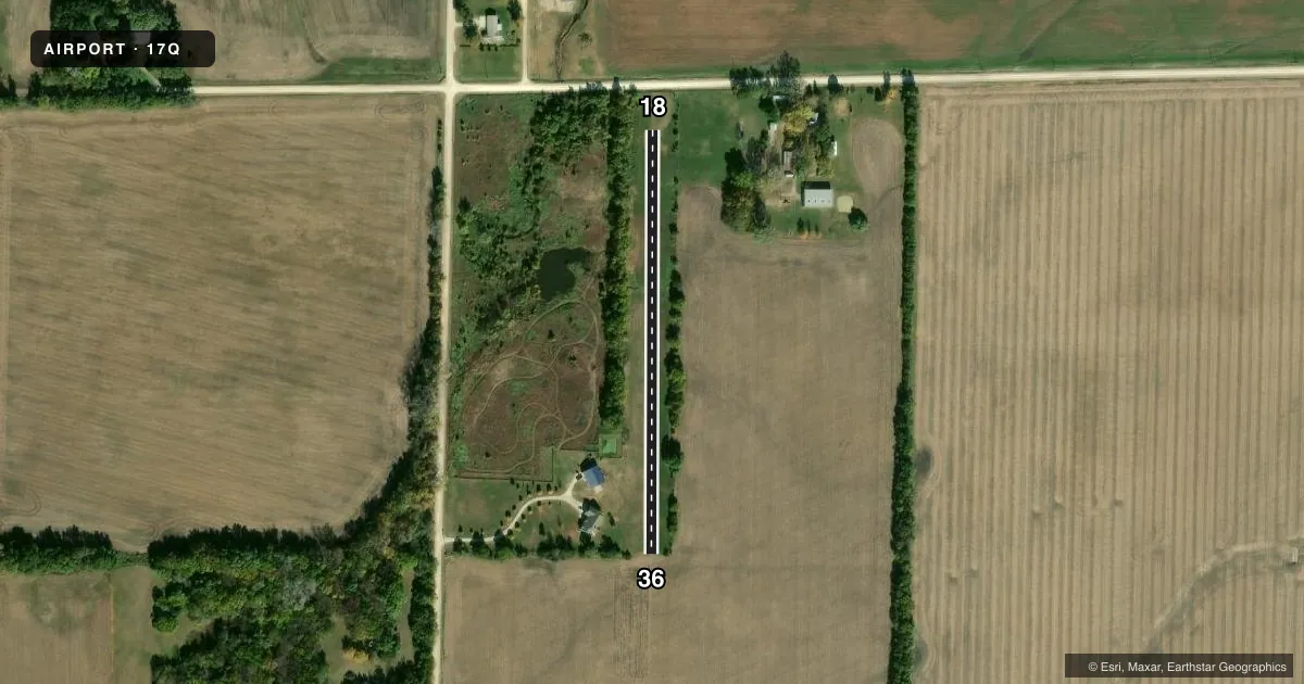
Runways & pattern
Full pagePattern entry · RWY 18
LEFT TRAFFICAirport sketch
Runways drawn to scale from FAA survey coordinates, rendered over satellite imagery. Not for navigation.
Approaches & charts
Services on the field
Fuel grades, oxygen, maintenance, ramp storage and lighting — as declared to the FAA by the airport operator.
Fuel & services
- Fuel
- Not available
Ramp & ground
- Transient storage
- Not published
Fuel & FBOs
Cheapest 100LL and Jet A on the field and nearby. Always confirm with the FBO before taxi.
Airport notes
Surface conditions, obstructions, local procedures, lighting outages and other notes published with each FAA cycle.
Other notes
- MANAGERHIEBERTAVIATION@GMAIL.COM
VFR map & nearby airports
VFR sectional. Tap any ICAO chip to open that airport.
Key facts · 17Q
Answer card- ICAO
- 17Q
- Name
- HIEBERT AIRFIELD
- Location
- GOESSEL, KANSAS
- Elevation
- 1,520 ft MSL
- Traffic pattern altitude
- 2,520 ft MSL (1,000 AGL)
- Control tower
- Non-towered (use CTAF)
- Total runways
- 1
- Longest runway
- 18/36 · 1,200 ft
- Published ILS approaches
- 0
- Published frequencies
- 0
- Magnetic variation
- –
- Current flight rules
- VFR
- Current wind
- 190° at 17 kt
- Favored runway now
- RWY 18
Hiebert Airfield sits in Goessel, Kansas. Field elevation is 1,520 ft MSL. It has one runway. The longest runway is 18/36 at 1,200 ft of turf. This is a non-towered field, so plan to self-announce and keep a close scan for local traffic. No ILS approaches are published here.
Pattern altitude is not published. Use the standard 1,000 ft AGL pattern unless the current FAA Chart Supplement or the airport manager gives you different guidance. At this field elevation, that puts the light aircraft pattern around 2,520 ft MSL. No on-field FBOs are listed. Contact the airport manager directly at HIEBERTAVIATION@GMAIL.COM before arrival for current field status and local operating details.
The runway is short and turf. That matters for takeoff and landing performance, especially after rain or when the grass is soft. There are no published frequencies in the facts provided, so verify current CTAF or airport communications before you go. If you need more detail on local procedures, runway condition, or any operating limits, check the current FAA Chart Supplement or contact the airport manager.