METAR & TAF KEWK
Current METAR
Observed 18:56Z
KEWK 271856Z AUTO 19017KT 10SM CLR 38/19 A2984 RMK AO2 SLP082 T03830194 $
- Wind
- 190° @ 17 kt
- Visibility
- 10 SM
- Temp / Dew
- 38°C / 19°C
- Altimeter
- 29.84 inHg
- Clouds
- CLR
- Density alt
- 4,761 ft
- Ceiling
- Unlimited
- Rules
- VFR
Airport info & contacts
Manager on record, flight service, ARTCC, attendance schedule and pattern altitude — published by the FAA and refreshed every 28 days.
Location
- From city
- 3 NM E
- VFR sectional
- WICHITA
- ARTCC
- ZKC · KANSAS CITY
- NOTAM facility
- EWK (NOTAM-D)
Airport manager
- Name
- BRIAN PALMER
- Phone
- 316-284-6084
- Address
- P.O. BOX 426, NEWTON KS 67114
Flight service · Hours
- FSS ICT
- WICHITA1-800-WX-BRIEF
- Attendance
- 0700-2300
Frequencies
Tap any row to copy the frequency to your clipboard.
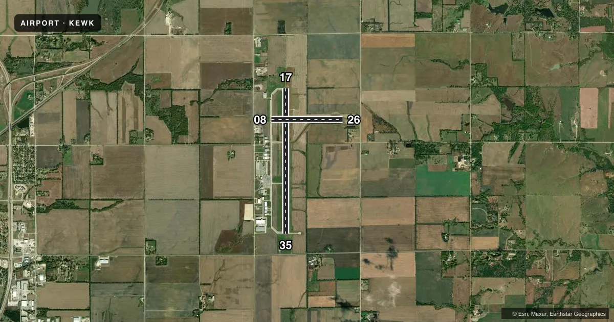
Runways & pattern
Full pagePattern entry · RWY 17
LEFT TRAFFIC| Runway | Heading (°M) | Length | Surface | Traffic |
|---|---|---|---|---|
| 17/35Favored | 174° / 354° | 7,003 ft | CONC | Standard L |
| 08/26 | 84° / 264° | 3,438 ft | ASPH | Standard L |
Runway end performance
| End | TORA | TODA | ASDA | LDA | VGSI | Approach lights | Obstruction |
|---|---|---|---|---|---|---|---|
| 17 | 7,003' | 7,003' | 6,705' | 6,705' | PAPI 2-box left(3°) | MALSR | — |
| 35 | 7,003' | 7,003' | 7,003' | 7,003' | VASI 4-box left(3°) | — | — |
| 08 | 3,438' | 3,438' | 3,438' | 3,438' | PAPI 4-box left(3°) | — | — |
| 26 | 3,438' | 3,438' | 3,438' | 3,438' | PAPI 4-box left(3°) | — | 34', pole, 841' from thr, 272' R of cntrln, slope 18 |
Declared distances in feet. TORA = takeoff run available, TODA = takeoff distance, ASDA = accelerate-stop, LDA = landing distance.
Airport sketch
Runways drawn to scale from FAA survey coordinates, rendered over satellite imagery. Not for navigation.
Approaches & charts
ILS · 1
Services on the field
Fuel grades, oxygen, maintenance, ramp storage and lighting — as declared to the FAA by the airport operator.
Fuel & services
- Fuel
- 100LLA
- Oxygen (bottled)
- Not available
- Oxygen (bulk)
- Low pressure
- Airframe repair
- Major
- Power plant repair
- Major
- Other services
- CHTR,INSTR,SALES
Ramp & ground
- Transient storage
- Tie-down
- Hangar
- Landing fee
- No fee published
- Customs
- Not available
- Lighting schedule
- SEE RMK
- Beacon schedule
- SS-SR
- Beacon
- White / Green (civil land)(WG)
- Wind indicator
- Lighted
- Segmented circle
- No
Fuel & FBOs
Cheapest 100LL and Jet A on the field and nearby. Always confirm with the FBO before taxi.
Airport notes
Surface conditions, obstructions, local procedures, lighting outages and other notes published with each FAA cycle.
General notes
- NO LINE OF SIGHT BETWEEN RWY ENDS.
- SELF-SERVE AIRCRAFT WASH BAY.
- COMPASS ROSE RIGHT OF APCH END RY 35
- FOR CD CTC WICHITA APCH AT 316-350-1520.
Lighting notes
- ACTVT MALSR RWY 17; REIL RWYS 08 & 26 &35; VASI RWY 35; PAPI RWYS 08 & 26 & 17; HIRL RWY 17/35 - CTAF.
Other notes
- PROVIDED A CLEAR APPROACH TO EACH RWY IS MAINTAINED FOR A MINIMUM 20:1 GLIDE SLOPE AND THE TRANSITIONAL SURFACE IS MAINTAINED FOR A 7:1 SLOPE.
- 1AFT HRS 316-284-6084.
VFR map & nearby airports
VFR sectional. Tap any ICAO chip to open that airport.
Key facts · KEWK
Answer card- ICAO
- KEWK
- Name
- NEWTON-CITY-COUNTY
- Location
- NEWTON, KANSAS
- Elevation
- 1,533.5 ft MSL
- Traffic pattern altitude
- 2,533.5 ft MSL (1,000 AGL)
- Control tower
- Non-towered (use CTAF)
- Total runways
- 2
- Longest runway
- 17/35 · 7,003 ft
- Published ILS approaches
- 1
- Published frequencies
- 5
- Magnetic variation
- 6°
- Current flight rules
- VFR
- Current wind
- 190° at 17 kt
- Favored runway now
- RWY 17
Newton-City-County Airport (KEWK) sits in Newton, Kansas. The field elevation is 1,533.5 ft MSL. It has two runways. The longest is runway 17/35 at 7,003 ft. Runway 08/26 is 3,438 ft. There is no control tower. CTAF and UNICOM are both 123.0. Wichita Approach handles approach and departure work on 125.5 and 306.2. Clearance delivery is on 126.55.
KEWK has one ILS approach. It is for runway 17. The published pattern altitude is not listed. Use the standard 1,000 ft AGL pattern unless the current Chart Supplement says otherwise. That puts the light-piston pattern near 2,533.5 ft MSL. Runway 17 also has MALSR lighting. REIL is installed on runways 08, 26 and 35. PAPI is installed on runways 08, 26 and 17. Runway 35 has VASI. HIRL is on runway 17/35 and is controlled by CTAF.
Metro North Flight Support is on the field. It carries 100LL and Jet A. The airport remarks also note a self-serve aircraft wash bay. There is no line of sight between runway ends. The published remarks say the airport keeps clear approaches to each runway. For a first visit, brief the lighting setup and the non-towered flow before you go. If you need current noise, curfew, or operational restrictions, check the current FAA Chart Supplement or call the airport operator directly.