METAR & TAF K22
K22 does not publish a METAR.
Showing the nearest reporting station: KHUT (HUTCHINSON RGNL) · 5.4 NM away. Conditions at K22 may differ.
METAR · KHUT
Observed 15:52Z
KHUT 271552Z 19013G21KT 10SM CLR 34/18 A2985 RMK AO2 SLP078 T03440183
- Wind
- 190° @ 13G21 kt
- Visibility
- 10 SM
- Temp / Dew
- 34°C / 18°C
- Altimeter
- 29.85 inHg
- Clouds
- CLR
- Density alt
- 4,271 ft
- Ceiling
- Unlimited
- Rules
- VFR
Airport info & contacts
Manager on record, flight service, ARTCC, attendance schedule and pattern altitude — published by the FAA and refreshed every 28 days.
Location
- From city
- 2 NM S
- VFR sectional
- WICHITA
- ARTCC
- ZKC · KANSAS CITY
- NOTAM facility
- ICT (NOTAM-D)
Airport manager
- Name
- JARED OATNEY
- Phone
- 620-921-1207
- Address
- 520 S MAIN ST, HUTCHINSON KS 67505
Flight service · Hours
- FSS ICT
- WICHITA1-800-WX-BRIEF
- Attendance
- Unattended
Frequencies
Tap any row to copy the frequency to your clipboard.
Runways & pattern
Full pagePattern entry · RWY 18
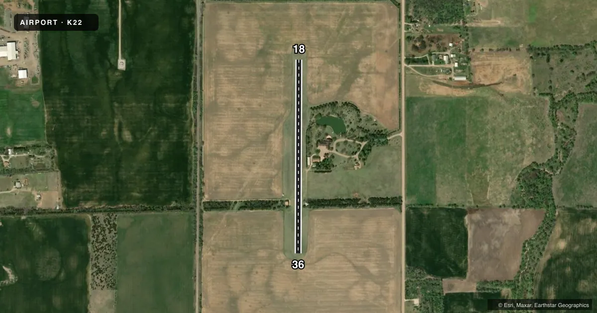
LEFT TRAFFICAirport sketch
Runways drawn to scale from FAA survey coordinates, rendered over satellite imagery. Not for navigation.
Approaches & charts
Services on the field
Fuel grades, oxygen, maintenance, ramp storage and lighting — as declared to the FAA by the airport operator.
Fuel & services
- Fuel
- Not available
Ramp & ground
- Transient storage
- Not published
- Landing fee
- No fee published
- Wind indicator
- Yes
- Segmented circle
- No
Fuel & FBOs
Cheapest 100LL and Jet A on the field and nearby. Always confirm with the FBO before taxi.
Airport notes
Surface conditions, obstructions, local procedures, lighting outages and other notes published with each FAA cycle.
General notes
- FOR CD CTC WICHITA APCH AT 316-350-1520.
- TREES 75 FT FM RWY CNTRLN 700 FT FM S END OF RWY 18/36.
Runway surface & condition
- 18/36TREES EAST & WEST SIDE OF RWY.
Other notes
- PROVIDED A 20:1 GLIDE SLOPE AND A 7:1 TRANSITIONAL SLOPE ARE MAINTAINED.
- MANAGER620-921-1207 JARED@OATNEY.COM
VFR map & nearby airports
VFR sectional. Tap any ICAO chip to open that airport.
Key facts · K22
Answer card- ICAO
- K22
- Name
- MILLS FLD
- Location
- SOUTH HUTCHINSON, KANSAS
- Elevation
- 1,536 ft MSL
- Traffic pattern altitude
- 2,536 ft MSL (1,000 AGL)
- Control tower
- Non-towered (use CTAF)
- Total runways
- 1
- Longest runway
- 18/36 · 2,400 ft
- Published ILS approaches
- 0
- Published frequencies
- 0
- Magnetic variation
- 7°
- Current flight rules
- VFR
- Current wind
- 190° at 13 kt
- Favored runway now
- RWY 18
Mills Fld sits in South Hutchinson, Kansas. Field elevation is 1,536 ft MSL. The airport has one runway. Runway 18/36 is 2,400 ft of turf. No control tower is published for the field. No ILS approaches are published either.
Pattern altitude is not published. Use the current Chart Supplement for the published pattern guidance before you fly in. Trees are a real factor here. Published remarks say trees sit 75 ft from the runway centerline. They are also 700 ft from the south end of runway 18/36. Trees are listed on both the east and west sides of the runway. The published glide slope is 20 to 1. The transitional slope is 7 to 1.
There are no on-field FBOs listed in the facts. FBO options vary. Contact the airport operator directly before arrival, or call the field on CTAF/UNICOM for current FBO availability. For clearance delivery, Wichita Approach is listed in the remarks at 316-350-1520. If you are planning a first visit, review the current Chart Supplement for any updated airport notes before you go. The field is turf, so plan for surface condition checks after rain or during soft-field periods.