METAR & TAF 8KS
8KS does not publish a METAR.
Showing the nearest reporting station: KLYO (LYONS-RICE COUNTY MUNI) · 8.0 NM away. Conditions at 8KS may differ.
METAR · KLYO
Observed 18:55Z
KLYO 271855Z AUTO 18019G22KT 10SM CLR 41/15 A2982 RMK AO2 T04140155
- Wind
- 180° @ 19G22 kt
- Visibility
- 10 SM
- Temp / Dew
- 41°C / 15°C
- Altimeter
- 29.82 inHg
- Clouds
- CLR
- Density alt
- 5,323 ft
- Ceiling
- Unlimited
- Rules
- VFR
Airport info & contacts
Manager on record, flight service, ARTCC, attendance schedule and pattern altitude — published by the FAA and refreshed every 28 days.
Location
- From city
- 7 NM SE
- VFR sectional
- WICHITA
- ARTCC
- ZKC · KANSAS CITY
- NOTAM facility
- ICT
Airport manager
- Name
- SPENCER MAXWELL
- Phone
- 620-680-0217
- Address
- 2271 AVE R., STERLING KS 67579
Flight service · Hours
- FSS ICT
- WICHITA1-800-WX-BRIEF
Frequencies
Tap any row to copy the frequency to your clipboard.
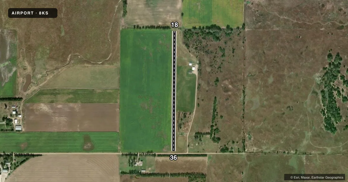
Runways & pattern
Full pagePattern entry · RWY 18
LEFT TRAFFICRunway end performance
| End | TORA | TODA | ASDA | LDA | VGSI | Approach lights | Obstruction |
|---|---|---|---|---|---|---|---|
| 18 | — | — | — | — | — | — | 40', tree, 390' from thr, 90' R of cntrln, slope 9 |
| 36 | — | — | — | — | — | — | 25', trees, 63' from thr, 0' R of cntrln, slope 2 |
Declared distances in feet. TORA = takeoff run available, TODA = takeoff distance, ASDA = accelerate-stop, LDA = landing distance.
Airport sketch
Runways drawn to scale from FAA survey coordinates, rendered over satellite imagery. Not for navigation.
Approaches & charts
Services on the field
Fuel grades, oxygen, maintenance, ramp storage and lighting — as declared to the FAA by the airport operator.
Fuel & services
- Fuel
- Not available
Ramp & ground
- Transient storage
- Not published
Fuel & FBOs
Cheapest 100LL and Jet A on the field and nearby. Always confirm with the FBO before taxi.
Airport notes
Surface conditions, obstructions, local procedures, lighting outages and other notes published with each FAA cycle.
General notes
- WILDLIFE INVOF RWY.
VFR map & nearby airports
VFR sectional. Tap any ICAO chip to open that airport.
Key facts · 8KS
Answer card- ICAO
- 8KS
- Name
- MAXWELL AVIATION
- Location
- LYONS, KANSAS
- Elevation
- 1,677 ft MSL
- Traffic pattern altitude
- 2,677 ft MSL (1,000 AGL)
- Control tower
- Non-towered (use CTAF)
- Total runways
- 1
- Longest runway
- 18/36 · 2,550 ft
- Published ILS approaches
- 0
- Published frequencies
- 1
- Magnetic variation
- –
- Current flight rules
- VFR
- Current wind
- 180° at 19 kt
- Favored runway now
- RWY 18
Maxwell Aviation is in Lyons, Kansas. The field elevation is 1,677 ft MSL. It has one runway. Runway 18/36 is 2,550 ft of turf, which makes runway length and surface condition the main planning items here. There is no control tower. CTAF is 122.9.
No ILS approaches are published. Pattern altitude is not published, so use the standard 1,000 ft AGL pattern unless the current Chart Supplement says otherwise. That puts the pattern at about 2,677 ft MSL based on the listed field elevation. Wildlife is noted in the runway area. Plan your arrival and departure with that in mind, especially on taxi, takeoff and landing roll.
There are no on-field FBOs listed in the facts. Contact the airport operator directly or call the field on CTAF for current services before you go. For a first-time stop, the big things are the turf surface, the single runway layout and the lack of published instrument approach support. Check the current Chart Supplement for any updated remarks before flying in.