METAR & TAF 9KS
9KS does not publish a METAR.
Showing the nearest reporting station: KPTT (PRATT RGNL) · 23.4 NM away. Conditions at 9KS may differ.
METAR · KPTT
Observed 17:15Z
KPTT 271715Z AUTO 20013G18KT 10SM CLR 39/16 A2987 RMK AO2 T03900160
- Wind
- 200° @ 13G18 kt
- Visibility
- 10 SM
- Temp / Dew
- 39°C / 16°C
- Altimeter
- 29.87 inHg
- Clouds
- CLR
- Density alt
- 5,660 ft
- Ceiling
- Unlimited
- Rules
- VFR
Airport info & contacts
Manager on record, flight service, ARTCC, attendance schedule and pattern altitude — published by the FAA and refreshed every 28 days.
Location
- From city
- 3 NM NE
- VFR sectional
- WICHITA
- ARTCC
- ZKC · KANSAS CITY
- NOTAM facility
- ICT (NOTAM-D)
Airport manager
- Name
- MS STACY BARNES
- Phone
- 620-723-2751
- Address
- 300 S. MAIN ST, GREENSBURG KS 67054-1799
Flight service · Hours
- FSS ICT
- WICHITA1-800-WX-BRIEF
Frequencies
Tap any row to copy the frequency to your clipboard.
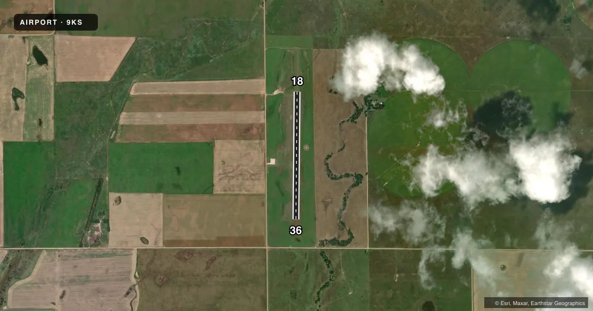
Runways & pattern
Full pagePattern entry · RWY 18
LEFT TRAFFICAirport sketch
Runways drawn to scale from FAA survey coordinates, rendered over satellite imagery. Not for navigation.
Approaches & charts
Services on the field
Fuel grades, oxygen, maintenance, ramp storage and lighting — as declared to the FAA by the airport operator.
Fuel & services
- Fuel
- Not available
- Oxygen (bottled)
- Not available
- Oxygen (bulk)
- Not available
- Airframe repair
- Not available
- Power plant repair
- Not available
Ramp & ground
- Transient storage
- Buoy
- Wind indicator
- Yes
- Segmented circle
- Yes
Fuel & FBOs
Cheapest 100LL and Jet A on the field and nearby. Always confirm with the FBO before taxi.
Airport notes
Surface conditions, obstructions, local procedures, lighting outages and other notes published with each FAA cycle.
General notes
- TWYS AND PRKG MKD WITH 2 INCH BLUE AND WHITE PVC PIPE.
- FOR ASSISTANCE AT ARPT CALL 620-723-2691.
- TIEDOWNS & PKG MIDFIELD.
Approach & departure obstructions
- 18RWY MKD WITH 3-FT DIA YELLOW CONES. 10 FT X 60 FT THLD MARKING.
- 36RWY MKD WITH 3-FT DIA YELLOW CONES. 10 FT X 60 FT THLD MARKING.
Other notes
- FOUR FOR SNGL ENG ACFT, TWO FOR TWIN ENG ACFT.
- MANAGERCITY ADMINISTRATOR/AMGR.
VFR map & nearby airports
VFR sectional. Tap any ICAO chip to open that airport.
Key facts · 9KS
Answer card- ICAO
- 9KS
- Name
- GREENSBURG MUNI
- Location
- GREENSBURG, KANSAS
- Elevation
- 2,192 ft MSL
- Traffic pattern altitude
- 3,192 ft MSL (1,000 AGL)
- Control tower
- Non-towered (use CTAF)
- Total runways
- 1
- Longest runway
- 18/36 · 3,200 ft
- Published ILS approaches
- 0
- Published frequencies
- 1
- Magnetic variation
- –
- Current flight rules
- VFR
- Current wind
- 200° at 13 kt
- Favored runway now
- RWY 18
Greensburg Muni sits in Greensburg, Kansas. The field elevation is 2,192 ft MSL. It has one runway. Runway 18/36 is 3,200 ft of turf, so plan for grass-field performance and surface condition checks before you go. This is an uncontrolled airport with no control tower. CTAF is 122.9.
No ILS approaches are published here. The pattern altitude is not published, so use the standard 1,000 ft AGL unless the current Chart Supplement says otherwise. That puts the pattern at 3,192 ft MSL based on the field elevation. Runway 18 and Runway 36 are both marked with yellow cones and a threshold marking. Taxiways and parking are marked with blue and white PVC pipe.
There are no on-field FBOs listed. Tie-downs and parking are midfield. The published remarks say there are four tie-downs for single-engine aircraft. There are two for twin-engine aircraft. If you need airport assistance, call the airport at 620-723-2691. The city administrator is the airport manager. For a first visit, the main things to plan around are the turf surface, the lack of tower service and the need to verify current field conditions before arrival.