METAR & TAF 3K8
3K8 does not publish a METAR.
Showing the nearest reporting station: KPTT (PRATT RGNL) · 40.1 NM away. Conditions at 3K8 may differ.
METAR · KPTT
Observed 17:15Z
KPTT 271715Z AUTO 20013G18KT 10SM CLR 39/16 A2987 RMK AO2 T03900160
- Wind
- 200° @ 13G18 kt
- Visibility
- 10 SM
- Temp / Dew
- 39°C / 16°C
- Altimeter
- 29.87 inHg
- Clouds
- CLR
- Density alt
- 5,529 ft
- Ceiling
- Unlimited
- Rules
- VFR
Airport info & contacts
Manager on record, flight service, ARTCC, attendance schedule and pattern altitude — published by the FAA and refreshed every 28 days.
Location
- From city
- 3 NM S
- VFR sectional
- WICHITA
- ARTCC
- ZKC · KANSAS CITY
- NOTAM facility
- ICT (NOTAM-D)
Airport manager
- Name
- RODNEY VANCE
- Phone
- 620-582-2933
- Address
- 401 S. PHILADELPHIA AVE., PO BOX 685, COLDWATER KS 67029
Flight service · Hours
- FSS ICT
- WICHITA1-800-WX-BRIEF
- Attendance
- Unattended
Frequencies
Tap any row to copy the frequency to your clipboard.
Runways & pattern
Full pagePattern entry · RWY 17
LEFT TRAFFICRunway end performance
| End | TORA | TODA | ASDA | LDA | VGSI | Approach lights | Obstruction |
|---|---|---|---|---|---|---|---|
| 17 | — | — | — | — | PAPI 2-box left(3°) | — | — |
| 35 | — | — | — | — | PAPI 2-box left(3°) | — | — |
Declared distances in feet. TORA = takeoff run available, TODA = takeoff distance, ASDA = accelerate-stop, LDA = landing distance.
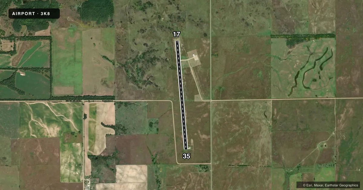
Airport sketch
Runways drawn to scale from FAA survey coordinates, rendered over satellite imagery. Not for navigation.
Approaches & charts
Services on the field
Fuel grades, oxygen, maintenance, ramp storage and lighting — as declared to the FAA by the airport operator.
Fuel & services
- Fuel
- 100LL
Ramp & ground
- Transient storage
- Tie-down
- Landing fee
- No fee published
- Lighting schedule
- SEE RMK
- Beacon schedule
- SS-SR
- Beacon
- White / Green (civil land)(WG)
- Wind indicator
- Lighted
- Segmented circle
- No
Fuel & FBOs
Cheapest 100LL and Jet A on the field and nearby. Always confirm with the FBO before taxi.
Airport notes
Surface conditions, obstructions, local procedures, lighting outages and other notes published with each FAA cycle.
General notes
- FOR CD CTC KANSAS CITY ARTCC AT 913-254-8508.
- FOR FUEL CALL COUNTY OFC 620-582-2933 OR AFTER 1630 CALL SHERIFF 620-582-2511.
Lighting notes
- ACTIVATE REIL RY 17/35; PAPI RY 17/35; MIRL RY 17/35 - CTAF.
Approach & departure obstructions
- 174 FT BERM, 0-199 FT DSTC, 100 L.
Other notes
- PROVIDED APPROACH TO EACH RWY IS MAINTAINED FOR A MIN 20:1 GLIDE SLOPE & THE TRANSITIONAL SFC BE MAINTAINED FOR A 7:1 SLOPE.
- MANAGERFOR FUEL & AFTR ADNDT-PH NUMBERS LISTED IN PILOT LOUNGE.
VFR map & nearby airports
VFR sectional. Tap any ICAO chip to open that airport.
Key facts · 3K8
Answer card- ICAO
- 3K8
- Name
- COMANCHE COUNTY
- Location
- COLDWATER, KANSAS
- Elevation
- 2,086.1 ft MSL
- Traffic pattern altitude
- 3,086.1 ft MSL (1,000 AGL)
- Control tower
- Non-towered (use CTAF)
- Total runways
- 1
- Longest runway
- 17/35 · 4,500 ft
- Published ILS approaches
- 0
- Published frequencies
- 1
- Magnetic variation
- 5°
- Current flight rules
- VFR
- Current wind
- 200° at 13 kt
- Favored runway now
- RWY 17
Comanche County Airport sits in Coldwater, Kansas. The field elevation is 2,086.1 ft MSL. It has one runway. Runway 17/35 is 4,500 ft of concrete, so plan for a modest runway length at a higher-elevation field. There is no control tower. CTAF is 122.9.
No ILS approaches are published here. The pattern altitude is not published, so use the standard 1,000 ft AGL for light piston traffic unless the current Chart Supplement says otherwise. The airport uses runway end identifier lights, PAPI and medium intensity runway lights on 17/35. Those lights are activated via CTAF. There is also a 4-foot berm near the departure end of runway 17, offset to the left side. That is worth keeping in mind on the takeoff roll and initial climb.
Comanche County Airport has one on-field FBO listed as Comanche County Airport. It carries 100LL. For fuel and after-hours help, the published remarks point pilots to the County Office or the Sheriff. Phone numbers are also listed in the pilot lounge. If you need clearance delivery, contact Kansas City ARTCC. For a first visit, treat this as a non-towered field with a single runway, higher field elevation and no published ILS.