METAR & TAF KMEJ
KMEJ does not publish a METAR.
Showing the nearest reporting station: KLBL (LIBERAL MID-AMERICA RGNL) · 32.1 NM away. Conditions at KMEJ may differ.
METAR · KLBL
Observed 15:56Z
KLBL 271556Z AUTO 21013KT 10SM CLR 36/17 A2994 RMK AO2 SLP093 T03560167
- Wind
- 210° @ 13 kt
- Visibility
- 10 SM
- Temp / Dew
- 36°C / 17°C
- Altimeter
- 29.94 inHg
- Clouds
- CLR
- Density alt
- 5,629 ft
- Ceiling
- Unlimited
- Rules
- VFR
Airport info & contacts
Manager on record, flight service, ARTCC, attendance schedule and pattern altitude — published by the FAA and refreshed every 28 days.
Location
- From city
- 1 NM W
- VFR sectional
- WICHITA
- ARTCC
- ZKC · KANSAS CITY
- NOTAM facility
- ICT (NOTAM-D)
Airport manager
- Name
- DEAN CORDES
- Phone
- 620-873-2091
- Address
- 132 SOUTH FOWLER, PO BOX 338, MEADE KS 67864
Flight service · Hours
- FSS ICT
- WICHITA1-800-WX-BRIEF
- Attendance
- MON-FRI · 0800-1700
Frequencies
Tap any row to copy the frequency to your clipboard.
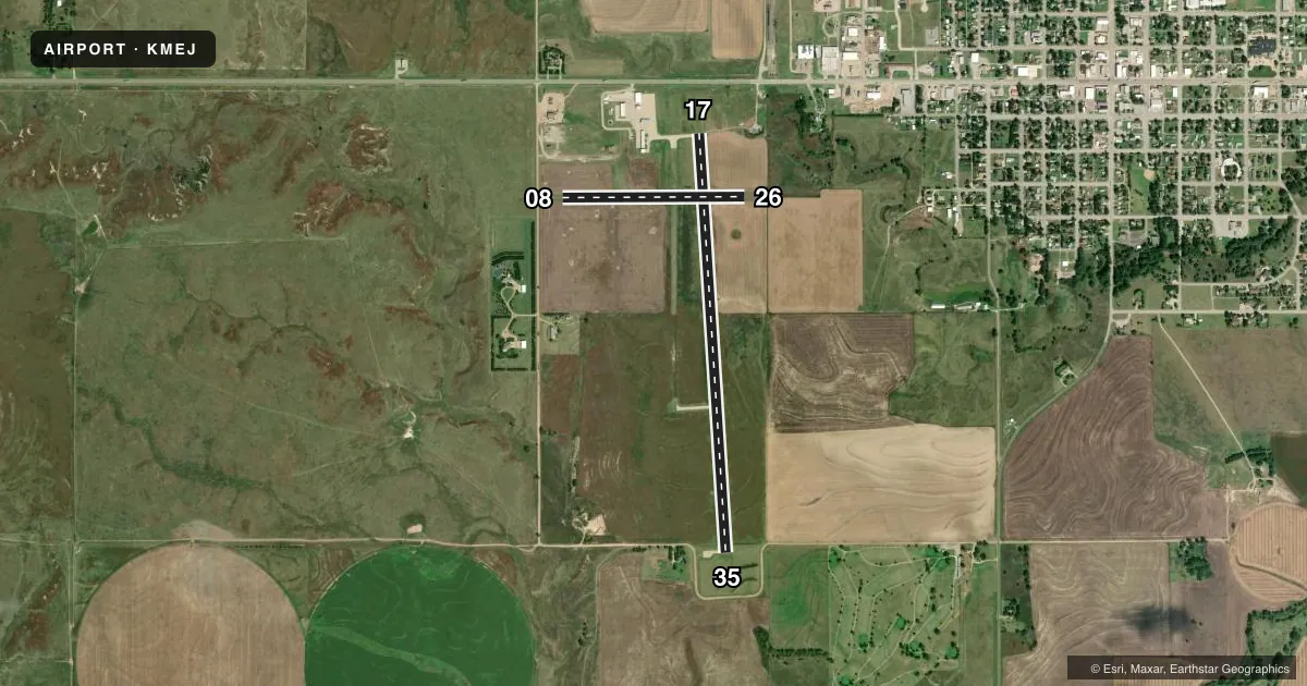
Runways & pattern
Full pagePattern entry · RWY 17
LEFT TRAFFIC| Runway | Heading (°M) | Length | Surface | Traffic |
|---|---|---|---|---|
| 17/35Favored | 168° / 348° | 4,800 ft | CONC | Standard L |
| 08/26 | 82° / 262° | 2,085 ft | TURF | Standard L |
Runway end performance
| End | TORA | TODA | ASDA | LDA | VGSI | Approach lights | Obstruction |
|---|---|---|---|---|---|---|---|
| 17 | — | — | — | — | PAPI 2-box left(3°) | — | 10', road, 575' from thr, 0' R of cntrln, slope 37 |
| 35 | — | — | — | — | PAPI 2-box left(3°) | — | 10', road, 500' from thr, 0' R of cntrln, slope 30 |
| 08 | — | — | — | — | — | — | 17', road, 284' from thr, 0' R of cntrln, slope 16 |
Declared distances in feet. TORA = takeoff run available, TODA = takeoff distance, ASDA = accelerate-stop, LDA = landing distance.
Airport sketch
Runways drawn to scale from FAA survey coordinates, rendered over satellite imagery. Not for navigation.
Approaches & charts
Services on the field
Fuel grades, oxygen, maintenance, ramp storage and lighting — as declared to the FAA by the airport operator.
Fuel & services
- Fuel
- 100LL
- Oxygen (bottled)
- Not available
- Oxygen (bulk)
- Not available
- Airframe repair
- Major
- Power plant repair
- Major
- Other services
- AGRI,INSTR
Ramp & ground
- Transient storage
- Tie-down
- Hangar
- Landing fee
- No fee published
- Lighting schedule
- SEE RMK
- Beacon schedule
- SS-SR
- Beacon
- White / Green (civil land)(WG)
- Wind indicator
- Lighted
- Segmented circle
- Yes
Fuel & FBOs
Cheapest 100LL and Jet A on the field and nearby. Always confirm with the FBO before taxi.
Airport notes
Surface conditions, obstructions, local procedures, lighting outages and other notes published with each FAA cycle.
General notes
- TWY 'B' CLSD PERMLY.
- FOR CD CTC KANSAS CITY ARTCC AT 913-254-8508.
Lighting notes
- ACTVT REIL RWY 17 & 35; PAPI RWY 17 & 35; MIRL RWY 17/35 - CTAF.
Fuel notes
- 100LL24 HR SELF SVC.
Other notes
- PRVDD APCH TO EACH RWY IS MAINTD FOR A MIN 20:1 GLIDE SLOPE AND THE TRSNL SFC BE MAINTD FOR A 7:1 SLOPE.
- OWNERCITY ADMINISTRATOR/AIRPORT MGR.
- MANAGERCRAIG STRATTON, BRINGHAM FLYING SVC-FBO 620-873-5191.
VFR map & nearby airports
VFR sectional. Tap any ICAO chip to open that airport.
Key facts · KMEJ
Answer card- ICAO
- KMEJ
- Name
- MEADE MUNI
- Location
- MEADE, KANSAS
- Elevation
- 2,527 ft MSL
- Traffic pattern altitude
- 3,527 ft MSL (1,000 AGL)
- Control tower
- Non-towered (use CTAF)
- Total runways
- 2
- Longest runway
- 17/35 · 4,800 ft
- Published ILS approaches
- 0
- Published frequencies
- 2
- Magnetic variation
- 8°
- Current flight rules
- VFR
- Current wind
- 210° at 13 kt
- Favored runway now
- RWY 17
Meade Muni sits in Meade, Kansas. The field elevation is 2,527 ft MSL. It has two runways. The longest is 4,800 ft of concrete on 17/35. The other runway is 08/26 at 2,085 ft of turf. There is no control tower. CTAF and UNICOM are both 122.8. No ILS approaches are published here.
Pattern altitude is not published. Use the standard 1,000 ft AGL pattern for light piston traffic unless the current Chart Supplement says otherwise. Runway 17/35 has REIL, PAPI and MIRL lighting. Taxiway B is closed permanently, so plan your ground movement with that in mind. 100LL is available 24 hours self-serve on the field.
Meade sits in southwest Kansas. The elevation is high enough that density altitude can matter on warm days. Expect longer takeoff rolls than you would at a lower field. The published remarks also call for a maintained approach surface to each runway. If you need clearance delivery, contact Kansas City ARTCC at 913-254-8508. On field fuel is listed at Meade Municipal Airport. The published contact is (620) 873-2091. A second airport contact is listed as Craig Stratton with Bringham Flying Service FBO at 620-873-5191.