METAR & TAF K17
K17 does not publish a METAR.
Showing the nearest reporting station: KGCK (GARDEN CITY RGNL) · 23.8 NM away. Conditions at K17 may differ.
METAR · KGCK
Observed 11:54Z
KGCK 271154Z AUTO 16007KT 10SM CLR 23/15 A2988 RMK AO2 SLP072 T02280150 10261 20222 50001
- Wind
- 160° @ 7 kt
- Visibility
- 10 SM
- Temp / Dew
- 23°C / 15°C
- Altimeter
- 29.88 inHg
- Clouds
- CLR
- Density alt
- 4,457 ft
- Ceiling
- Unlimited
- Rules
- VFR
Airport info & contacts
Manager on record, flight service, ARTCC, attendance schedule and pattern altitude — published by the FAA and refreshed every 28 days.
Location
- From city
- 2 NM SW
- VFR sectional
- WICHITA
- ARTCC
- ZKC · KANSAS CITY
- NOTAM facility
- ICT (NOTAM-D)
Airport manager
- Name
- NATHAN MOORE
- Phone
- 620-846-0550
- Address
- 300 W. GERONIMO ST., BOX 378, MONTEZUMA KS 67867
Flight service · Hours
- FSS ICT
- WICHITA1-800-WX-BRIEF
- Attendance
- Unattended
Frequencies
Tap any row to copy the frequency to your clipboard.
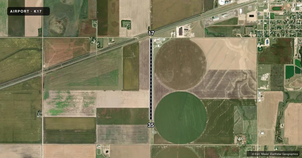
Runways & pattern
Full pagePattern entry · RWY 17
LEFT TRAFFICRunway end performance
| End | TORA | TODA | ASDA | LDA | VGSI | Approach lights | Obstruction |
|---|---|---|---|---|---|---|---|
| 17 | — | — | — | — | — | — | 15', road, 201' from thr, 125' R of cntrln, slope 0 |
| 35 | — | — | — | — | — | — | 15', road, 201' from thr, 125' R of cntrln, slope 0 |
Declared distances in feet. TORA = takeoff run available, TODA = takeoff distance, ASDA = accelerate-stop, LDA = landing distance.
Airport sketch
Runways drawn to scale from FAA survey coordinates, rendered over satellite imagery. Not for navigation.
Approaches & charts
Services on the field
Fuel grades, oxygen, maintenance, ramp storage and lighting — as declared to the FAA by the airport operator.
Fuel & services
- Fuel
- Not available
Ramp & ground
- Transient storage
- Tie-down
- Lighting schedule
- SEE RMK
- Wind indicator
- Yes
- Segmented circle
- No
Fuel & FBOs
Cheapest 100LL and Jet A on the field and nearby. Always confirm with the FBO before taxi.
Airport notes
Surface conditions, obstructions, local procedures, lighting outages and other notes published with each FAA cycle.
General notes
- +6 FT IRRIGATION ENGINE/PUMP LCTD ON RY 17/35 WEST EDGE NEAR WINDSOCK.
- FOR CD CTC KANSAS CITY ARTCC AT 913-254-8508.
Lighting notes
- ACTVT MIRL RY 17/35 - CTAF.
Approach & departure obstructions
- 1715 FT RD PARALLEL TO RWY, WEST SIDE.
Other notes
- PROVIDED MAINTAIN CLEAR 20:1 APCH AND 7:1 TRANSITIONAL SURFACE.
- MANAGEROR 620-846-0506 WARREN WRIGHT, CITY SUPT.
VFR map & nearby airports
VFR sectional. Tap any ICAO chip to open that airport.
Key facts · K17
Answer card- ICAO
- K17
- Name
- MONTEZUMA MUNI
- Location
- MONTEZUMA, KANSAS
- Elevation
- 2,780 ft MSL
- Traffic pattern altitude
- 3,780 ft MSL (1,000 AGL)
- Control tower
- Non-towered (use CTAF)
- Total runways
- 1
- Longest runway
- 17/35 · 4,000 ft
- Published ILS approaches
- 0
- Published frequencies
- 1
- Magnetic variation
- 8°
- Current flight rules
- VFR
- Current wind
- 160° at 7 kt
- Favored runway now
- RWY 17
Montezuma Muni is in Montezuma, Kansas. The field elevation is 2,780 ft MSL. It has one runway, 17/35, which is 4,000 ft of asphalt. There is no control tower. CTAF is 122.9.
No ILS approaches are published here. The pattern altitude is not published in the facts, so plan to verify the current pattern altitude before arrival. The airport sits in southwest Kansas, so density altitude can be a factor in warm weather. That matters with a 4,000 ft runway at this elevation.
Published remarks note medium intensity runway lights on 17/35. They are activated by the CTAF. There is also a 6 ft irrigation engine and pump on the west edge of the runway near the windsock. A 15 ft road runs parallel to runway 17 on the west side. Keep the clear 20 to 1 approach surface and 7 to 1 transitional surface in mind.
No on-field FBOs are listed in the facts. Contact the airport operator directly before arrival. You can also call the field on CTAF for current service status. For clearance delivery, contact Kansas City ARTCC at 913-254-8508. If you are planning a first visit, review the current Chart Supplement before departure so you have the latest notes for lighting, obstacles and any local operating details.