METAR & TAF 3K4
3K4 does not publish a METAR.
Showing the nearest reporting station: KLBL (LIBERAL MID-AMERICA RGNL) · 28.0 NM away. Conditions at 3K4 may differ.
METAR · KLBL
Observed 14:56Z
KLBL 271456Z AUTO 20010KT 10SM CLR 33/17 A2995 RMK AO2 SLP095 T03280167 50004
- Wind
- 200° @ 10 kt
- Visibility
- 10 SM
- Temp / Dew
- 33°C / 17°C
- Altimeter
- 29.95 inHg
- Clouds
- CLR
- Density alt
- 5,479 ft
- Ceiling
- Unlimited
- Rules
- VFR
Airport info & contacts
Manager on record, flight service, ARTCC, attendance schedule and pattern altitude — published by the FAA and refreshed every 28 days.
Location
- From city
- 8 NM WNW
- VFR sectional
- WICHITA
- ARTCC
- ZKC · KANSAS CITY
- NOTAM facility
- ICT
Airport manager
- Name
- HAYDEN BORTH
- Phone
- 620-629-7983
- Address
- 10209 L RD, PLAINS KS 67869
Flight service · Hours
- FSS ICT
- WICHITA1-800-WX-BRIEF
Frequencies
Tap any row to copy the frequency to your clipboard.
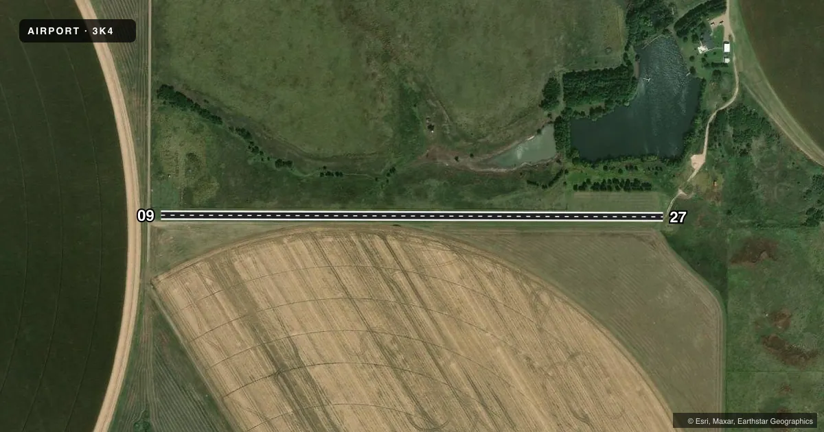
Runways & pattern
Full pagePattern entry · RWY 27
LEFT TRAFFICAirport sketch
Runways drawn to scale from FAA survey coordinates, rendered over satellite imagery. Not for navigation.
Approaches & charts
Services on the field
Fuel grades, oxygen, maintenance, ramp storage and lighting — as declared to the FAA by the airport operator.
Fuel & services
- Fuel
- Not available
Ramp & ground
- Transient storage
- Not published
Fuel & FBOs
Cheapest 100LL and Jet A on the field and nearby. Always confirm with the FBO before taxi.
Airport notes
Surface conditions, obstructions, local procedures, lighting outages and other notes published with each FAA cycle.
Other notes
- MANAGERHAYDENBORTH1@GMAIL.COM
VFR map & nearby airports
VFR sectional. Tap any ICAO chip to open that airport.
Key facts · 3K4
Answer card- ICAO
- 3K4
- Name
- BORTH FLD
- Location
- MEADE, KANSAS
- Elevation
- 2,707 ft MSL
- Traffic pattern altitude
- 3,707 ft MSL (1,000 AGL)
- Control tower
- Non-towered (use CTAF)
- Total runways
- 1
- Longest runway
- 09/27 · 2,282 ft
- Published ILS approaches
- 0
- Published frequencies
- 0
- Magnetic variation
- –
- Current flight rules
- VFR
- Current wind
- 200° at 10 kt
- Favored runway now
- RWY 27
Borth Fld sits in Meade, Kansas. The field elevation is 2,707 ft MSL. It has one runway, 09/27, which is 2,282 ft long and turf. The airport is non-towered. No ILS approaches are published here.
Pattern altitude is not published in the facts. Use the standard 1,000 ft AGL pattern unless the current Chart Supplement says otherwise. At this elevation, expect a little less performance than you would at a lowland strip. That matters on a short turf runway. There are no on-field FBOs listed in the facts. Contact the airport manager directly at HAYDENBORTH1@GMAIL.COM before arrival if you need current field information.
Published remarks note the airport manager contact only. For anything not shown here, such as local procedures, lighting status, or any current operating notes, check the current FAA Chart Supplement before you go.