METAR & TAF 4KS
4KS does not publish a METAR.
Showing the nearest reporting station: KAVK (ALVA RGNL) · 17.0 NM away. Conditions at 4KS may differ.
METAR · KAVK
Observed 06:15Z
KAVK 270615Z AUTO 19008KT 10SM CLR 30/18 A2986 RMK A01
- Wind
- 190° @ 8 kt
- Visibility
- 10 SM
- Temp / Dew
- 30°C / 18°C
- Altimeter
- 29.86 inHg
- Clouds
- CLR
- Density alt
- 3,594 ft
- Ceiling
- Unlimited
- Rules
- VFR
Airport info & contacts
Manager on record, flight service, ARTCC, attendance schedule and pattern altitude — published by the FAA and refreshed every 28 days.
Location
- From city
- 4 NM NW
- VFR sectional
- WICHITA
- ARTCC
- ZKC · KANSAS CITY
- NOTAM facility
- ICT (NOTAM-D)
Airport manager
- Name
- STEVEN E. WALZ
- Phone
- (620) 825-4643
- Address
- 17535 SE U.S. HWY 281, MILE 7, KIOWA KS 67070
Flight service · Hours
- FSS ICT
- WICHITA1-800-WX-BRIEF
- Attendance
- ALL
Frequencies
Tap any row to copy the frequency to your clipboard.
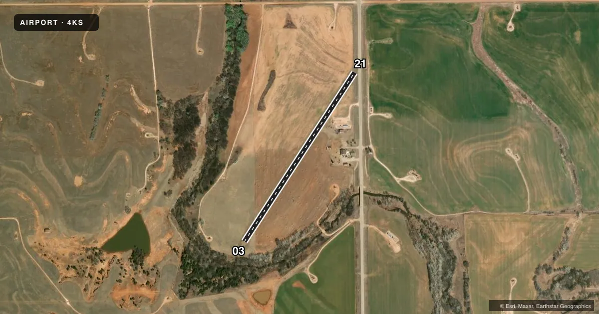
Runways & pattern
Full pagePattern entry · RWY 21
LEFT TRAFFICRunway end performance
| End | TORA | TODA | ASDA | LDA | VGSI | Approach lights | Obstruction |
|---|---|---|---|---|---|---|---|
| 03 | — | — | — | — | — | — | 45', trees, 150' from thr, 75' R of cntrln, slope 3 |
| 21 | — | — | — | — | — | — | 5', fence, 0' from thr, 0' R of cntrln, slope 0 |
Declared distances in feet. TORA = takeoff run available, TODA = takeoff distance, ASDA = accelerate-stop, LDA = landing distance.
Airport sketch
Runways drawn to scale from FAA survey coordinates, rendered over satellite imagery. Not for navigation.
Approaches & charts
Services on the field
Fuel grades, oxygen, maintenance, ramp storage and lighting — as declared to the FAA by the airport operator.
Fuel & services
- Fuel
- 100LL
- Oxygen (bottled)
- Not available
- Oxygen (bulk)
- Not available
- Airframe repair
- Not available
- Power plant repair
- Not available
Ramp & ground
- Transient storage
- Not published
- Landing fee
- Yes
- Lighting schedule
- SS-SR
- Beacon schedule
- SS-SR
- Beacon
- White(W)
- Wind indicator
- Yes
- Segmented circle
- No
Fuel & FBOs
Cheapest 100LL and Jet A on the field and nearby. Always confirm with the FBO before taxi.
Airport notes
Surface conditions, obstructions, local procedures, lighting outages and other notes published with each FAA cycle.
General notes
- 195 FT TWR NEAR MIDFIELD APRX 375 FT EAST OF RY CNTRLN.
- 19 FT OIL WELL PUMP NEAR MIDFIELD APRX 375 FT EAST OF RY CNTRLN.
- WIND SOCK ON 38 FT SILO 375 FT LEFT AT MID FIELD RY 23.
- NSTD DSPLCD THLD MARKINGS (TFC CONES).
- RWY 3/21 TURF UNEVEN DUE TO GOPHER HOLES
- BIRD AND WILDLIFE ACT NEAR ARPT
- 17:1 APCH SLOPE TO LIGHTED OIL TANK 550' FROM DSPLCD THLD R/W 21
- FOR CD CTC KANSAS CITY ARTCC AT 913-254-8508.
- NUMEROUS OBST, POLES, OIL WELL AND BLDG EAST OF FIELD
Fuel notes
- 100LLONLY FOR EMERGENCY USE
Approach & departure obstructions
- 03RWY 3/21 MKD WITH 4' MKR CONES EVERY 300' A POTENTIAL LOW WING ACFT HAZ
- 03RY 03 APCH SLOPE 10:1 DUE TO 45 FT TREES 450 FT FM THE DSPLCD THLD.
- 21CONTROLLING OBSTN EXCEEDS A 45 DEG SLP.
Other notes
- FEE FOR AG OPERATORS
- WINDCONE ON SILO MIDFIELD APRX 110 FT EAST OF RWY CNTRLN. AND ON OIL TANK 400' EAST OF FIELD
VFR map & nearby airports
VFR sectional. Tap any ICAO chip to open that airport.
Key facts · 4KS
Answer card- ICAO
- 4KS
- Name
- WALZ
- Location
- KIOWA, KANSAS
- Elevation
- 1,387 ft MSL
- Traffic pattern altitude
- 2,387 ft MSL (1,000 AGL)
- Control tower
- Non-towered (use CTAF)
- Total runways
- 1
- Longest runway
- 03/21 · 2,525 ft
- Published ILS approaches
- 0
- Published frequencies
- 2
- Magnetic variation
- –
- Current flight rules
- VFR
- Current wind
- 190° at 8 kt
- Favored runway now
- RWY 21
WALZ (4KS) sits near Kiowa, Kansas. Field elevation is 1,387 ft MSL. The airport has one runway. Runway 03/21 is 2,525 ft of turf. No control tower is published. CTAF and UNICOM are both 122.8. No ILS approaches are published.
The pattern altitude is not published. Use the standard 1,000 ft AGL pattern unless the current Chart Supplement says otherwise. The field has several items a first-time pilot should plan around. Published remarks note uneven turf from gopher holes. There is also a 195-foot tower near midfield east of the runway centerline. A 19-foot oil well pump sits near midfield too. Marker cones are used on the runway. Low-wing pilots should keep a sharp scan on rollout and taxi. Bird and wildlife activity is also reported.
Runway 03 has a steep approach path because of trees near the displaced threshold. Runway 21 also has a published approach slope note. There are numerous obstructions east of the field, including poles, oil wells and buildings. For clearance delivery, contact Kansas City ARTCC at 913-254-8508. If you are planning a first stop here, verify current field condition and any local operating notes with the airport operator before departure.