METAR & TAF KDDC
Current METAR
Observed 05:52Z
KDDC 270552Z AUTO 19010KT 9SM CLR 28/15 A2989 RMK AO2 SLP079 T02830150 10378 20283 403940250 51004 $
- Wind
- 190° @ 10 kt
- Visibility
- 9 SM
- Temp / Dew
- 28°C / 15°C
- Altimeter
- 29.89 inHg
- Clouds
- CLR
- Density alt
- 4,816 ft
- Ceiling
- Unlimited
- Rules
- VFR
Airport info & contacts
Manager on record, flight service, ARTCC, attendance schedule and pattern altitude — published by the FAA and refreshed every 28 days.
Location
- From city
- 3 NM E
- VFR sectional
- WICHITA
- ARTCC
- ZKC · KANSAS CITY
- NOTAM facility
- DDC (NOTAM-D)
Airport manager
- Name
- MR ELIEL MARIN
- Phone
- 620-225-8280
- Address
- 100 AIRPORT RD, DODGE CITY KS 67801
Flight service · Hours
- FSS ICT
- WICHITA1-800-WX-BRIEF
- Attendance
- 0600-2200
Frequencies
Tap any row to copy the frequency to your clipboard.
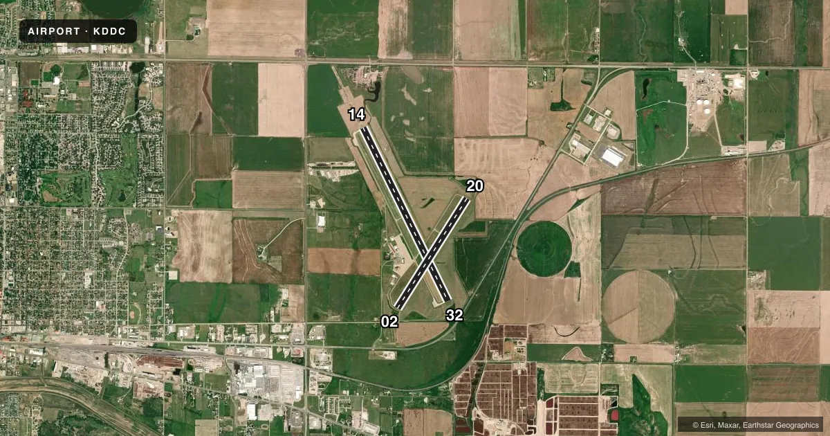
Runways & pattern
Full pagePattern entry · RWY 20
LEFT TRAFFIC| Runway | Heading (°M) | Length | Surface | Traffic |
|---|---|---|---|---|
| 14/32 | 146° / 326° | 6,899 ft | ASPH | Standard L |
| 02/20Favored | 24° / 204° | 4,650 ft | ASPH | Standard L |
Runway end performance
| End | TORA | TODA | ASDA | LDA | VGSI | Approach lights | Obstruction |
|---|---|---|---|---|---|---|---|
| 14 | 6,899' | 6,899' | 6,329' | 6,329' | VASI 4-box left(3°) | MALSR | — |
| 32 | 6,899' | 6,899' | 6,899' | 6,329' | VASI 4-box left(3°) | — | — |
| 02 | 4,650' | 4,650' | 4,650' | 4,650' | PAPI 4-box left(3°) | — | — |
| 20 | 4,650' | 4,650' | 4,650' | 4,650' | PAPI 4-box left(3°) | — | — |
Declared distances in feet. TORA = takeoff run available, TODA = takeoff distance, ASDA = accelerate-stop, LDA = landing distance.
Airport sketch
Runways drawn to scale from FAA survey coordinates, rendered over satellite imagery. Not for navigation.
Approaches & charts
ILS · 1
Services on the field
Fuel grades, oxygen, maintenance, ramp storage and lighting — as declared to the FAA by the airport operator.
Fuel & services
- Fuel
- 100LLA
- Oxygen (bottled)
- Not available
- Oxygen (bulk)
- Low pressure
- Airframe repair
- Major
- Power plant repair
- Major
- Other services
- AGRI,AMB,CHTR,INSTR,RNTL,SALES
Ramp & ground
- Transient storage
- Tie-down
- Hangar
- Landing fee
- No fee published
- Customs
- Not available
- Lighting schedule
- SEE RMK
- Beacon schedule
- SS-SR
- Beacon
- White / Green (civil land)(WG)
- Wind indicator
- Lighted
- Segmented circle
- Yes
Fuel & FBOs
Cheapest 100LL and Jet A on the field and nearby. Always confirm with the FBO before taxi.
Airport notes
Surface conditions, obstructions, local procedures, lighting outages and other notes published with each FAA cycle.
General notes
- RWY ENDS 02 & 20 NOT VSB FM OPPOSITE ENDS.
- FOR CD IF UNA TO CTC ON FSS FREQ, CTC KANSAS CITY ARTCC AT 913-254-8508.
- TWY B BTN E SIDE RWY 14/32 & APCH END RWY 20, TWY B SOUTH END OF S APRON & APCH APCH END OF RWY 02 & TWY B1 UNUSBL BY ACR.
Lighting notes
- DUSK-DAWN. ACTVT MALSR RWY 14; REIL RWY 32; PAPI RWY 02 & 20, VASI RWY 14 & 32; MIRL RWY 14/32 & 02/20 - CTAF
Runway surface & condition
- 02/20PCR VALUE: 140/R/D/W/T
- 14/32PCR VALUE: 320/R/D/W/T
- 02/20RWY 02/20 NOT AVBL FOR PART 121/PART 380 OPS WITH SKED PAX CARRYING OPS MORE THAN 9 PAX SEATS AND NON-SKED PAX CARRYING OPS MORE THAN 30 PAX SEATS.
Other notes
- ARFF INDEX B EQUIPMENT IS PROVIDED. 24 HRS PPR FOR UNSKED ACR OPNS WITH MORE THAN 30 PASSENGER SEATS; CALL FORD COUNTY COMMUNICATIONS AT 620-227-4646.
VFR map & nearby airports
VFR sectional. Tap any ICAO chip to open that airport.
Key facts · KDDC
Answer card- ICAO
- KDDC
- Name
- DODGE CITY RGNL
- Location
- DODGE CITY, KANSAS
- Elevation
- 2,595.5 ft MSL
- Traffic pattern altitude
- 3,595.5 ft MSL (1,000 AGL)
- Control tower
- Non-towered (use CTAF)
- Total runways
- 2
- Longest runway
- 14/32 · 6,899 ft
- Published ILS approaches
- 1
- Published frequencies
- 2
- Magnetic variation
- 8°
- Current flight rules
- VFR
- Current wind
- 190° at 10 kt
- Favored runway now
- RWY 20
Dodge City Rgnl sits in Dodge City, Kansas. Field elevation is 2,595.5 ft MSL. The airport has two asphalt runways. The longest is 6,899 ft on runway 14/32. This is a non-towered field. CTAF and UNICOM are both 122.7. The published pattern altitude is not listed, so use standard traffic pattern planning for light piston unless the current Chart Supplement says otherwise.
There is 1 ILS approach. It serves runway 14. That matters here because the field also has runway lighting from dusk to dawn. Runway 14 has malfunctioning approach lighting system with runway alignment indicator lights. Runway 32 has runway end identifier lights. PAPI is on runways 02 and 20. VASI is on runways 14 and 32. Crotts Aircraft Service is on the field. It carries 100LL and Jet A. Call ahead at (620) 227-3553 for current availability and ramp details.
A few operational notes matter for a first-time arrival. Runway 02/20 has weight and tire limits. It is not available for some Part 121 and Part 380 passenger operations. Taxiway B, taxiway B1 and parts of the south apron area are unusable by aircraft. Runway ends 02 and 20 are not visible from opposite ends. If you need clearance delivery help, the published remarks point pilots to Kansas City ARTCC when Flight Service cannot be reached. Check the current Chart Supplement for any airport-specific restrictions before you go.