METAR & TAF KHHF
Current METAR
Observed 15:55Z
KHHF 271555Z AUTO 23011G14KT 10SM CLR 38/13 A2992 RMK AO2
- Wind
- 230° @ 11G14 kt
- Visibility
- 10 SM
- Temp / Dew
- 38°C / 13°C
- Altimeter
- 29.92 inHg
- Clouds
- CLR
- Density alt
- 5,732 ft
- Ceiling
- Unlimited
- Rules
- VFR
Airport info & contacts
Manager on record, flight service, ARTCC, attendance schedule and pattern altitude — published by the FAA and refreshed every 28 days.
Location
- From city
- 2 NM SW
- VFR sectional
- DALLAS-FT WORTH
- ARTCC
- ZAB · ALBUQUERQUE
- NOTAM facility
- HHF (NOTAM-D)
Airport manager
- Name
- BILL KENDALL
- Phone
- 806-679-4774
- Address
- 255 AIRPORT ROAD - PO BOX 96, CANADIAN TX 79014
Flight service · Hours
- FSS FTW
- FORT WORTH1-800-WX-BRIEF
- Attendance
- MON-FRI · 0800-1700
Frequencies
Tap any row to copy the frequency to your clipboard.
Runways & pattern
Full pagePattern entry · RWY 22
RIGHT TRAFFIC| Runway | Heading (°M) | Length | Surface | Traffic |
|---|---|---|---|---|
| 04/22Favored | 38° / 218° | 5,004 ft | ASPH | 22 R |
| 18/36 | 179° / 359° | 3,001 ft | ASPH | 18 R |
Runway end performance
| End | TORA | TODA | ASDA | LDA | VGSI | Approach lights | Obstruction |
|---|---|---|---|---|---|---|---|
| 04 | — | — | — | — | PAPI 2-box left(3°) | — | 8', fence, 390' from thr, 0' R of cntrln, slope 23 |
| 22 | — | — | — | — | PAPI 2-box left(3°) | — | 46', trees, 1417' from thr, 0' R of cntrln, slope 26 |
| 18 | — | — | — | — | — | — | 10', road, 210' from thr, 126' R of cntrln, slope 1 |
| 36 | — | — | — | — | — | — | 6', fence, 212' from thr, 0' R of cntrln, slope 2 |
Declared distances in feet. TORA = takeoff run available, TODA = takeoff distance, ASDA = accelerate-stop, LDA = landing distance.
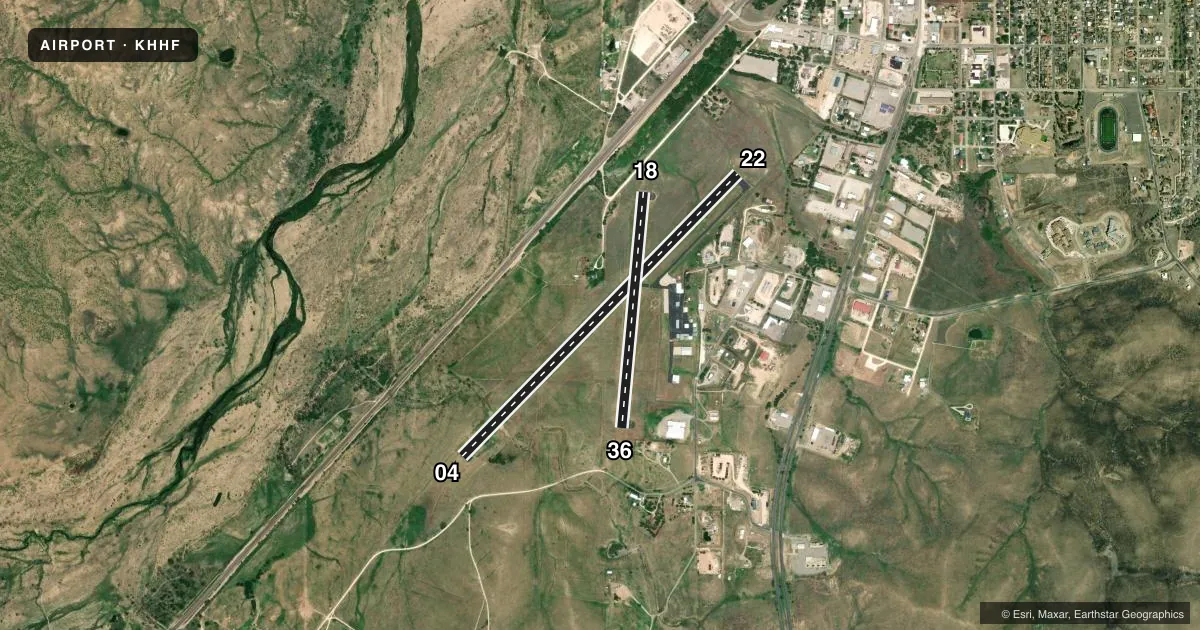
Airport sketch
Runways drawn to scale from FAA survey coordinates, rendered over satellite imagery. Not for navigation.
Approaches & charts
Services on the field
Fuel grades, oxygen, maintenance, ramp storage and lighting — as declared to the FAA by the airport operator.
Fuel & services
- Fuel
- 100LLAA++10
- Oxygen (bottled)
- Not available
- Oxygen (bulk)
- Not available
Ramp & ground
- Transient storage
- Tie-down
- Hangar
- Landing fee
- No fee published
- Customs
- Not available
- Lighting schedule
- SEE RMK
- Beacon schedule
- SS-SR
- Beacon
- White / Green (civil land)(WG)
- Wind indicator
- Lighted
- Segmented circle
- Yes
Fuel & FBOs
Cheapest 100LL and Jet A on the field and nearby. Always confirm with the FBO before taxi.
Airport notes
Surface conditions, obstructions, local procedures, lighting outages and other notes published with each FAA cycle.
General notes
- 15 FT DITCH N OF RWY 04 THR EXTDG 1000 FT ALG LEFT SIDE OF RWY.
- FOR CD CTC ALBUQUERQUE ARTCC AT 505-856-4861.
Lighting notes
- DUSK-DAWN. MIRL RWY 04/22 AND RWY 18/36 PRESET LOW INTST; TO INCR INTST ACTVT - CTAF.
VFR map & nearby airports
VFR sectional. Tap any ICAO chip to open that airport.
Key facts · KHHF
Answer card- ICAO
- KHHF
- Name
- HEMPHILL COUNTY
- Location
- CANADIAN, TEXAS
- Elevation
- 2,396.4 ft MSL
- Traffic pattern altitude
- 3,396.4 ft MSL (1,000 AGL)
- Control tower
- Non-towered (use CTAF)
- Total runways
- 2
- Longest runway
- 04/22 · 5,004 ft
- Published ILS approaches
- 0
- Published frequencies
- 1
- Magnetic variation
- 6°
- Current flight rules
- VFR
- Current wind
- 230° at 11 kt
- Favored runway now
- RWY 22
Hemphill County Airport sits in Canadian, Texas. The field elevation is 2,396.4 ft MSL. It has two asphalt runways. The longest is runway 04/22 at 5,004 ft. There is no control tower. CTAF is 122.9.
No ILS approaches are published here. Pattern altitude is not published in the facts, so use the standard 1,000 ft AGL for light piston traffic unless the current FAA Chart Supplement says otherwise. That puts the pattern around 3,396 ft MSL based on the listed field elevation, but verify before you fly.
The on-field FBO is Hemphill County Airport. It carries 100LL and Jet A Prist. Call (806) 679-4774 for current services and ramp details. Published remarks note a 15-foot ditch north of the runway 04 threshold that runs along the left side for about 1,000 ft. That is worth planning for on arrival and departure from that end. Lighting is medium intensity on both runways from dusk to dawn. The lights come up from low intensity when activated on CTAF.
This is a non-towered field in open country. Watch your spacing and make your calls early. For clearance delivery, contact Albuquerque ARTCC at 505-856-4861. Check the current FAA Chart Supplement for any other local procedures before flying in.