METAR & TAF 1X1
1X1 does not publish a METAR.
Showing the nearest reporting station: KGAG (GAGE) · 16.6 NM away. Conditions at 1X1 may differ.
METAR · KGAG
Observed 17:53Z
KGAG 271753Z AUTO 20007KT 10SM CLR 39/16 A2990 RMK AO2 SLP086 T03890156 10389 20233 56008
- Wind
- 200° @ 7 kt
- Visibility
- 10 SM
- Temp / Dew
- 39°C / 16°C
- Altimeter
- 29.90 inHg
- Clouds
- CLR
- Density alt
- 6,086 ft
- Ceiling
- Unlimited
- Rules
- VFR
Airport info & contacts
Manager on record, flight service, ARTCC, attendance schedule and pattern altitude — published by the FAA and refreshed every 28 days.
Location
- From city
- 1 NM S
- VFR sectional
- WICHITA
- ARTCC
- ZKC · KANSAS CITY
- NOTAM facility
- FTW (NOTAM-D)
Airport manager
- Name
- DAN COCKRELL
- Phone
- 806-862-4131
- Address
- COUNTY COURTHOUSE, 101 S. MAIN, LIPSCOMB TX 79056
Flight service · Hours
- FSS FTW
- FORT WORTH1-800-WX-BRIEF
- Attendance
- Unattended
Frequencies
Tap any row to copy the frequency to your clipboard.
Runways & pattern
Full pagePattern entry · RWY 18
LEFT TRAFFICRunway end performance
| End | TORA | TODA | ASDA | LDA | VGSI | Approach lights | Obstruction |
|---|---|---|---|---|---|---|---|
| 18 | — | — | — | — | — | — | 28', trees, 395' from thr, 30' R of cntrln, slope 6 |
Declared distances in feet. TORA = takeoff run available, TODA = takeoff distance, ASDA = accelerate-stop, LDA = landing distance.
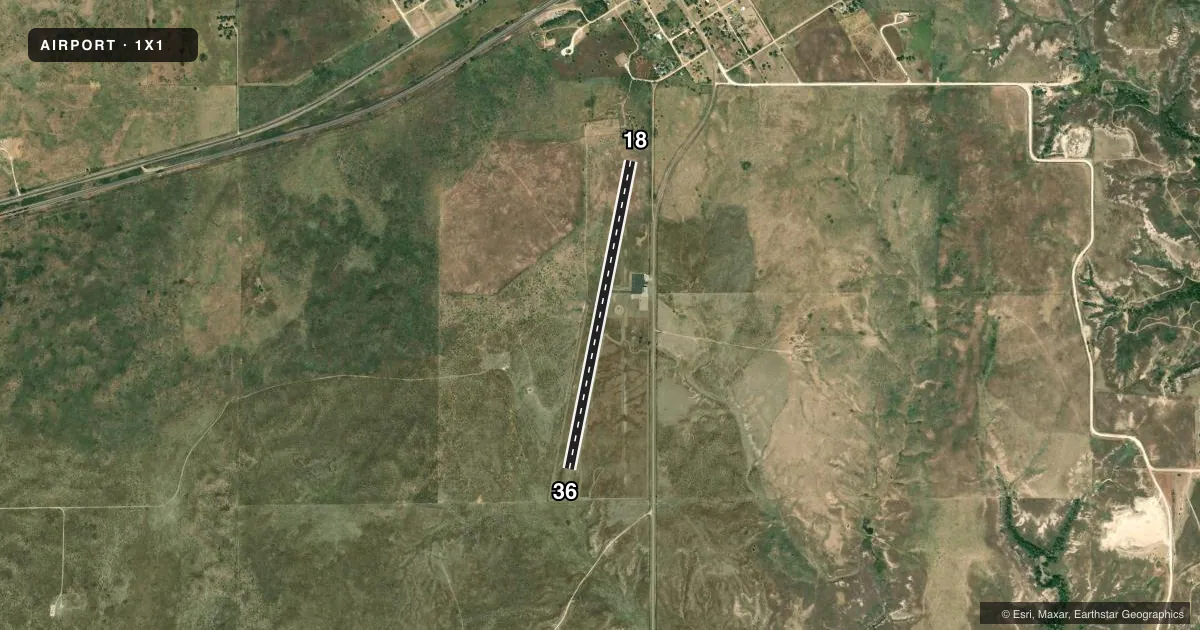
Airport sketch
Runways drawn to scale from FAA survey coordinates, rendered over satellite imagery. Not for navigation.
Approaches & charts
Services on the field
Fuel grades, oxygen, maintenance, ramp storage and lighting — as declared to the FAA by the airport operator.
Fuel & services
- Fuel
- Not available
- Oxygen (bottled)
- Not available
- Oxygen (bulk)
- Not available
- Airframe repair
- Not available
- Power plant repair
- Not available
Ramp & ground
- Transient storage
- Tie-down
- Landing fee
- No fee published
- Customs
- Not available
- Wind indicator
- Yes
- Segmented circle
- No
Fuel & FBOs
Cheapest 100LL and Jet A on the field and nearby. Always confirm with the FBO before taxi.
Airport notes
Surface conditions, obstructions, local procedures, lighting outages and other notes published with each FAA cycle.
General notes
- NO LINE OF SIGHT BTN RWY ENDS.
- FOR CD CTC KANSAS CITY ARTCC AT 913-254-8508.
- 120 FT AGL WATER TWR, 2000 FT NW OF RWY 18 END, UNLGTD.
Approach & departure obstructions
- 18APCH SLOPE 21:1 AT DSPLCD THR OVR 28 FT TREES, 591 FT DSTC, 30 FT R.
- 18ALSO 30 FT UMMKD PLINE, 420 FT DSTC, 150 FT L, 7:1, 20:1 TO DSPLCD THLD.
Other notes
- THIS AIRPORT HAS BEEN SURVEYED BY THE NATIONAL GEODETIC SURVEY.
- MANAGERPCT 4 CO. COMMISSIONER.
- MANAGER806-480-4426.
- 18/36PEA STONE SURFACE SEAL, LOOSE STONES ON RWY.
VFR map & nearby airports
VFR sectional. Tap any ICAO chip to open that airport.
Key facts · 1X1
Answer card- ICAO
- 1X1
- Name
- HIGGINS/LIPSCOMB COUNTY
- Location
- HIGGINS, TEXAS
- Elevation
- 2,565.5 ft MSL
- Traffic pattern altitude
- 3,565.5 ft MSL (1,000 AGL)
- Control tower
- Non-towered (use CTAF)
- Total runways
- 1
- Longest runway
- 18/36 · 3,969 ft
- Published ILS approaches
- 0
- Published frequencies
- 1
- Magnetic variation
- 8°
- Current flight rules
- VFR
- Current wind
- 200° at 7 kt
- Favored runway now
- RWY 18
Higgins/Lipscomb County Airport sits in Higgins, Texas. The field elevation is 2,565.5 ft MSL. It has one runway, 18/36, which is 3,969 ft long and paved with asphalt. There is no control tower. CTAF is 122.9. No ILS approaches are published here.
The pattern altitude is not published. Use the standard 1,000 ft AGL pattern unless the current Chart Supplement says otherwise. That puts the light piston pattern at about 3,565.5 ft MSL. The runway headings are 191° and 11° magnetic. Magnetic variation is 8°.
There are no on-field FBOs listed in the facts, so call the airport operator directly before arrival if you need fuel or ramp details. Published remarks call out loose stones on the runway surface seal. They also note no line of sight between runway ends. Runway 18 has nearby obstruction concerns, including trees on approach and an unlighted water tower northwest of the field. This is a high-elevation airport in the Texas Panhandle, so expect performance to matter on warm days. Check density altitude before departure. If you need clearance delivery, the published contact is Kansas City Center. For any current operational detail, verify with the current FAA Chart Supplement or the airport operator.