METAR & TAF KPYX
Current METAR
Observed 14:55Z
KPYX 121455Z AUTO 19008KT 10SM OVC010 24/21 A3021 RMK AO2 T02390207
- Wind
- 190° @ 8 kt
- Visibility
- 10 SM
- Temp / Dew
- 24°C / 21°C
- Altimeter
- 30.21 inHg
- Clouds
- OVC
- Density alt
- 4,339 ft
- Ceiling
- 1,000 ft AGL
- Rules
- MVFR
Airport info & contacts
Manager on record, flight service, ARTCC, attendance schedule and pattern altitude — published by the FAA and refreshed every 28 days.
Location
- From city
- 3 NM E
- VFR sectional
- WICHITA
- ARTCC
- ZKC · KANSAS CITY
- NOTAM facility
- PYX (NOTAM-D)
Airport manager
- Name
- BEAR KNOX
- Phone
- 806-435-4226
- Address
- PO BOX 709, PERRYTON TX 79070
Flight service · Hours
- FSS FTW
- FORT WORTH1-800-WX-BRIEF
- Attendance
- MON-SAT · 0800-1700
- SUN · 1300-1700
Frequencies
Tap any row to copy the frequency to your clipboard.
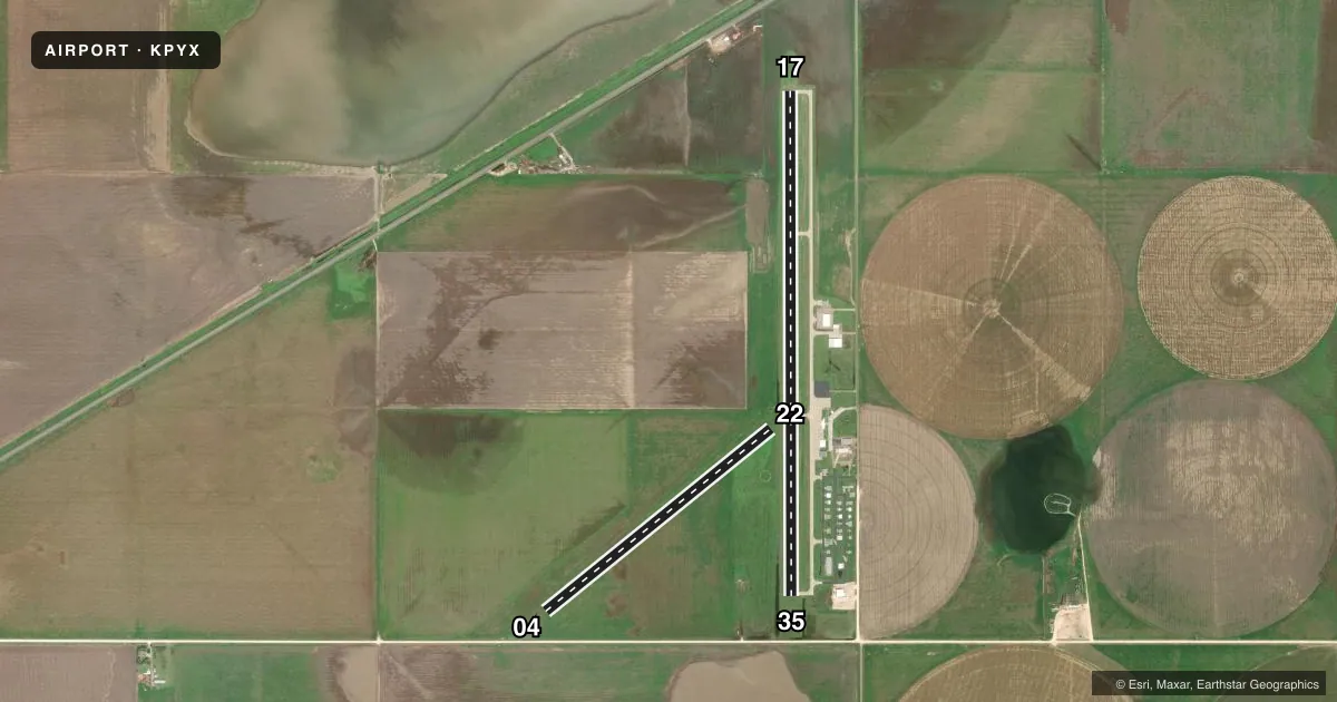
Runways & pattern
Full pagePattern entry · RWY 17
LEFT TRAFFIC| Runway | Heading (°M) | Length | Surface | Traffic |
|---|---|---|---|---|
| 17/35Favored | 173° / 353° | 5,701 ft | ASPH | Standard L |
| 04/22 | 44° / 224° | 3,280 ft | TURF | Standard L |
Runway end performance
| End | TORA | TODA | ASDA | LDA | VGSI | Approach lights | Obstruction |
|---|---|---|---|---|---|---|---|
| 17 | — | — | — | — | PAPI 4-box left(3°) | — | 23', pole, 856' from thr, 363' R of cntrln, slope 28 |
| 35 | — | — | — | — | PAPI 4-box left(3°) | — | 15', road, 500' from thr, 0' R of cntrln, slope 20 |
| 04 | — | — | — | — | — | — | 15', road, 0' from thr, 120' R of cntrln, slope 0 |
| 22 | — | — | — | — | — | — | 30', pline, 1200' from thr, 120' R of cntrln, slope 40 |
Declared distances in feet. TORA = takeoff run available, TODA = takeoff distance, ASDA = accelerate-stop, LDA = landing distance.
Airport sketch
Runways drawn to scale from FAA survey coordinates, rendered over satellite imagery. Not for navigation.
Approaches & charts
Services on the field
Fuel grades, oxygen, maintenance, ramp storage and lighting — as declared to the FAA by the airport operator.
Fuel & services
- Fuel
- 100LLA1+
- Oxygen (bottled)
- Not available
- Oxygen (bulk)
- Not available
- Airframe repair
- Major
- Power plant repair
- Major
- Other services
- AGRI
Ramp & ground
- Transient storage
- Tie-down
- Hangar
- Landing fee
- No fee published
- Customs
- Not available
- Lighting schedule
- SEE RMK
- Beacon schedule
- SS-SR
- Beacon
- White / Green (civil land)(WG)
- Wind indicator
- Lighted
- Segmented circle
- Yes
Fuel & FBOs
Cheapest 100LL and Jet A on the field and nearby. Always confirm with the FBO before taxi.
Airport notes
Surface conditions, obstructions, local procedures, lighting outages and other notes published with each FAA cycle.
General notes
- FOR CD CTC KANSAS CITY ARTCC AT 913-254-8508.
Lighting notes
- DUSK-DAWN. MIRL RWY 17/35 PRESET LOW INTST; TO INCR INTST - CTAF. PAPI RWY 17 & 35 OPR CONSLY.
Fuel notes
- 100LLFOR FUEL AFT HRS CALL 806-435-4226 OR 806-228-5573.
Runway surface & condition
- 04/22SOUTH 1000 FT CLSD INDEFLY. 2280 FT AVBL.
Approach & departure obstructions
- 179 FT SUPPLL WINDSOCK 12 FT FM THR, 187 FT RIGHT.
- 359 FT SUPPLL WINDSOCK, 44 FT DSTC, 197 FT RIGHT.
- 0415 FT. GRAVEL RD AT RWY END.
Other notes
- 04/22RWY ENDS INDEF, MKD BY MOWING. SFC ROUGH WITH LARGE ANIMAL HOLES.
VFR map & nearby airports
VFR sectional. Tap any ICAO chip to open that airport.
Key facts · KPYX
Answer card- ICAO
- KPYX
- Name
- PERRYTON OCHILTREE COUNTY
- Location
- PERRYTON, TEXAS
- Elevation
- 2,918.4 ft MSL
- Traffic pattern altitude
- 3,918.4 ft MSL (1,000 AGL)
- Control tower
- Non-towered (use CTAF)
- Total runways
- 2
- Longest runway
- 17/35 · 5,701 ft
- Published ILS approaches
- 0
- Published frequencies
- 2
- Magnetic variation
- 7°
- Current flight rules
- MVFR
- Current wind
- 190° at 8 kt
- Favored runway now
- RWY 17
Perryton Ochiltree County Airport (KPYX) sits in Perryton, Texas at 2,918.4 ft MSL. It has two runways. The longest is 17/35 at 5,701 ft. Runway 04/22 is 3,280 ft of turf. There is no control tower. CTAF and UNICOM are both 122.8.
No ILS approaches are published here. Pattern altitude is not published, so use 1,000 ft AGL for light piston traffic unless the current Chart Supplement says otherwise. The field uses magnetic variation of 7°. Knox Aviation is on the field. It carries 100LL and Jet A Prist. Call them at (806) 435-4226 for current service details.
A few published remarks matter for planning. Runway 17/35 lights are preset to low intensity from dusk to dawn. Use CTAF to raise the intensity. The PAPI on 17 and 35 runs continuously. Runway 04/22 has indefinite ends marked by mowing. The surface is rough with large animal holes, so treat it as a soft-field strip and inspect it carefully before use. There is also a 15-foot gravel road at the runway end of 04. For clearance delivery, contact Kansas City ARTCC at 913-254-8508. This is a non-towered field at higher elevation, so expect density altitude to matter in warm weather.