METAR & TAF E42
Current METAR
Observed 17:15Z
KE42 271715Z AUTO 19013KT 10SM CLR A2997 RMK AO2
- Wind
- 190° @ 13 kt
- Visibility
- 10 SM
- Temp / Dew
- —
- Altimeter
- 29.97 inHg
- Clouds
- CLR
- Density alt
- —
- Ceiling
- Unlimited
- Rules
- VFR
Airport info & contacts
Manager on record, flight service, ARTCC, attendance schedule and pattern altitude — published by the FAA and refreshed every 28 days.
Location
- From city
- 1 NM N
- VFR sectional
- WICHITA
- ARTCC
- ZAB · ALBUQUERQUE
- NOTAM facility
- FTW (NOTAM-D)
Airport manager
- Name
- JUSTIN PARKER
- Phone
- 806-659-2524
- Address
- PO BOX 37, SPEARMAN TX 79081
Flight service · Hours
- FSS FTW
- FORT WORTH1-800-WX-BRIEF
- Attendance
- Unattended
Frequencies
Tap any row to copy the frequency to your clipboard.
Runways & pattern
Full pagePattern entry · RWY 20
LEFT TRAFFICRunway end performance
| End | TORA | TODA | ASDA | LDA | VGSI | Approach lights | Obstruction |
|---|---|---|---|---|---|---|---|
| 02 | — | — | — | — | PAPI 2-box left(3°) | — | — |
| 20 | — | — | — | — | PAPI 2-box left(3°) | — | — |
Declared distances in feet. TORA = takeoff run available, TODA = takeoff distance, ASDA = accelerate-stop, LDA = landing distance.
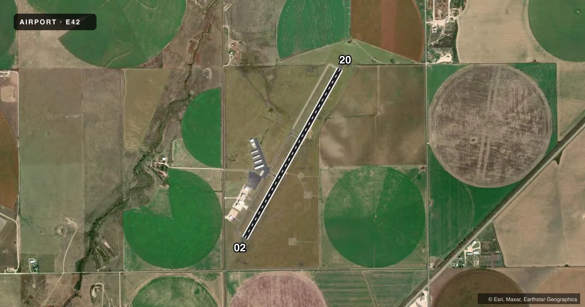
Airport sketch
Runways drawn to scale from FAA survey coordinates, rendered over satellite imagery. Not for navigation.
Approaches & charts
Services on the field
Fuel grades, oxygen, maintenance, ramp storage and lighting — as declared to the FAA by the airport operator.
Fuel & services
- Fuel
- 100LL
- Other services
- AGRI
Ramp & ground
- Transient storage
- Tie-down
- Hangar
- Landing fee
- No fee published
- Lighting schedule
- SEE RMK
- Beacon schedule
- SS-SR
- Beacon
- White / Green (civil land)(WG)
- Wind indicator
- Lighted
- Segmented circle
- Yes
Fuel & FBOs
Cheapest 100LL and Jet A on the field and nearby. Always confirm with the FBO before taxi.
Airport notes
Surface conditions, obstructions, local procedures, lighting outages and other notes published with each FAA cycle.
General notes
- NO LINE OF SIGHT BTN RWY ENDS.
- FOR CD CTC ALBUQUERQUE ARTCC AT 505-856-4861.
Lighting notes
- MIRL RWY 02/20 PRESET LOW INTST; TO INCR INTST & ACTVT PAPI RWYS 02 & 20 - 122.9. NMRS LGTS OUT, KNOCKED OVER, MISSING, INCORRECT COLORS, OUT OF ALIGNMENT. CALL TO CHECK OPR STATUS.
Fuel notes
- 100LLFOR FUEL CALL 806-659-2422 & HGR SPACE 806-659-2524 MON-SAT 0730-1900.
Approach & departure obstructions
- 02MKGS FADED
- 20MKGS FADED.
- 02PAPI OTS
Other notes
- THIS AIRPORT HAS BEEN SURVEYED BY THE NATIONAL GEODETIC SURVEY.
- MANAGERPUBLIC WORKS DIR. ADD'L CTC, CITY SECRETARY CHERYL GIBSON-SALGADO.
- 02/20NMRS CRACKS IN PAVEMENT.
VFR map & nearby airports
VFR sectional. Tap any ICAO chip to open that airport.
Key facts · E42
Answer card- ICAO
- E42
- Name
- MAJOR SAMUEL B CORNELIUS FLD
- Location
- SPEARMAN, TEXAS
- Elevation
- 3,090 ft MSL
- Traffic pattern altitude
- 4,090 ft MSL (1,000 AGL)
- Control tower
- Non-towered (use CTAF)
- Total runways
- 1
- Longest runway
- 02/20 · 5,022 ft
- Published ILS approaches
- 0
- Published frequencies
- 1
- Magnetic variation
- 9°
- Current flight rules
- VFR
- Current wind
- 190° at 13 kt
- Favored runway now
- RWY 20
MAJOR SAMUEL B CORNELIUS FLD sits in Spearman, Texas. The field elevation is 3,090 ft MSL. It has one runway, 02/20, which is 5,022 ft long with asphalt pavement. There is no control tower. CTAF is 122.9. No ILS approaches are published here.
Pattern altitude is not published. Use the standard 1,000 ft AGL pattern for light piston traffic unless the current FAA Chart Supplement or local procedures say otherwise. The on-field FBO is Cornelius Field. It carries 100LL. Call ahead before you go. The published remarks also say runway lighting on 02/20 is preset to low intensity. Use 122.9 to raise the lights and activate the PAPI. The runway environment has several reported lighting issues, so verify status before night work. Runway pavement also has numerous cracks. Markings on both ends are reported as faded. There is no line of sight between runway ends, so keep your scan tight in the pattern.
This is a non-towered field with a single runway and no published ILS. For clearance delivery, the published contact is Albuquerque ARTCC. The airport sits in the Texas Panhandle, so expect a wide-open, rural arrival with limited visual cues near the field. Check the current FAA Chart Supplement for any changes before you fly in.