METAR & TAF KGUY
Current METAR
Observed 15:53Z
KGUY 271553Z AUTO 21013KT 10SM CLR 37/14 A2993 RMK AO2 SLP069 T03670139
- Wind
- 210° @ 13 kt
- Visibility
- 10 SM
- Temp / Dew
- 37°C / 14°C
- Altimeter
- 29.93 inHg
- Clouds
- CLR
- Density alt
- 6,503 ft
- Ceiling
- Unlimited
- Rules
- VFR
Airport info & contacts
Manager on record, flight service, ARTCC, attendance schedule and pattern altitude — published by the FAA and refreshed every 28 days.
Location
- From city
- 1 NM W
- VFR sectional
- WICHITA
- ARTCC
- ZKC · KANSAS CITY
- NOTAM facility
- GUY (NOTAM-D)
Airport manager
- Name
- GREGG R DOWNING
- Phone
- 580-338-7700
- Address
- PO BOX 1510, GUYMON OK 73942
Flight service · Hours
- FSS MLC
- MC ALESTER1-800-WX-BRIEF
- Attendance
- MON-SAT · 0700-1800
- SUN · 0800-1700
Frequencies
Tap any row to copy the frequency to your clipboard.
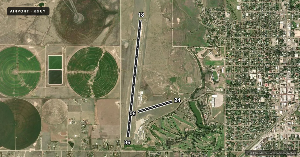
Runways & pattern
Full pagePattern entry · RWY 18
RIGHT TRAFFIC| Runway | Heading (°M) | Length | Surface | Traffic |
|---|---|---|---|---|
| 18/36Favored | 177° / 357° | 5,904 ft | ASPH | 18 R |
| 06/24 | 65° / 245° | 1,795 ft | TURF | Standard L |
Runway end performance
| End | TORA | TODA | ASDA | LDA | VGSI | Approach lights | Obstruction |
|---|---|---|---|---|---|---|---|
| 18 | — | — | — | — | VASI 4-box left(3°) | ODALS | — |
| 36 | — | — | — | — | PAPI 4-box left(3°) | — | 19', tree, 368' from thr, 156' R of cntrln, slope 8 |
Declared distances in feet. TORA = takeoff run available, TODA = takeoff distance, ASDA = accelerate-stop, LDA = landing distance.
Airport sketch
Runways drawn to scale from FAA survey coordinates, rendered over satellite imagery. Not for navigation.
Approaches & charts
Services on the field
Fuel grades, oxygen, maintenance, ramp storage and lighting — as declared to the FAA by the airport operator.
Fuel & services
- Fuel
- 100LLA+
- Oxygen (bottled)
- Not available
- Oxygen (bulk)
- HIGH/LOW
- Airframe repair
- Major
- Power plant repair
- Major
- Other services
- AGRI,AMB,CARGO,INSTR,RNTL
Ramp & ground
- Transient storage
- Tie-down
- Hangar
- Landing fee
- No fee published
- Customs
- Not available
- Lighting schedule
- SEE RMK
- Beacon schedule
- SS-SR
- Beacon
- White / Green (civil land)(WG)
- Wind indicator
- Lighted
- Segmented circle
- Yes
Fuel & FBOs
Cheapest 100LL and Jet A on the field and nearby. Always confirm with the FBO before taxi.
Airport notes
Surface conditions, obstructions, local procedures, lighting outages and other notes published with each FAA cycle.
General notes
- ARPT COURTESY CAR AVBL.
- NUMEROUS WATERFOWL INVOF ARPT SR & SS.
- FOR CD CTC KANSAS CITY ARTCC AT 913-254-8508.
- OCNL DEER ON AND IN VCNTY OF RWY
Lighting notes
- ACTVT ODALS RWY 18; VASI RWY 18; PAPI RWY 36; MIRL RWY 18/36 - CTAF. MIRL RWY 18/36 PRESET LOW INTST, INCR INTST - CTAF.
Runway surface & condition
- 18/36PCR VALUE: 130/F/D/X/T
- 06/24RWY 06 DEP NA.
Approach & departure obstructions
- 06EDGES MARKED W/ RAISED WOODEN MRKRS.
Other notes
- 1FOR ATTENDANT AFT HRS CALL 580-338-0481/7700.
VFR map & nearby airports
VFR sectional. Tap any ICAO chip to open that airport.
Key facts · KGUY
Answer card- ICAO
- KGUY
- Name
- GUYMON MUNI
- Location
- GUYMON, OKLAHOMA
- Elevation
- 3,125.4 ft MSL
- Traffic pattern altitude
- 4,125.4 ft MSL (1,000 AGL)
- Control tower
- Non-towered (use CTAF)
- Total runways
- 2
- Longest runway
- 18/36 · 5,904 ft
- Published ILS approaches
- 0
- Published frequencies
- 2
- Magnetic variation
- 9°
- Current flight rules
- VFR
- Current wind
- 210° at 13 kt
- Favored runway now
- RWY 18
Guymon Muni sits in Guymon, Oklahoma. Field elevation is 3,125.4 ft MSL. The airport has two runways. The longest is 18/36 at 5,904 ft. Runway 06/24 is turf at 1,795 ft. There is no control tower. CTAF and UNICOM are both 122.7.
No ILS approaches are published here. Pattern altitude is not published, so use the standard 1,000 ft AGL for light piston traffic unless the current FAA Chart Supplement says otherwise. The field has published lighting on runway 18/36. Runway 18 has approach lighting and a visual approach slope indicator. Runway 36 has a precision approach path indicator. The runway lights for 18 and 36 are medium intensity and are controlled on CTAF.
Centerline Aviation is on the field. It carries 100LL and Jet A. If you need an attendant after hours, the published remarks give a phone number. Runway 06 departures are not authorized. The runway 06 edges are marked with raised wooden markers. Waterfowl are reported near the airport at sunrise and sunset, so plan your arrival and departure with that in mind. The pavement classification rating for runway 18/36 is published as 130/F/D/X/T. For clearance delivery, contact Kansas City ARTCC. Check the current FAA Chart Supplement for any updates before you go.