METAR & TAF KHQG
Current METAR
Observed 16:15Z
KHQG 271615Z AUTO 21009KT 10SM CLR 36/16 A2994 RMK AO2
- Wind
- 210° @ 9 kt
- Visibility
- 10 SM
- Temp / Dew
- 36°C / 16°C
- Altimeter
- 29.94 inHg
- Clouds
- CLR
- Density alt
- 6,382 ft
- Ceiling
- Unlimited
- Rules
- VFR
Airport info & contacts
Manager on record, flight service, ARTCC, attendance schedule and pattern altitude — published by the FAA and refreshed every 28 days.
Location
- From city
- 2 NM SW
- VFR sectional
- WICHITA
- ARTCC
- ZKC · KANSAS CITY
- NOTAM facility
- ICT (NOTAM-D)
Airport manager
- Name
- SCOTT SPIKES
- Phone
- 620-544-7600
- Address
- BOX 130, HUGOTON KS 67951
Flight service · Hours
- FSS ICT
- WICHITA1-800-WX-BRIEF
- Attendance
- MON-SAT · 0800-1700
Frequencies
Tap any row to copy the frequency to your clipboard.
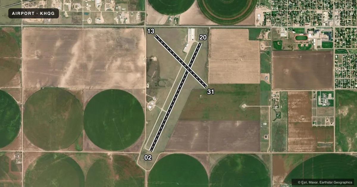
Runways & pattern
Full pagePattern entry · RWY 20
LEFT TRAFFIC| Runway | Heading (°M) | Length | Surface | Traffic |
|---|---|---|---|---|
| 02/20Favored | 20° / 200° | 5,000 ft | CONC | Standard L |
| 13/31 | 130° / 310° | 3,039 ft | ASPH | Standard L |
Runway end performance
| End | TORA | TODA | ASDA | LDA | VGSI | Approach lights | Obstruction |
|---|---|---|---|---|---|---|---|
| 02 | — | — | — | — | PAPI 2-box left(3°) | — | 17', road, 758' from thr, 0' R of cntrln, slope 32 |
| 20 | — | — | — | — | PAPI 2-box left(3°) | — | 15', road, 613' from thr, 316' R of cntrln, slope 27 |
| 13 | — | — | — | — | — | — | 17', road, 503' from thr, 0' R of cntrln, slope 17 |
Declared distances in feet. TORA = takeoff run available, TODA = takeoff distance, ASDA = accelerate-stop, LDA = landing distance.
Airport sketch
Runways drawn to scale from FAA survey coordinates, rendered over satellite imagery. Not for navigation.
Approaches & charts
Services on the field
Fuel grades, oxygen, maintenance, ramp storage and lighting — as declared to the FAA by the airport operator.
Fuel & services
- Fuel
- 100LL
- Oxygen (bottled)
- Not available
- Oxygen (bulk)
- Not available
- Airframe repair
- Not available
- Power plant repair
- Not available
- Other services
- AGRI,INSTR
Ramp & ground
- Transient storage
- Tie-down
- Hangar
- Landing fee
- No fee published
- Customs
- Not available
- Lighting schedule
- SEE RMK
- Beacon schedule
- SS-SR
- Beacon
- White / Green (civil land)(WG)
- Wind indicator
- Lighted
- Segmented circle
- Yes
Fuel & FBOs
Cheapest 100LL and Jet A on the field and nearby. Always confirm with the FBO before taxi.
Airport notes
Surface conditions, obstructions, local procedures, lighting outages and other notes published with each FAA cycle.
General notes
- FOR CD CTC KANSAS CITY ARTCC AT 913-254-8508.
Lighting notes
- ACTVT PAPI RWYS 02 & 20; HIRL RWY 02/20 - CTAF.
Other notes
- THIS AIRPORT HAS BEEN SURVEYED BY THE NATIONAL GEODETIC SURVEY.
- MAINT APCHS 20:1 GLIDE SLOPE; TRSNL SFC FOR 7:1 SLOPE; AND REMOVE 13' BLDG LOCATED 100' FM RWY 31 THR AND 30' LEFT OF CNTRLN.
VFR map & nearby airports
VFR sectional. Tap any ICAO chip to open that airport.
Key facts · KHQG
Answer card- ICAO
- KHQG
- Name
- HUGOTON MUNI
- Location
- HUGOTON, KANSAS
- Elevation
- 3,134.3 ft MSL
- Traffic pattern altitude
- 4,134.3 ft MSL (1,000 AGL)
- Control tower
- Non-towered (use CTAF)
- Total runways
- 2
- Longest runway
- 02/20 · 5,000 ft
- Published ILS approaches
- 0
- Published frequencies
- 2
- Magnetic variation
- 5°
- Current flight rules
- VFR
- Current wind
- 210° at 9 kt
- Favored runway now
- RWY 20
Hugoton Muni sits in Hugoton, Kansas. Field elevation is 3,134.3 ft MSL. It is an uncontrolled airport with CTAF and UNICOM both on 122.8. The field has two runways. The longest is runway 02/20 at 5,000 ft. Runway 13/31 is 3,039 ft. No ILS approaches are published here.
Pattern altitude is not published. Use a standard 1,000 ft AGL pattern for light piston operations unless the current Chart Supplement says otherwise. That puts the traffic pattern around 4,134 ft MSL based on the published field elevation. Runway 02/20 has PAPI on both ends. High intensity runway lighting is available on 02/20 and is controlled by CTAF. That helps for night work, but you still need to verify the current lighting setup before you go.
Hugoton Municipal Airport is the on-field FBO. It carries 100LL. If you need clearance delivery, Kansas City ARTCC is listed in the remarks. The published remarks also call out approach protection details near runway 31, including a building close to the threshold. That is worth a careful look on departure and arrival. This is a high-elevation Kansas field, so expect density altitude to matter on warm days. Check the current Chart Supplement and the airport operator before flight if you need any operational detail that is not published here.