METAR & TAF O45
O45 does not publish a METAR.
Showing the nearest reporting station: KGUY (GUYMON MUNI) · 17.0 NM away. Conditions at O45 may differ.
METAR · KGUY
Observed 12:53Z
KGUY 271253Z AUTO 23009KT 10SM CLR 28/14 A2994 RMK AO2 SLP076 T02830139
- Wind
- 230° @ 9 kt
- Visibility
- 10 SM
- Temp / Dew
- 28°C / 14°C
- Altimeter
- 29.94 inHg
- Clouds
- CLR
- Density alt
- 5,255 ft
- Ceiling
- Unlimited
- Rules
- VFR
Airport info & contacts
Manager on record, flight service, ARTCC, attendance schedule and pattern altitude — published by the FAA and refreshed every 28 days.
Location
- From city
- 1 NM W
- VFR sectional
- WICHITA
- ARTCC
- ZKC · KANSAS CITY
- NOTAM facility
- MLC (NOTAM-D)
Airport manager
- Name
- SARA ODGEN
- Phone
- 580-652-2885
- Address
- 111 S. BROADWAY, HOOKER OK 73945
Flight service · Hours
- FSS MLC
- MC ALESTER1-800-WX-BRIEF
- Attendance
- Unattended
Frequencies
Tap any row to copy the frequency to your clipboard.
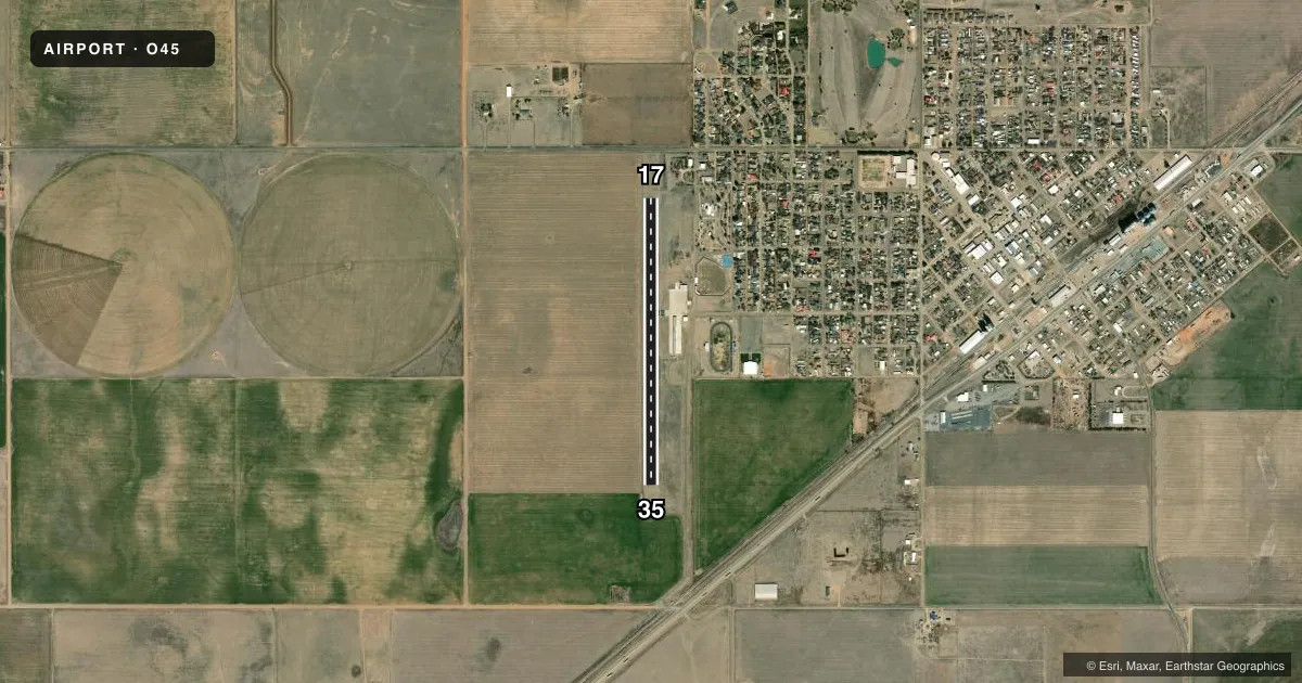
Runways & pattern
Full pagePattern entry · RWY 17
RIGHT TRAFFICRunway end performance
| End | TORA | TODA | ASDA | LDA | VGSI | Approach lights | Obstruction |
|---|---|---|---|---|---|---|---|
| 17 | — | — | — | — | PAPI 2-box left(3°) | — | — |
| 35 | — | — | — | — | PAPI 2-box left(3.5°) | — | 57', pline, 1338' from thr, 0' R of cntrln, slope 19 |
Declared distances in feet. TORA = takeoff run available, TODA = takeoff distance, ASDA = accelerate-stop, LDA = landing distance.
Airport sketch
Runways drawn to scale from FAA survey coordinates, rendered over satellite imagery. Not for navigation.
Approaches & charts
Services on the field
Fuel grades, oxygen, maintenance, ramp storage and lighting — as declared to the FAA by the airport operator.
Fuel & services
- Fuel
- 100LL
- Oxygen (bottled)
- Not available
- Oxygen (bulk)
- Not available
- Airframe repair
- Not available
- Power plant repair
- Not available
- Other services
- AGRI
Ramp & ground
- Transient storage
- Tie-down
- Landing fee
- No fee published
- Lighting schedule
- SEE RMK
- Beacon schedule
- SS-SR
- Beacon
- White / Green (civil land)(WG)
- Wind indicator
- Yes
- Segmented circle
- Yes
Fuel & FBOs
Cheapest 100LL and Jet A on the field and nearby. Always confirm with the FBO before taxi.
Airport notes
Surface conditions, obstructions, local procedures, lighting outages and other notes published with each FAA cycle.
General notes
- FOR CD CTC KANSAS CITY ARTCC AT 913-254-8508.
Lighting notes
- ACTVT MIRL RWY 17/35 - CTAF.
Fuel notes
- 100LLSELF SERVE FUEL AVBL H24.
Other notes
- PROVIDED ALL TRAFFIC PATTERNS ARE WEST OF PROPOSED ARPT; I.E. LEFT TFC RWY 35 AND RIGHT TFC RWY 17.
VFR map & nearby airports
VFR sectional. Tap any ICAO chip to open that airport.
Key facts · O45
Answer card- ICAO
- O45
- Name
- HOOKER MUNI
- Location
- HOOKER, OKLAHOMA
- Elevation
- 3,000.2 ft MSL
- Traffic pattern altitude
- 4,000.2 ft MSL (1,000 AGL)
- Control tower
- Non-towered (use CTAF)
- Total runways
- 1
- Longest runway
- 17/35 · 3,312 ft
- Published ILS approaches
- 0
- Published frequencies
- 1
- Magnetic variation
- 9°
- Current flight rules
- VFR
- Current wind
- 230° at 9 kt
- Favored runway now
- RWY 17
Hooker Muni sits in Hooker, Oklahoma. The field elevation is 3,000.2 ft MSL. It has one runway, 17/35, which is 3,312 ft long and asphalt. There is no control tower. CTAF is 122.9.
No ILS approaches are published here. The published pattern altitude is not listed, so use the standard 1,000 ft AGL pattern unless the current Chart Supplement says otherwise. The published remarks also say all traffic patterns are west of the airport. That means left traffic for runway 35 and right traffic for runway 17. Medium intensity runway lights on 17/35 are activated by the CTAF. Self-serve 100LL is available 24 hours a day.
Hooker Municipal Airport is the on-field FBO. It carries AVGAS 100LL and Jet A. Call ahead at (580) 652-2885 if you need current ramp or service details. For clearance delivery, contact Kansas City ARTCC at 913-254-8508. This is a high-elevation field, so expect density altitude to matter on warm days. The runway is not long by jet standards, so performance planning matters. Check the current FAA Chart Supplement for any updates before you go.