METAR & TAF H70
H70 does not publish a METAR.
Showing the nearest reporting station: KDUX (MOORE COUNTY) · 29.4 NM away. Conditions at H70 may differ.
METAR · KDUX
Observed 14:55Z
KDUX 271455Z AUTO 21014G17KT 10SM CLR 32/15 A3002 RMK AO2
- Wind
- 210° @ 14G17 kt
- Visibility
- 10 SM
- Temp / Dew
- 32°C / 15°C
- Altimeter
- 30.02 inHg
- Clouds
- CLR
- Density alt
- 6,465 ft
- Ceiling
- Unlimited
- Rules
- VFR
Airport info & contacts
Manager on record, flight service, ARTCC, attendance schedule and pattern altitude — published by the FAA and refreshed every 28 days.
Location
- From city
- 1 NM NE
- VFR sectional
- WICHITA
- ARTCC
- ZAB · ALBUQUERQUE
- NOTAM facility
- FTW (NOTAM-D)
Airport manager
- Name
- ROGER WELLS
- Phone
- 806-753-7866
- Address
- BOX 223, STRATFORD TX 79084
Flight service · Hours
- FSS FTW
- FORT WORTH1-800-WX-BRIEF
- Attendance
- Unattended
Frequencies
Tap any row to copy the frequency to your clipboard.
Runways & pattern
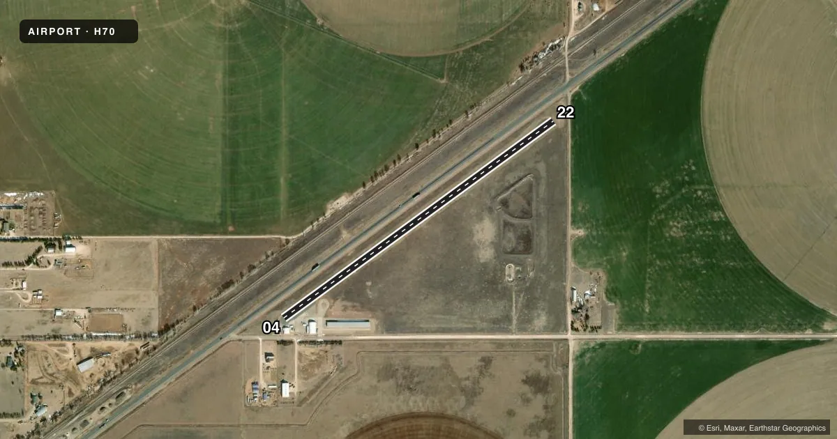
Full pagePattern entry · RWY 22
LEFT TRAFFICRunway end performance
| End | TORA | TODA | ASDA | LDA | VGSI | Approach lights | Obstruction |
|---|---|---|---|---|---|---|---|
| 04 | — | — | — | — | — | — | 15', road, 200' from thr, 50' R of cntrln, slope 0 |
| 22 | — | — | — | — | — | — | 15', road, 200' from thr, 35' R of cntrln, slope 0 |
Declared distances in feet. TORA = takeoff run available, TODA = takeoff distance, ASDA = accelerate-stop, LDA = landing distance.
Airport sketch
Runways drawn to scale from FAA survey coordinates, rendered over satellite imagery. Not for navigation.
Approaches & charts
Services on the field
Fuel grades, oxygen, maintenance, ramp storage and lighting — as declared to the FAA by the airport operator.
Fuel & services
- Fuel
- Not available
- Oxygen (bottled)
- Not available
- Oxygen (bulk)
- Not available
- Airframe repair
- Not available
- Power plant repair
- Not available
- Other services
- AGRI
Ramp & ground
- Transient storage
- Tie-down
- Hangar
- Landing fee
- No fee published
- Customs
- Not available
- Lighting schedule
- SEE RMK
- Wind indicator
- Lighted
- Segmented circle
- No
Fuel & FBOs
Cheapest 100LL and Jet A on the field and nearby. Always confirm with the FBO before taxi.
Airport notes
Surface conditions, obstructions, local procedures, lighting outages and other notes published with each FAA cycle.
General notes
- SEWAGE TREATMENT PLANT LCTD SOUTH OF RWY.
- (A70) EMERGENCY FUEL 100LL ONLY.
- FOR CD CTC ALBUQUERQUE ARTCC AT 505-856-4861.
Lighting notes
- ACTVT LIRL RWY 04/22 5X - CTAF.
Runway surface & condition
- 04/22LIRL LCTD 33 FT FM EDGE OF PAVEMENT. NONSTD SOLAR THR LGTS.
Approach & departure obstructions
- 04+20 FT HNGR AT THR 80 FT RIGHT CNTRLN.
- 2215 FT ROAD 166 FT FM THR, O BOTH SIDES.
- 04RWY NOT MKD.
- 22RWY NOT MKD.
- 04ALSO 35 FT. UNMKD, UNLIGHTED POLE, 325 FT DSTC, 120 FT L, APCH SLOPE 3:1.
Other notes
- THIS AIRPORT HAS BEEN SURVEYED BY THE NATIONAL GEODETIC SURVEY.
- 04/22RWY 04 END, BROKEN ASPH & LOOSE STONES.
VFR map & nearby airports
VFR sectional. Tap any ICAO chip to open that airport.
Key facts · H70
Answer card- ICAO
- H70
- Name
- STRATFORD FLD
- Location
- STRATFORD, TEXAS
- Elevation
- 3,668.2 ft MSL
- Traffic pattern altitude
- 4,668.2 ft MSL (1,000 AGL)
- Control tower
- Non-towered (use CTAF)
- Total runways
- 1
- Longest runway
- 04/22 · 3,023 ft
- Published ILS approaches
- 0
- Published frequencies
- 1
- Magnetic variation
- 9°
- Current flight rules
- VFR
- Current wind
- 210° at 14 kt
- Favored runway now
- RWY 22
Stratford Fld sits in Stratford, Texas. The field elevation is 3,668.2 ft MSL. It has one runway, 04/22, at 3,023 ft. There is no control tower. CTAF is 122.9. No ILS approaches are published here.
Pattern altitude is not published. Use the standard 1,000 ft AGL pattern unless the current Chart Supplement says otherwise. That puts the light piston pattern at about 4,668.2 ft MSL. This is a high-elevation field, so expect thinner air and longer takeoff rolls than you would at a lowland airport.
The published remarks matter here. Runway 04 has broken asphalt and loose stones at the end. Runway 04 is also not marked. Runway 22 is not marked either. There is a 35 ft unmarked, unlighted pole near the 04 approach path. A 20 ft hangar sits near the 04 threshold. A road is close to the 22 threshold on both sides. Low intensity runway lights are activated five times on CTAF. Nonstandard solar threshold lights are installed. Emergency fuel is 100LL only. No on-field FBOs are listed, so contact the airport operator directly or call the field on CTAF for current service options before arrival.
For clearance delivery, Albuquerque ARTCC is the published contact. Plan your arrival with the terrain, the elevation and the runway condition notes in mind.