METAR & TAF KDHT
Current METAR
Observed 11:53Z
KDHT 271153Z AUTO 20006KT 10SM CLR 22/12 A3003 RMK AO2 SLP095 T02220122 10289 20222 53003
- Wind
- 200° @ 6 kt
- Visibility
- 10 SM
- Temp / Dew
- 22°C / 12°C
- Altimeter
- 30.03 inHg
- Clouds
- CLR
- Density alt
- 5,653 ft
- Ceiling
- Unlimited
- Rules
- VFR
Airport info & contacts
Manager on record, flight service, ARTCC, attendance schedule and pattern altitude — published by the FAA and refreshed every 28 days.
Location
- From city
- 3 NM SW
- VFR sectional
- WICHITA
- ARTCC
- ZAB · ALBUQUERQUE
- NOTAM facility
- DHT (NOTAM-D)
Airport manager
- Name
- JOE LIVINGSTON
- Phone
- 806-244-5521
- Address
- PO BOX 2005, 205 ROCK ISLAND AVE., DALHART TX 79022
Flight service · Hours
- FSS FTW
- FORT WORTH1-800-WX-BRIEF
- Attendance
- 0800-1900
Frequencies
Tap any row to copy the frequency to your clipboard.
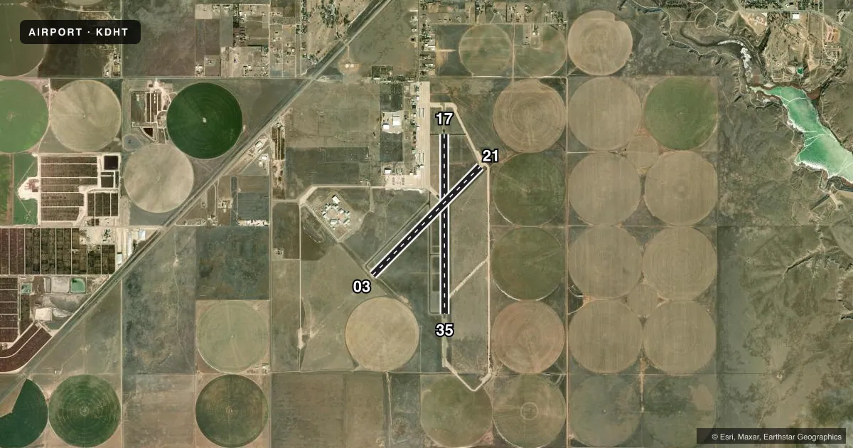
Runways & pattern
Full pagePattern entry · RWY 17
LEFT TRAFFIC| Runway | Heading (°M) | Length | Surface | Traffic |
|---|---|---|---|---|
| 17/35Favored | 171° / 351° | 6,400 ft | ASPH | Standard L |
| 03/21 | 36° / 216° | 5,440 ft | ASPH | Standard L |
Runway end performance
| End | TORA | TODA | ASDA | LDA | VGSI | Approach lights | Obstruction |
|---|---|---|---|---|---|---|---|
| 17 | — | — | — | — | PAPI 4-box left(3°) | — | — |
| 35 | — | — | — | — | PAPI 4-box left(3°) | — | — |
| 03 | — | — | — | — | — | — | 18', tree, 740' from thr, 125' R of cntrln, slope 30 |
| 21 | — | — | — | — | — | — | 7', ant, 271' from thr, 227' R of cntrln, slope 10 |
Declared distances in feet. TORA = takeoff run available, TODA = takeoff distance, ASDA = accelerate-stop, LDA = landing distance.
Airport sketch
Runways drawn to scale from FAA survey coordinates, rendered over satellite imagery. Not for navigation.
Approaches & charts
Services on the field
Fuel grades, oxygen, maintenance, ramp storage and lighting — as declared to the FAA by the airport operator.
Fuel & services
- Fuel
- 100LLA1
- Oxygen (bottled)
- Not available
- Oxygen (bulk)
- Not available
- Airframe repair
- Major
- Power plant repair
- Major
- Other services
- AGRI,AMB,INSTR
Ramp & ground
- Transient storage
- Tie-down
- Hangar
- Landing fee
- No fee published
- Customs
- Not available
- Lighting schedule
- SEE RMK
- Beacon schedule
- SS-SR
- Beacon
- White / Green (civil land)(WG)
- Wind indicator
- Lighted
- Segmented circle
- Yes
Fuel & FBOs
Cheapest 100LL and Jet A on the field and nearby. Always confirm with the FBO before taxi.
Airport notes
Surface conditions, obstructions, local procedures, lighting outages and other notes published with each FAA cycle.
General notes
- LARGE FLOCKS OF WATERFOWL INVOF LAKE RITA BLANCA 2 MI EAST SPRING & FALL.
- FOR CD IF UNA TO CTC ON FSS FREQ, CTC ALBUQUERQUE ARTCC AT 505-856-4561.
Lighting notes
- MIRL RWYS 03/21 & 17/35 PRESET LOW INTST; TO INCR INTST & ACTVT PAPI RWYS 17 & 35 - CTAF.
Fuel notes
- 100LLFOR JET A AFT HRS CALL 806-244-5521 DURG BUS HRS. 100 LL FULL & SELF SERVE.
Other notes
- MANAGERECONOMIC DEVELOPMENT DIR./ AMGR 806-244-5511.
- MANAGERARPT ATTENDANT/FBO.
VFR map & nearby airports
VFR sectional. Tap any ICAO chip to open that airport.
Key facts · KDHT
Answer card- ICAO
- KDHT
- Name
- DALHART MUNI
- Location
- DALHART, TEXAS
- Elevation
- 3,991.1 ft MSL
- Traffic pattern altitude
- 4,991.1 ft MSL (1,000 AGL)
- Control tower
- Non-towered (use CTAF)
- Total runways
- 2
- Longest runway
- 17/35 · 6,400 ft
- Published ILS approaches
- 0
- Published frequencies
- 2
- Magnetic variation
- 9°
- Current flight rules
- VFR
- Current wind
- 200° at 6 kt
- Favored runway now
- RWY 17
Dalhart Muni sits in Dalhart, Texas. The field elevation is 3,991.1 ft MSL. It has two asphalt runways. The longest is 17/35 at 6,400 ft. The other runway is 03/21 at 5,440 ft. There is no control tower. CTAF and UNICOM are both 122.95. No ILS approaches are published here.
Pattern altitude is not published in the facts, so use the standard 1,000 ft AGL for light piston operations unless the current Chart Supplement says otherwise. That puts the traffic pattern about 4,991 ft MSL based on the listed field elevation. The airport has a magnetic variation of 9°. Published remarks note that runway lights on 03/21 and 17/35 are preset to low intensity. To raise intensity and activate the PAPI on 17 and 35, use CTAF. Large flocks of waterfowl are reported near Lake Rita Blanca about 2 miles east during spring and fall, so keep a sharp scan on arrival and departure.
Two on-field FBOs are listed. Starlink Aviation carries 100LL and Jet A Prist. Flying W Aviation carries 100LL. For clearance delivery when flight service is not available, contact Albuquerque ARTCC. If you need current fuel, after-hours service, or ramp details, call the FBO directly before you go.