METAR & TAF KCAO
Current METAR
Observed 12:55Z
KCAO 271255Z AUTO 21004KT 10SM CLR 22/11 A3010 RMK AO2 SLP102 T02220106
- Wind
- 210° @ 4 kt
- Visibility
- 10 SM
- Temp / Dew
- 22°C / 11°C
- Altimeter
- 30.10 inHg
- Clouds
- CLR
- Density alt
- 6,779 ft
- Ceiling
- Unlimited
- Rules
- VFR
Airport info & contacts
Manager on record, flight service, ARTCC, attendance schedule and pattern altitude — published by the FAA and refreshed every 28 days.
Location
- From city
- 2 NM E
- VFR sectional
- WICHITA
- ARTCC
- ZAB · ALBUQUERQUE
- NOTAM facility
- CAO (NOTAM-D)
Airport manager
- Name
- ALYSSA MYERS
- Phone
- 575-374-9873
- Address
- 1 CHESTNUT ST, CLAYTON NM 88415
Flight service · Hours
- FSS ABQ
- ALBUQUERQUE1-800-WX-BRIEF
- Attendance
- 0800-1700
Frequencies
Tap any row to copy the frequency to your clipboard.
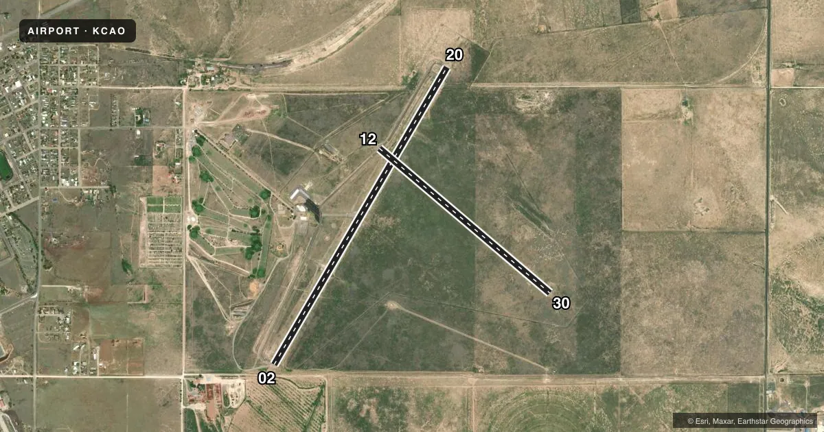
Runways & pattern
Full pagePattern entry · RWY 20
LEFT TRAFFIC| Runway | Heading (°M) | Length | Surface | Traffic |
|---|---|---|---|---|
| 02/20Favored | 21° / 201° | 6,307 ft | ASPH | Standard L |
| 12/30 | 121° / 301° | 4,105 ft | ASPH | Standard L |
Runway end performance
| End | TORA | TODA | ASDA | LDA | VGSI | Approach lights | Obstruction |
|---|---|---|---|---|---|---|---|
| 02 | — | — | — | — | PAPI 2-box left(3.05°) | — | — |
| 20 | — | — | — | — | PAPI 2-box left(3.05°) | — | — |
Declared distances in feet. TORA = takeoff run available, TODA = takeoff distance, ASDA = accelerate-stop, LDA = landing distance.
Airport sketch
Runways drawn to scale from FAA survey coordinates, rendered over satellite imagery. Not for navigation.
Approaches & charts
Services on the field
Fuel grades, oxygen, maintenance, ramp storage and lighting — as declared to the FAA by the airport operator.
Fuel & services
- Fuel
- 100LLA
Ramp & ground
- Transient storage
- Tie-down
- Landing fee
- No fee published
- Customs
- Not available
- Lighting schedule
- SEE RMK
- Beacon schedule
- SS-SR
- Beacon
- White / Green (civil land)(WG)
- Wind indicator
- Lighted
- Segmented circle
- Yes
Fuel & FBOs
Cheapest 100LL and Jet A on the field and nearby. Always confirm with the FBO before taxi.
Airport notes
Surface conditions, obstructions, local procedures, lighting outages and other notes published with each FAA cycle.
General notes
- REFLECTORS ALL TWYS.
- FOR CD CTC ALBUQUERQUE ARTCC AT 505-856-4861.
Lighting notes
- ACTVT PAPI RWY 02 & 20; MIRL RWY 02/20 & 12/30 - CTAF.
Fuel notes
- 100LL100 LL & JET A AVBL 24-7 SELF-SVC WITH MAJOR CREDIT CARD.
Approach & departure obstructions
- 028 FT ROAD 142 FT FM RWY END BOTH SIDES.
- 02APCH SLOPE 50:1+ TO DTHR.
Other notes
- OWNERFERON LUCERO.
- MANAGERALT PHONE: 575-429-9635 MGR CELL PHONE.
VFR map & nearby airports
VFR sectional. Tap any ICAO chip to open that airport.
Key facts · KCAO
Answer card- ICAO
- KCAO
- Name
- CLAYTON MUNI AIRPARK
- Location
- CLAYTON, NEW MEXICO
- Elevation
- 4,969.8 ft MSL
- Traffic pattern altitude
- 5,969.8 ft MSL (1,000 AGL)
- Control tower
- Non-towered (use CTAF)
- Total runways
- 2
- Longest runway
- 02/20 · 6,307 ft
- Published ILS approaches
- 0
- Published frequencies
- 2
- Magnetic variation
- 9°
- Current flight rules
- VFR
- Current wind
- 210° at 4 kt
- Favored runway now
- RWY 20
Clayton Muni Airpark sits in Clayton, New Mexico. Field elevation is 4,969.8 ft MSL. The airport has two asphalt runways. The longest is runway 02/20 at 6,307 ft. Runway 12/30 is 4,105 ft. There is no control tower. CTAF and UNICOM are both 122.8. No ILS approaches are published.
Pattern altitude is not published. Use the standard 1,000 ft AGL pattern for light piston aircraft unless the current Chart Supplement says otherwise. That puts the pattern about 5,970 ft MSL based on the field elevation. Runway lighting is pilot-controlled on 02/20 and 12/30. PAPI is available on 02 and 20. The field also has reflectors on all taxiways.
Clayton Municipal Airport is on the field. It carries 100LL and Jet A Prist. Fuel is self-serve 24 hours a day with a major credit card. For clearance delivery, contact Albuquerque ARTCC. First-time pilots should pay attention to the elevation and the high-plains setting. Density altitude can build quickly here. Runway 02 has an 8-foot road near the departure end on both sides. The approach slope to the displaced threshold on 02 is 50 to 1 or greater. Check the current Chart Supplement for any other local restrictions before you go.