METAR & TAF 17K
17K does not publish a METAR.
Showing the nearest reporting station: KEHA (ELKHART-MORTON COUNTY) · 33.2 NM away. Conditions at 17K may differ.
METAR · KEHA
Observed 13:15Z
KEHA 271315Z AUTO 21012G18KT 10SM CLR 28/12 A3000 RMK AO2 T02800122
- Wind
- 210° @ 12G18 kt
- Visibility
- 10 SM
- Temp / Dew
- 28°C / 12°C
- Altimeter
- 30.00 inHg
- Clouds
- CLR
- Density alt
- 6,637 ft
- Ceiling
- Unlimited
- Rules
- VFR
Airport info & contacts
Manager on record, flight service, ARTCC, attendance schedule and pattern altitude — published by the FAA and refreshed every 28 days.
Location
- From city
- 3 NM N
- VFR sectional
- WICHITA
- ARTCC
- ZAB · ALBUQUERQUE
- NOTAM facility
- MLC (NOTAM-D)
Airport manager
- Name
- HERMEN ESPARZA
- Phone
- 580-544-2271
- Address
- CITY HALL, P.O. BOX 129, BOISE CITY OK 73933
Flight service · Hours
- FSS MLC
- MC ALESTER1-800-WX-BRIEF
- Attendance
- Unattended
Frequencies
Tap any row to copy the frequency to your clipboard.
Runways & pattern
Full pagePattern entry · RWY 22
LEFT TRAFFICRunway end performance
| End | TORA | TODA | ASDA | LDA | VGSI | Approach lights | Obstruction |
|---|---|---|---|---|---|---|---|
| 04 | — | — | — | — | PAPI 4-box left(3°) | — | 22', trees, 234' from thr, 204' R of cntrln, slope 1 |
| 22 | — | — | — | — | PAPI 4-box left(3°) | — | 15', road, 450' from thr, slope 16 |
Declared distances in feet. TORA = takeoff run available, TODA = takeoff distance, ASDA = accelerate-stop, LDA = landing distance.
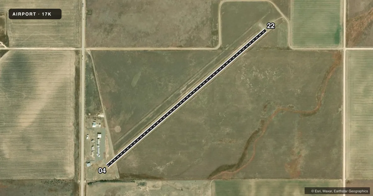
Airport sketch
Runways drawn to scale from FAA survey coordinates, rendered over satellite imagery. Not for navigation.
Approaches & charts
Services on the field
Fuel grades, oxygen, maintenance, ramp storage and lighting — as declared to the FAA by the airport operator.
Fuel & services
- Fuel
- 100LLAA+
- Oxygen (bottled)
- Not available
- Oxygen (bulk)
- Not available
- Airframe repair
- Not available
- Power plant repair
- Not available
- Other services
- AGRI
Ramp & ground
- Transient storage
- Tie-down
- Landing fee
- No fee published
- Customs
- Not available
- Lighting schedule
- SEE RMK
- Beacon schedule
- SS-SR
- Beacon
- White / Green (civil land)(WG)
- Wind indicator
- Lighted
- Segmented circle
- Yes
Fuel & FBOs
Cheapest 100LL and Jet A on the field and nearby. Always confirm with the FBO before taxi.
Airport notes
Surface conditions, obstructions, local procedures, lighting outages and other notes published with each FAA cycle.
General notes
- FOR CD CTC ALBUQUERQUE ARTCC AT 505-856-4861.
Lighting notes
- ACTVT PAPI RWY 04 & 22 - CTAF. MIRL RWY 04/22 SS-SR; PRESET LOW INTST; INCR INTST - CTAF.
Fuel notes
- 100LLFUEL AVBL 24HRS W/ CC.
Approach & departure obstructions
- 04PAPI UNUSBL BYD 5 DEGS LEFT OF CNTRLN.
- 0420 FT TREELINE CROSSES RWY 04 APCH.
VFR map & nearby airports
VFR sectional. Tap any ICAO chip to open that airport.
Key facts · 17K
Answer card- ICAO
- 17K
- Name
- BOISE CITY
- Location
- BOISE CITY, OKLAHOMA
- Elevation
- 4,174.3 ft MSL
- Traffic pattern altitude
- 5,174.3 ft MSL (1,000 AGL)
- Control tower
- Non-towered (use CTAF)
- Total runways
- 1
- Longest runway
- 04/22 · 4,211 ft
- Published ILS approaches
- 0
- Published frequencies
- 1
- Magnetic variation
- 9°
- Current flight rules
- VFR
- Current wind
- 210° at 12 kt
- Favored runway now
- RWY 22
Boise City Airport sits in Boise City, Oklahoma. Field elevation is 4,174.3 ft MSL. The airport has one runway. Runway 04/22 is 4,211 ft long with an asphalt surface. There is no control tower. CTAF is 122.9.
No ILS approaches are published here. The pattern altitude is not published, so use the standard 1,000 ft AGL pattern unless the current Chart Supplement says otherwise. That puts the light aircraft pattern at 5,174.3 ft MSL based on field elevation. For clearance delivery, contact Albuquerque ARTCC at 505-856-4861.
Fuel is available 24 hours with a credit card. The published remarks also note that the PAPI on 04 and 22 is CTAF-activated. Medium intensity runway lights run from sunset to sunrise at low preset intensity. You can raise the intensity by keying the CTAF. Be aware of the 20-foot treeline crossing the approach to runway 04. The PAPI on runway 04 is unusable beyond 5 degrees left of centerline. This is a high-elevation field, so expect performance to matter on warm days. Check density altitude before you go.