METAR & TAF 8V7
Current METAR
Observed 06:55Z
K8V7 270655Z AUTO 20018KT 10SM CLR 29/10 A3001 RMK AO2
- Wind
- 200° @ 18 kt
- Visibility
- 10 SM
- Temp / Dew
- 29°C / 10°C
- Altimeter
- 30.01 inHg
- Clouds
- CLR
- Density alt
- 7,012 ft
- Ceiling
- Unlimited
- Rules
- VFR
Airport info & contacts
Manager on record, flight service, ARTCC, attendance schedule and pattern altitude — published by the FAA and refreshed every 28 days.
Location
- From city
- 4 NM N
- VFR sectional
- WICHITA
- ARTCC
- ZAB · ALBUQUERQUE
- NOTAM facility
- DEN (NOTAM-D)
Airport manager
- Name
- BRETT FIGGINS
- Phone
- 719-529-9791
- Address
- PO BOX 4, SPRINGFIELD CO 81073
Flight service · Hours
- FSS DEN
- DENVER1-800-WX-BRIEF
- Attendance
- Unattended
Frequencies
Tap any row to copy the frequency to your clipboard.
Runways & pattern
Full pagePattern entry · RWY 17
LEFT TRAFFICRunway end performance
| End | TORA | TODA | ASDA | LDA | VGSI | Approach lights | Obstruction |
|---|---|---|---|---|---|---|---|
| 17 | — | — | — | — | PAPI 2-box left(3°) | — | — |
| 35 | — | — | — | — | PAPI 2-box left(3°) | — | — |
Declared distances in feet. TORA = takeoff run available, TODA = takeoff distance, ASDA = accelerate-stop, LDA = landing distance.
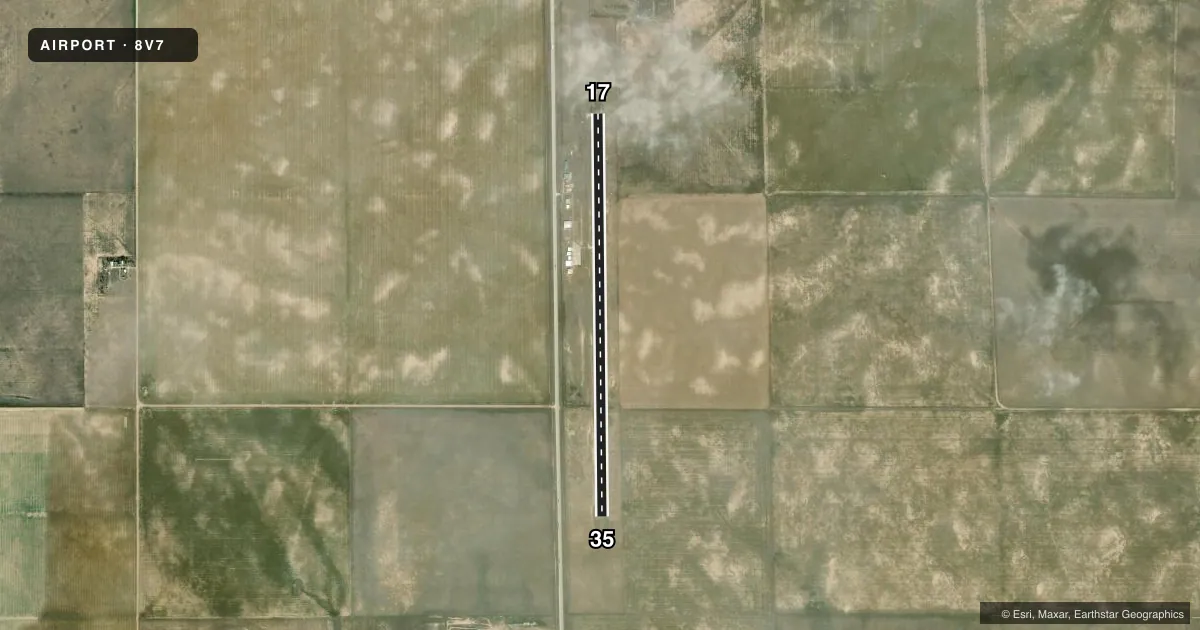
Airport sketch
Runways drawn to scale from FAA survey coordinates, rendered over satellite imagery. Not for navigation.
Approaches & charts
Services on the field
Fuel grades, oxygen, maintenance, ramp storage and lighting — as declared to the FAA by the airport operator.
Fuel & services
- Fuel
- 100LL
- Other services
- AGRI
Ramp & ground
- Transient storage
- Tie-down
- Landing fee
- No fee published
- Customs
- Not available
- Lighting schedule
- SEE RMK
- Beacon schedule
- SS-SR
- Beacon
- White / Green (civil land)(WG)
- Wind indicator
- Lighted
- Segmented circle
- Yes
Fuel & FBOs
Cheapest 100LL and Jet A on the field and nearby. Always confirm with the FBO before taxi.
Airport notes
Surface conditions, obstructions, local procedures, lighting outages and other notes published with each FAA cycle.
General notes
- TWY MKD WITH BLUE & YELLOW REFLECTORS.
- ALERT; USAF TRNG INVOF COLORADO SPRINGS & PUEBLO COLORADO.
- FOR CD CTC ALBUQUERQUE ARTCC AT 505-856-4861.
Lighting notes
- ACTVT PAPI RWY 17 & 35; MIRL RWY 17/35 - CTAF.
VFR map & nearby airports
VFR sectional. Tap any ICAO chip to open that airport.
Key facts · 8V7
Answer card- ICAO
- 8V7
- Name
- SPRINGFIELD MUNI
- Location
- SPRINGFIELD, COLORADO
- Elevation
- 4,390.2 ft MSL
- Traffic pattern altitude
- 5,390.2 ft MSL (1,000 AGL)
- Control tower
- Non-towered (use CTAF)
- Total runways
- 1
- Longest runway
- 17/35 · 5,000 ft
- Published ILS approaches
- 0
- Published frequencies
- 1
- Magnetic variation
- 8°
- Current flight rules
- VFR
- Current wind
- 200° at 18 kt
- Favored runway now
- RWY 17
Springfield Muni is in Springfield, Colorado. The field elevation is 4,390.2 ft MSL. It has one runway, 17/35, which is 5,000 ft long with a concrete surface. There is no control tower. CTAF is 122.9.
No ILS approaches are published here. Pattern altitude is not published in the facts, so use the standard 1,000 ft AGL for light piston operations unless the current FAA Chart Supplement says otherwise. The runway lights on 17 and 35 are medium intensity. They are controlled by CTAF. PAPI is active on both ends.
There are no on-field FBOs listed in the facts. Contact the airport operator directly before arrival, or call the field on CTAF for current FBO availability. The published remarks also note military training activity in the Colorado Springs and Pueblo area. Expect to stay alert for that traffic when you are operating in the region. Clearance delivery is handled through Albuquerque ARTCC at 505-856-4861. Taxiways are marked with blue and yellow reflectors. At this elevation, performance planning matters. Check density altitude before departure, especially on warm days.