METAR & TAF KLAA
Current METAR
Observed 06:53Z
KLAA 270653Z AUTO 20017G23KT 10SM CLR 32/12 A2992 RMK AO2 PK WND 19029/0633 SLP058 T03170122 404390178
- Wind
- 200° @ 17G23 kt
- Visibility
- 10 SM
- Temp / Dew
- 32°C / 12°C
- Altimeter
- 29.92 inHg
- Clouds
- CLR
- Density alt
- 6,635 ft
- Ceiling
- Unlimited
- Rules
- VFR
Airport info & contacts
Manager on record, flight service, ARTCC, attendance schedule and pattern altitude — published by the FAA and refreshed every 28 days.
Location
- From city
- 3 NM SW
- VFR sectional
- WICHITA
- ARTCC
- ZDV · DENVER
- NOTAM facility
- LAA (NOTAM-D)
Airport manager
- Name
- PATRICK MASON
- Phone
- 719-336-2002
- Address
- 102 E PARMENTER, LAMAR CO 81052
Flight service · Hours
- FSS DEN
- DENVER1-800-WX-BRIEF
- Attendance
- 0800-1700
Frequencies
Tap any row to copy the frequency to your clipboard.
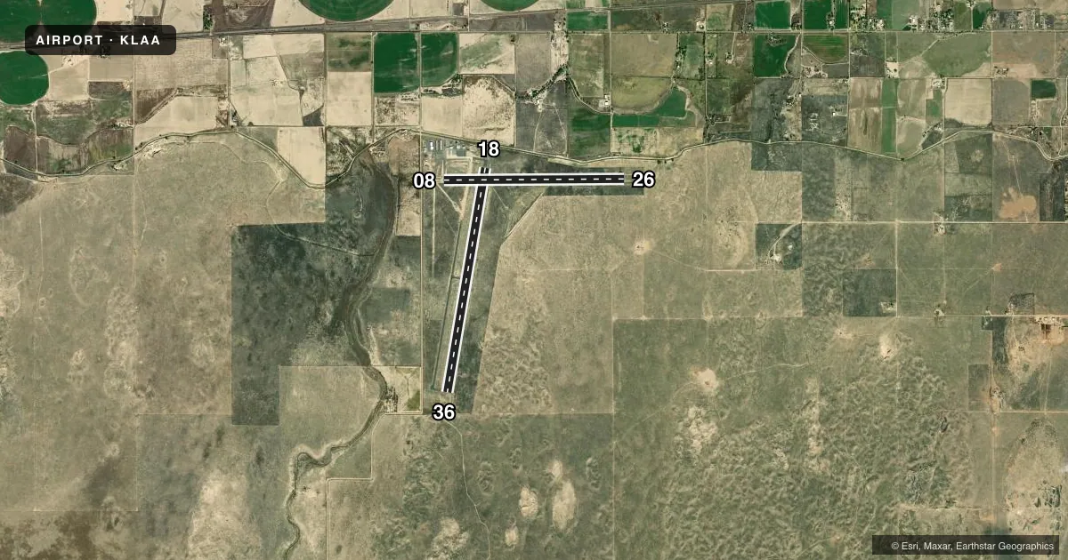
Runways & pattern
Full pagePattern entry · RWY 18
LEFT TRAFFIC| Runway | Heading (°M) | Length | Surface | Traffic |
|---|---|---|---|---|
| 18/36Favored | 183° / 3° | 6,304 ft | CONC | Standard L |
| 08/26 | 83° / 263° | 5,001 ft | ASPH | Standard L |
Runway end performance
| End | TORA | TODA | ASDA | LDA | VGSI | Approach lights | Obstruction |
|---|---|---|---|---|---|---|---|
| 18 | — | — | — | — | VASI 4-box left(3°) | — | 30', road, 672' from thr, 0' R of cntrln, slope 15 |
| 36 | — | — | — | — | PAPI 4-box left(3°) | — | 28', hill, 946' from thr, 210' R of cntrln, slope 26 |
| 08 | — | — | — | — | PAPI 2-box left(3°) | — | 25', road, 599' from thr, 0' R of cntrln, slope 15 |
| 26 | — | — | — | — | PAPI 2-box left(3°) | — | — |
Declared distances in feet. TORA = takeoff run available, TODA = takeoff distance, ASDA = accelerate-stop, LDA = landing distance.
Airport sketch
Runways drawn to scale from FAA survey coordinates, rendered over satellite imagery. Not for navigation.
Approaches & charts
Services on the field
Fuel grades, oxygen, maintenance, ramp storage and lighting — as declared to the FAA by the airport operator.
Fuel & services
- Fuel
- 100LLA
- Oxygen (bottled)
- Low pressure
- Oxygen (bulk)
- Low pressure
- Airframe repair
- Major
- Power plant repair
- Major
- Other services
- AGRI,CHTR,INSTR,RNTL,SURV
Ramp & ground
- Transient storage
- Tie-down
- Hangar
- Landing fee
- No fee published
- Customs
- Not available
- Lighting schedule
- SEE RMK
- Beacon schedule
- SS-SR
- Beacon
- White / Green (civil land)(WG)
- Wind indicator
- Lighted
- Segmented circle
- Yes
Fuel & FBOs
Cheapest 100LL and Jet A on the field and nearby. Always confirm with the FBO before taxi.
Airport notes
Surface conditions, obstructions, local procedures, lighting outages and other notes published with each FAA cycle.
General notes
- TOWER 500 FT AGL 4.5 MI SE UNLIGHTED.
- BE ALERT; INTENSIVE USAF STUDENT TRAINING IN VICINITY OF COLORADO SPRINGS & PUEBLO COLORADO.
- FOR CD CTC DENVER ARTCC AT 303-651-4257.
Lighting notes
- ACTVT & INCR INTST REIL RWY 08 & 26, RWY 18 & 36; PAPI RWY 08 & 26, RWY 36; VASI RWY 18; MIRL RWY 08/26, 18/36; TWY LGTS - CTAF. ALL LGTS PRESET MED INTST.
Fuel notes
- 100LL100LL AVBL H24 SELF SVC.
Other notes
- 1FOR SVC AFT HRS PHONE 719-336-7701.
VFR map & nearby airports
VFR sectional. Tap any ICAO chip to open that airport.
Key facts · KLAA
Answer card- ICAO
- KLAA
- Name
- SOUTHEAST COLORADO RGNL
- Location
- LAMAR, COLORADO
- Elevation
- 3,705.3 ft MSL
- Traffic pattern altitude
- 4,705.3 ft MSL (1,000 AGL)
- Control tower
- Non-towered (use CTAF)
- Total runways
- 2
- Longest runway
- 18/36 · 6,304 ft
- Published ILS approaches
- 0
- Published frequencies
- 2
- Magnetic variation
- 7°
- Current flight rules
- VFR
- Current wind
- 200° at 17 kt
- Favored runway now
- RWY 18
Southeast Colorado Rgnl is in Lamar, Colorado. The field elevation is 3,705.3 ft MSL. It has two runways. The longest is 6,304 ft on runway 18/36. This is a non-towered field. CTAF and UNICOM are both 122.8. No ILS approaches are published here.
Pattern altitude is not published. Use the standard 1,000 ft AGL for light piston traffic unless the current Chart Supplement says otherwise. The airport sits in southeast Colorado, so density altitude can be a real factor on warm days. Plan performance with that in mind.
On the field, Southeast Colorado Regional Airport carries 100LL and Jet A Prist. 100LL is available 24 hours a day self service. For service after hours, call 719-336-7701. Published remarks also note that taxiway lights are controlled by CTAF. All lights are preset to medium intensity. Runway lighting includes MIRLs on both runways. REILs are on 08, 26, 18 and 36. PAPI is on 08, 26 and 36. VASI is on 18.
For a first-time arrival, watch the traffic flow closely. The field is non-towered. Clearance delivery is handled through Denver ARTCC at 303-651-4257. The published remarks also call out intensive U.S. Air Force student training near Colorado Springs and Pueblo. Keep your scan up on the way in and out.