METAR & TAF KPPA
Current METAR
Observed 18:50Z
KPPA 271850Z AUTO 14006G14KT 10SM CLR 41/12 A2997 RMK AO2 T04050115
- Wind
- 140° @ 6G14 kt
- Visibility
- 10 SM
- Temp / Dew
- 41°C / 12°C
- Altimeter
- 29.97 inHg
- Clouds
- CLR
- Density alt
- 7,082 ft
- Ceiling
- Unlimited
- Rules
- VFR
Airport info & contacts
Manager on record, flight service, ARTCC, attendance schedule and pattern altitude — published by the FAA and refreshed every 28 days.
Location
- From city
- 5 NM NW
- VFR sectional
- DALLAS-FT WORTH
- ARTCC
- ZAB · ALBUQUERQUE
- NOTAM facility
- PPA (NOTAM-D)
Airport manager
- Name
- CHRIS PORTER
- Phone
- 806-669-8007
- Address
- 205 N. RUSSELL, PAMPA TX 79065
Flight service · Hours
- FSS FTW
- FORT WORTH1-800-WX-BRIEF
- Attendance
- 0800-1700
Frequencies
Tap any row to copy the frequency to your clipboard.
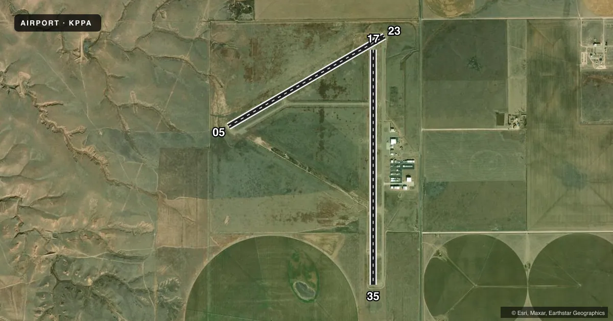
Runways & pattern
Full pagePattern entry · RWY 17
LEFT TRAFFIC| Runway | Heading (°M) | Length | Surface | Traffic |
|---|---|---|---|---|
| 17/35Favored | 174° / 354° | 5,862 ft | ASPH | Standard L |
| 05/23 | 54° / 234° | 4,500 ft | ASPH | Standard L |
Runway end performance
| End | TORA | TODA | ASDA | LDA | VGSI | Approach lights | Obstruction |
|---|---|---|---|---|---|---|---|
| 17 | — | — | — | — | PAPI 2-box left(3°) | — | 15', road, 730' from thr, 0' R of cntrln, slope 35 |
| 35 | — | — | — | — | PAPI 2-box left(3°) | — | — |
| 23 | — | — | — | — | — | — | 25', pline, 900' from thr, 25' R of cntrln, slope 28 |
Declared distances in feet. TORA = takeoff run available, TODA = takeoff distance, ASDA = accelerate-stop, LDA = landing distance.
Airport sketch
Runways drawn to scale from FAA survey coordinates, rendered over satellite imagery. Not for navigation.
Approaches & charts
Services on the field
Fuel grades, oxygen, maintenance, ramp storage and lighting — as declared to the FAA by the airport operator.
Fuel & services
- Fuel
- 100LLA1+
- Oxygen (bottled)
- Not available
- Oxygen (bulk)
- Not available
- Airframe repair
- Major
- Power plant repair
- Major
- Other services
- AGRI,INSTR
Ramp & ground
- Transient storage
- Tie-down
- Hangar
- Landing fee
- No fee published
- Customs
- Not available
- Lighting schedule
- SEE RMK
- Beacon schedule
- SS-SR
- Beacon
- White / Green (civil land)(WG)
- Wind indicator
- Lighted
- Segmented circle
- Yes
Fuel & FBOs
Cheapest 100LL and Jet A on the field and nearby. Always confirm with the FBO before taxi.
Airport notes
Surface conditions, obstructions, local procedures, lighting outages and other notes published with each FAA cycle.
General notes
- ANTELOPE ON & INVOF RWY.
- NO LINE OF SIGHT BTN BOTH RWY ENDS.
- FOR CD CTC ALBUQUERQUE ARTCC AT 505-856-4861.
Lighting notes
- DUSK-DAWN. MIRL RWYS 05/23 & 17/35 PRESET LOW INTST; TO INCR INTST ACTVT - CTAF.
Fuel notes
- 100LLFOR FUEL AFT HRS CALL 806-395-1117.
Approach & departure obstructions
- 17TAIL HGT OF AIRPLANE ON RWY 05/23, 173 FT FM CNTRLN TO THR.
Other notes
- THIS AIRPORT HAS BEEN SURVEYED BY THE NATIONAL GEODETIC SURVEY.
- MANAGERRON UNRUH 806-665-1881. AFTR HRS DARRELL DOWNS 806-395-1117.
- OWNERCO. CLERK.
VFR map & nearby airports
VFR sectional. Tap any ICAO chip to open that airport.
Key facts · KPPA
Answer card- ICAO
- KPPA
- Name
- PERRY LEFORS FLD
- Location
- PAMPA, TEXAS
- Elevation
- 3,245.2 ft MSL
- Traffic pattern altitude
- 4,245.2 ft MSL (1,000 AGL)
- Control tower
- Non-towered (use CTAF)
- Total runways
- 2
- Longest runway
- 17/35 · 5,862 ft
- Published ILS approaches
- 0
- Published frequencies
- 2
- Magnetic variation
- 6°
- Current flight rules
- VFR
- Current wind
- 140° at 6 kt
- Favored runway now
- RWY 17
Perry Lefors Fld (KPPA) sits in Pampa, Texas at 3,245.2 ft MSL. It has two asphalt runways. The longest is 17/35 at 5,862 ft. The other runway is 05/23 at 4,500 ft. There is no control tower. CTAF and UNICOM are both 122.7. No ILS approaches are published here.
Pattern altitude is not published. Use the standard 1,000 ft AGL for light piston traffic unless local procedures or ATC say otherwise. Pampa Aircraft is on the field. It carries 100LL and Jet A Prist. For fuel after hours, call the number in the Chart Supplement or the FBO directly. The airport remarks also note that runway lighting is preset to low intensity from dusk to dawn. You can increase intensity by keying the CTAF. There is no line of sight between both runway ends. Antelope are reported on and near the runway, so keep a sharp scan on taxi, takeoff and landing. Clearance delivery is handled through Albuquerque ARTCC. This is a high-elevation field in open country. Expect performance to reflect the density altitude. Especially on warm Texas days.