METAR & TAF KBGD
Current METAR
Observed 12:51Z
KBGD 271251Z AUTO 23007KT 10SM CLR 26/14 A3000 RMK AO2 SLP103 T02610144
- Wind
- 230° @ 7 kt
- Visibility
- 10 SM
- Temp / Dew
- 26°C / 14°C
- Altimeter
- 30.00 inHg
- Clouds
- CLR
- Density alt
- 5,009 ft
- Ceiling
- Unlimited
- Rules
- VFR
Airport info & contacts
Manager on record, flight service, ARTCC, attendance schedule and pattern altitude — published by the FAA and refreshed every 28 days.
Location
- From city
- 2 NM N
- VFR sectional
- DALLAS-FT WORTH
- ARTCC
- ZAB · ALBUQUERQUE
- NOTAM facility
- BGD (NOTAM-D)
Airport manager
- Name
- BATHAZAR MEDRANO
- Phone
- 806-273-0137
- Address
- BOX 3470, BORGER TX 79008
Flight service · Hours
- FSS FTW
- FORT WORTH1-800-WX-BRIEF
- Attendance
- 0800-1800
Frequencies
Tap any row to copy the frequency to your clipboard.
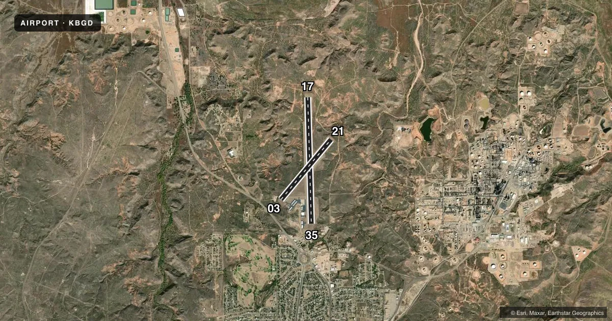
Runways & pattern
Full pagePattern entry · RWY 21
LEFT TRAFFIC| Runway | Heading (°M) | Length | Surface | Traffic |
|---|---|---|---|---|
| 17/35 | 171° / 351° | 6,299 ft | ASPH | Standard L |
| 03/21Favored | 33° / 213° | 3,897 ft | ASPH | Standard L |
Runway end performance
| End | TORA | TODA | ASDA | LDA | VGSI | Approach lights | Obstruction |
|---|---|---|---|---|---|---|---|
| 17 | — | — | — | — | PAPI 4-box left(3°) | — | 18', pole, 230' from thr, 408' R of cntrln, slope 1 |
| 35 | — | — | — | — | PAPI 4-box right(3°) | — | 52', trees, 1420' from thr, 42' R of cntrln, slope 23 |
Declared distances in feet. TORA = takeoff run available, TODA = takeoff distance, ASDA = accelerate-stop, LDA = landing distance.
Airport sketch
Runways drawn to scale from FAA survey coordinates, rendered over satellite imagery. Not for navigation.
Approaches & charts
Services on the field
Fuel grades, oxygen, maintenance, ramp storage and lighting — as declared to the FAA by the airport operator.
Fuel & services
- Fuel
- 100LLA+
- Other services
- INSTR,RNTL
Ramp & ground
- Transient storage
- Tie-down
- Hangar
- Landing fee
- No fee published
- Customs
- Not available
- Lighting schedule
- SEE RMK
- Beacon schedule
- SS-SR
- Beacon
- White / Green (civil land)(WG)
- Wind indicator
- Lighted
- Segmented circle
- Yes
Fuel & FBOs
Cheapest 100LL and Jet A on the field and nearby. Always confirm with the FBO before taxi.
Airport notes
Surface conditions, obstructions, local procedures, lighting outages and other notes published with each FAA cycle.
General notes
- FOR CD CTC ALBUQUERQUE ARTCC AT 505-856-4861.
- RWY 21, 100 FT DROP-OFF, 95 FT DSTC.
- RWY 3, 40 FT DROP-OFF, 150 FT DSTC.
Lighting notes
- ACTVT PAPI RWYS 17 & 35; MIRL RWYS 03/21 & 17/35 - CTAF.
Approach & departure obstructions
- 0315 FT TREE, 130 FT DSTC, 95 FT L.
VFR map & nearby airports
VFR sectional. Tap any ICAO chip to open that airport.
Key facts · KBGD
Answer card- ICAO
- KBGD
- Name
- HUTCHINSON COUNTY
- Location
- BORGER, TEXAS
- Elevation
- 3,055.2 ft MSL
- Traffic pattern altitude
- 4,055.2 ft MSL (1,000 AGL)
- Control tower
- Non-towered (use CTAF)
- Total runways
- 2
- Longest runway
- 17/35 · 6,299 ft
- Published ILS approaches
- 0
- Published frequencies
- 6
- Magnetic variation
- 7°
- Current flight rules
- VFR
- Current wind
- 230° at 7 kt
- Favored runway now
- RWY 21
Hutchinson County Airport sits in Borger, Texas. The field elevation is 3,055.2 ft MSL. It has two asphalt runways. The longest is runway 17/35 at 6,299 ft. Runway 03/21 is 3,897 ft. There is no control tower. No ILS approaches are published.
For pattern work, the published pattern altitude is not listed. Use the standard 1,000 ft AGL for light piston operations unless the current FAA Chart Supplement says otherwise. That puts you around 4,055 ft MSL at this field. The airport is in the Amarillo approach area. Clearance delivery is handled through Albuquerque ARTCC per the published remarks.
Hutchinson County Airport has one on-field FBO. Hutchinson County Airport carries 100LL and Jet A Prist. Call the FBO directly at (806) 273-0137 for current service details before you go. Published remarks also note a tree near runway 03 and a drop-off near runway 21. Runway 03 has a 40 ft drop-off nearby. Runway 21 has a 100 ft drop-off nearby. PAPI is available on runways 17 and 35. Medium intensity runway lights are on both runways and are controlled by CTAF. For a first-time arrival, the big items are the high field elevation, the non-towered flow and the runway edge terrain near the 03 and 21 ends.