METAR & TAF 93F
93F does not publish a METAR.
Showing the nearest reporting station: KELK (ELK CITY RGNL BUSINESS) · 18.3 NM away. Conditions at 93F may differ.
METAR · KELK
Observed 17:15Z
KELK 271715Z AUTO 20011KT 10SM CLR 36/16 A2992 RMK AO2 T03630159 $
- Wind
- 200° @ 11 kt
- Visibility
- 10 SM
- Temp / Dew
- 36°C / 16°C
- Altimeter
- 29.92 inHg
- Clouds
- CLR
- Density alt
- 5,116 ft
- Ceiling
- Unlimited
- Rules
- VFR
Airport info & contacts
Manager on record, flight service, ARTCC, attendance schedule and pattern altitude — published by the FAA and refreshed every 28 days.
Location
- From city
- 2 NM W
- VFR sectional
- DALLAS-FT WORTH
- ARTCC
- ZFW · FORT WORTH
- NOTAM facility
- MLC (NOTAM-D)
Airport manager
- Name
- CHRIS MOORE
- Phone
- 580-878-1122
- Address
- 9625 N 1910 RD, CHEYENNE OK 73628
Flight service · Hours
- FSS MLC
- MC ALESTER1-800-WX-BRIEF
- Attendance
- Unattended
Frequencies
Tap any row to copy the frequency to your clipboard.
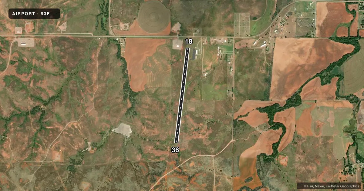
Runways & pattern
Full pagePattern entry · RWY 18
LEFT TRAFFICRunway end performance
| End | TORA | TODA | ASDA | LDA | VGSI | Approach lights | Obstruction |
|---|---|---|---|---|---|---|---|
| 18 | — | — | — | — | PAPI 2-box left(3°) | — | — |
| 36 | — | — | — | — | PAPI 2-box left(3°) | — | — |
Declared distances in feet. TORA = takeoff run available, TODA = takeoff distance, ASDA = accelerate-stop, LDA = landing distance.
Airport sketch
Runways drawn to scale from FAA survey coordinates, rendered over satellite imagery. Not for navigation.
Approaches & charts
Services on the field
Fuel grades, oxygen, maintenance, ramp storage and lighting — as declared to the FAA by the airport operator.
Fuel & services
- Fuel
- 100LL
- Oxygen (bottled)
- Not available
- Oxygen (bulk)
- Not available
- Airframe repair
- Not available
- Power plant repair
- Not available
Ramp & ground
- Transient storage
- Tie-down
- Hangar
- Landing fee
- No fee published
- Customs
- Not available
- Lighting schedule
- SEE RMK
- Beacon schedule
- SS-SR
- Beacon
- White / Green (civil land)(WG)
- Wind indicator
- Lighted
- Segmented circle
- Yes
Fuel & FBOs
Cheapest 100LL and Jet A on the field and nearby. Always confirm with the FBO before taxi.
Airport notes
Surface conditions, obstructions, local procedures, lighting outages and other notes published with each FAA cycle.
General notes
- FOR CD CTC FORT WORTH ARTCC AT 817-858-7584.
Lighting notes
- MIRL RWY 18/36 PRESET LOW INTST SS-SR. ACTVT & INCR INTST - CTAF.
Fuel notes
- 100LLAVBL 24 HRS.
Other notes
- MANAGERBOARD CHAIRMAN
VFR map & nearby airports
VFR sectional. Tap any ICAO chip to open that airport.
Key facts · 93F
Answer card- ICAO
- 93F
- Name
- MIGNON LAIRD MUNI
- Location
- CHEYENNE, OKLAHOMA
- Elevation
- 2,093.3 ft MSL
- Traffic pattern altitude
- 3,093.3 ft MSL (1,000 AGL)
- Control tower
- Non-towered (use CTAF)
- Total runways
- 1
- Longest runway
- 18/36 · 4,022 ft
- Published ILS approaches
- 0
- Published frequencies
- 1
- Magnetic variation
- 8°
- Current flight rules
- VFR
- Current wind
- 200° at 11 kt
- Favored runway now
- RWY 18
Mignon Laird Muni sits in Cheyenne, Oklahoma. The field elevation is 2,093.3 ft MSL. It has one runway, 18/36, which is 4,022 ft long and asphalt. There is no control tower, so expect self-announce traffic on CTAF 122.9. No ILS approaches are published here.
The published pattern altitude is not listed, so use the standard 1,000 ft AGL for light piston operations unless the current Chart Supplement says otherwise. Runway 18/36 has medium intensity lights. They are preset to low intensity from sunset to sunrise. You can increase the lights from the CTAF.
100LL is available 24 hours. No on-field FBOs are listed, so call the airport operator directly before arrival if you need ramp or fuel details. For clearance delivery, contact Fort Worth ARTCC at 817-858-7584. The field is in a non-towered environment, so keep your radio calls tight and watch for local traffic. At this elevation, density altitude can matter on warm days. Plan your takeoff and landing performance with that in mind.