METAR & TAF F36
F36 does not publish a METAR.
Showing the nearest reporting station: KCSM (INFINITY ONE OKLAHOMA SPACEPORT) · 11.7 NM away. Conditions at F36 may differ.
METAR · KCSM
Observed 20:53Z
KCSM 232053Z 13009G21KT 10SM FEW065 38/21 A2999 RMK AO2 SLP123 T03780211 56018
- Wind
- 130° @ 9G21 kt
- Visibility
- 10 SM
- Temp / Dew
- 38°C / 21°C
- Altimeter
- 29.99 inHg
- Clouds
- FEW
- Density alt
- 4,644 ft
- Ceiling
- Unlimited
- Rules
- VFR
Airport info & contacts
Manager on record, flight service, ARTCC, attendance schedule and pattern altitude — published by the FAA and refreshed every 28 days.
Location
- From city
- 1 NM E
- VFR sectional
- DALLAS-FT WORTH
- ARTCC
- ZFW · FORT WORTH
- NOTAM facility
- MLC (NOTAM-D)
Airport manager
- Name
- CHARLIE BROWN
- Phone
- 580-660-0417
- Address
- 525 GREGORY PARK LANE, CORDELL OK 73632
Flight service · Hours
- FSS MLC
- MC ALESTER1-800-WX-BRIEF
- Attendance
- INTMT
Frequencies
Tap any row to copy the frequency to your clipboard.
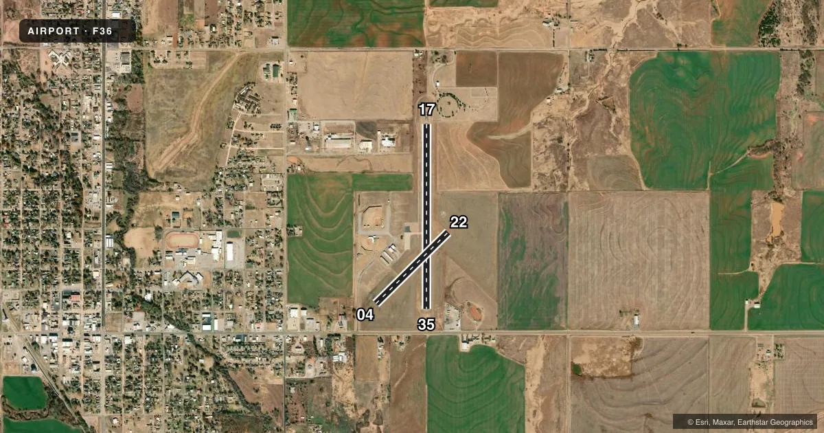
Runways & pattern
Full pagePattern entry · RWY 17
LEFT TRAFFIC| Runway | Heading (°M) | Length | Surface | Traffic |
|---|---|---|---|---|
| 17/35Favored | 172° / 352° | 3,430 ft | ASPH | Standard L |
| 04/22 | 37° / 217° | 1,886 ft | TURF | Standard L |
Runway end performance
| End | TORA | TODA | ASDA | LDA | VGSI | Approach lights | Obstruction |
|---|---|---|---|---|---|---|---|
| 17 | — | — | — | — | PAPI 2-box left(3°) | — | 16', tree, 498' from thr, 124' R of cntrln, slope 18 |
| 35 | — | — | — | — | PAPI 2-box left(3°) | — | — |
| 04 | — | — | — | — | — | — | 15', tree, 200' from thr, 1' R of cntrln, slope 13 |
Declared distances in feet. TORA = takeoff run available, TODA = takeoff distance, ASDA = accelerate-stop, LDA = landing distance.
Airport sketch
Runways drawn to scale from FAA survey coordinates, rendered over satellite imagery. Not for navigation.
Approaches & charts
Services on the field
Fuel grades, oxygen, maintenance, ramp storage and lighting — as declared to the FAA by the airport operator.
Fuel & services
- Fuel
- Not available
- Oxygen (bottled)
- Not available
- Oxygen (bulk)
- Not available
- Airframe repair
- Not available
- Power plant repair
- Not available
Ramp & ground
- Transient storage
- Tie-down
- Landing fee
- No fee published
- Customs
- Not available
- Lighting schedule
- SEE RMK
- Beacon schedule
- SS-SR
- Beacon
- White / Green (civil land)(WG)
- Wind indicator
- Lighted
- Segmented circle
- Yes
Fuel & FBOs
Cheapest 100LL and Jet A on the field and nearby. Always confirm with the FBO before taxi.
Airport notes
Surface conditions, obstructions, local procedures, lighting outages and other notes published with each FAA cycle.
General notes
- FOR CD CTC FORT WORTH ARTCC AT 817-858-7584.
Lighting notes
- ACTVT MIRL RWY 17/35 - CTAF. PAPI RWY 17 & 35 ON CONSLY.
VFR map & nearby airports
VFR sectional. Tap any ICAO chip to open that airport.
Key facts · F36
Answer card- ICAO
- F36
- Name
- CORDELL MUNI
- Location
- CORDELL, OKLAHOMA
- Elevation
- 1,589.4 ft MSL
- Traffic pattern altitude
- 2,589.4 ft MSL (1,000 AGL)
- Control tower
- Non-towered (use CTAF)
- Total runways
- 2
- Longest runway
- 17/35 · 3,430 ft
- Published ILS approaches
- 0
- Published frequencies
- 1
- Magnetic variation
- 8°
- Current flight rules
- VFR
- Current wind
- 130° at 9 kt
- Favored runway now
- RWY 17
Cordell Muni sits in Cordell, Oklahoma. The field elevation is 1,589.4 ft MSL. It has two runways. The longest is 3,430 ft of asphalt on 17/35. The other runway is 04/22 on turf at 1,886 ft.
This is an unattended field. There is no control tower. CTAF is 122.9. No ILS approaches are published here, so plan with the current chart and weather in mind before you launch. Pattern altitude is not published in the facts. Use the standard 1,000 ft AGL pattern unless the current FAA Chart Supplement says otherwise. That puts the light aircraft pattern around 2,589.4 ft MSL.
The published remarks matter. Runway 17/35 has medium intensity lights that you activate on CTAF. The PAPI on 17 and 35 is on continuously. For clearance delivery, contact Fort Worth ARTCC at 817-858-7584. There are no on-field FBOs listed in the facts. Verify fuel and services with the airport operator or call the field on CTAF before you go. For a first trip, pay attention to the turf runway condition. Also plan for the lack of tower services. This is a small Oklahoma field with no published ILS backup.