METAR & TAF KCLK
Current METAR
Observed 16:35Z
KCLK 271635Z AUTO 21007KT 10SM CLR 35/15 A2994 RMK AO2
- Wind
- 210° @ 7 kt
- Visibility
- 10 SM
- Temp / Dew
- 35°C / 15°C
- Altimeter
- 29.94 inHg
- Clouds
- CLR
- Density alt
- 4,378 ft
- Ceiling
- Unlimited
- Rules
- VFR
Airport info & contacts
Manager on record, flight service, ARTCC, attendance schedule and pattern altitude — published by the FAA and refreshed every 28 days.
Location
- From city
- 3 NM NE
- VFR sectional
- DALLAS-FT WORTH
- ARTCC
- ZFW · FORT WORTH
- NOTAM facility
- CLK (NOTAM-D)
Airport manager
- Name
- TRACY YODER
- Phone
- 580-323-5782
- Address
- 10200 N. AIRPORT RD., CLINTON OK 73601
Flight service · Hours
- FSS MLC
- MC ALESTER1-800-WX-BRIEF
- Attendance
- 0800-1700
Frequencies
Tap any row to copy the frequency to your clipboard.
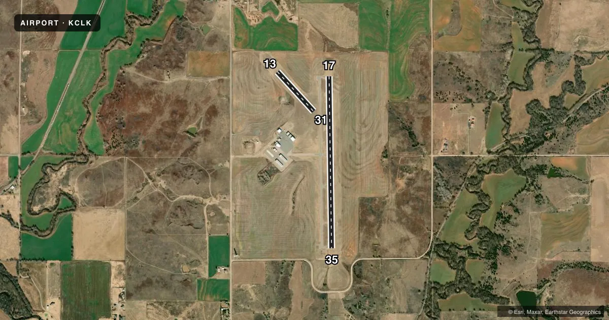
Runways & pattern
Full pagePattern entry · RWY 17
LEFT TRAFFIC| Runway | Heading (°M) | Length | Surface | Traffic |
|---|---|---|---|---|
| 17/35Favored | 172° / 352° | 4,305 ft | ASPH | Standard L |
| 13/31 | 130° / 310° | 1,348 ft | TURF | Standard L |
Runway end performance
| End | TORA | TODA | ASDA | LDA | VGSI | Approach lights | Obstruction |
|---|---|---|---|---|---|---|---|
| 17 | — | — | — | — | PAPI 4-box left(3°) | — | — |
| 35 | — | — | — | — | PAPI 4-box right(3°) | — | — |
Declared distances in feet. TORA = takeoff run available, TODA = takeoff distance, ASDA = accelerate-stop, LDA = landing distance.
Airport sketch
Runways drawn to scale from FAA survey coordinates, rendered over satellite imagery. Not for navigation.
Approaches & charts
Services on the field
Fuel grades, oxygen, maintenance, ramp storage and lighting — as declared to the FAA by the airport operator.
Fuel & services
- Fuel
- 100LLA+
- Oxygen (bottled)
- Not available
- Oxygen (bulk)
- Not available
- Airframe repair
- Major
- Power plant repair
- Major
- Other services
- AGRI,INSTR,RNTL,SALES
Ramp & ground
- Transient storage
- Tie-down
- Hangar
- Landing fee
- No fee published
- Customs
- Not available
- Lighting schedule
- SEE RMK
- Beacon schedule
- SS-SR
- Beacon
- White / Green (civil land)(WG)
- Wind indicator
- Lighted
- Segmented circle
- Yes
Fuel & FBOs
Cheapest 100LL and Jet A on the field and nearby. Always confirm with the FBO before taxi.
Airport notes
Surface conditions, obstructions, local procedures, lighting outages and other notes published with each FAA cycle.
General notes
- FOR CD CTC FORT WORTH ARTCC AT 817-858-7584.
Lighting notes
- ACTVT & INCR INTST REIL RWY 17 & 35 - CTAF. PAPI RWY 17 & 35 ON CONSLY. MIRL RWY 17/35; TWY LGTS ON LOW INTST DUSK-DAWN; INCR INTST - CTAF.
Fuel notes
- 100LL100LL FUEL AVBL 24 HRS - SELF SVC.
Approach & departure obstructions
- 13ORANGE BARRELS MKD BOUNDARIES.
- 31ORANGE BARRELS MKD BOUNDARIES.
Other notes
- PRE DATES THE ACT.
- MANAGERAFT HRS FONE NR - 580-445-1379.
VFR map & nearby airports
VFR sectional. Tap any ICAO chip to open that airport.
Key facts · KCLK
Answer card- ICAO
- KCLK
- Name
- CLINTON RGNL
- Location
- CLINTON, OKLAHOMA
- Elevation
- 1,615.5 ft MSL
- Traffic pattern altitude
- 2,615.5 ft MSL (1,000 AGL)
- Control tower
- Non-towered (use CTAF)
- Total runways
- 2
- Longest runway
- 17/35 · 4,305 ft
- Published ILS approaches
- 0
- Published frequencies
- 2
- Magnetic variation
- 7°
- Current flight rules
- VFR
- Current wind
- 210° at 7 kt
- Favored runway now
- RWY 17
Clinton Rgnl sits in Clinton, Oklahoma. Field elevation is 1,615.5 ft MSL. The airport has two runways. The longest is runway 17/35 at 4,305 ft. Runway 13/31 is turf and measures 1,348 ft. There is no control tower. CTAF and UNICOM are both 122.8. No ILS approaches are published here.
Pattern altitude is not published. Use the standard 1,000 ft AGL for light piston traffic unless the current Chart Supplement says otherwise. That puts the pattern around 2,615.5 ft MSL based on the field elevation. The airport predates the tower era. That usually means you should expect a simple non-towered flow. Keep your radio work tight.
Clinton Regional Airport is the on-field FBO. It carries 100LL and Jet A. 100LL is available 24 hours by self-service. For clearance delivery, contact Fort Worth ARTCC. The published remarks also note orange barrels at the ends of runways 13 and 31. Runway 17/35 has medium intensity lights, PAPI and runway end identifier lights. Those lights are activated by CTAF. Taxiway lights are low intensity from dusk to dawn. They increase with CTAF activation. Check the current Chart Supplement for any updated local procedures before you go.