METAR & TAF 86F
86F does not publish a METAR.
Showing the nearest reporting station: KHBR (HOBART RGNL) · 24.8 NM away. Conditions at 86F may differ.
METAR · KHBR
Observed 14:53Z
KHBR 261453Z AUTO 22013KT 10SM CLR 32/19 A3002 RMK AO2 SLP141 T03220189 51008
- Wind
- 220° @ 13 kt
- Visibility
- 10 SM
- Temp / Dew
- 32°C / 19°C
- Altimeter
- 30.02 inHg
- Clouds
- CLR
- Density alt
- 3,595 ft
- Ceiling
- Unlimited
- Rules
- VFR
Airport info & contacts
Manager on record, flight service, ARTCC, attendance schedule and pattern altitude — published by the FAA and refreshed every 28 days.
Location
- From city
- 2 NM NE
- VFR sectional
- DALLAS-FT WORTH
- ARTCC
- ZFW · FORT WORTH
- NOTAM facility
- MLC (NOTAM-D)
Airport manager
- Name
- ROBERT PETTIT
- Phone
- (580) 574-3140
- Address
- 30150 COUNTY STREET 2475, CARNEGIE OK 73015
Flight service · Hours
- FSS MLC
- MC ALESTER1-800-WX-BRIEF
- Attendance
- Unattended
Frequencies
Tap any row to copy the frequency to your clipboard.
Runways & pattern
Full pagePattern entry · RWY 17
LEFT TRAFFICRunway end performance
| End | TORA | TODA | ASDA | LDA | VGSI | Approach lights | Obstruction |
|---|---|---|---|---|---|---|---|
| 17 | — | — | — | — | PAPI 2-box left(3°) | — | — |
| 35 | — | — | — | — | PAPI 2-box right(3°) | — | — |
Declared distances in feet. TORA = takeoff run available, TODA = takeoff distance, ASDA = accelerate-stop, LDA = landing distance.
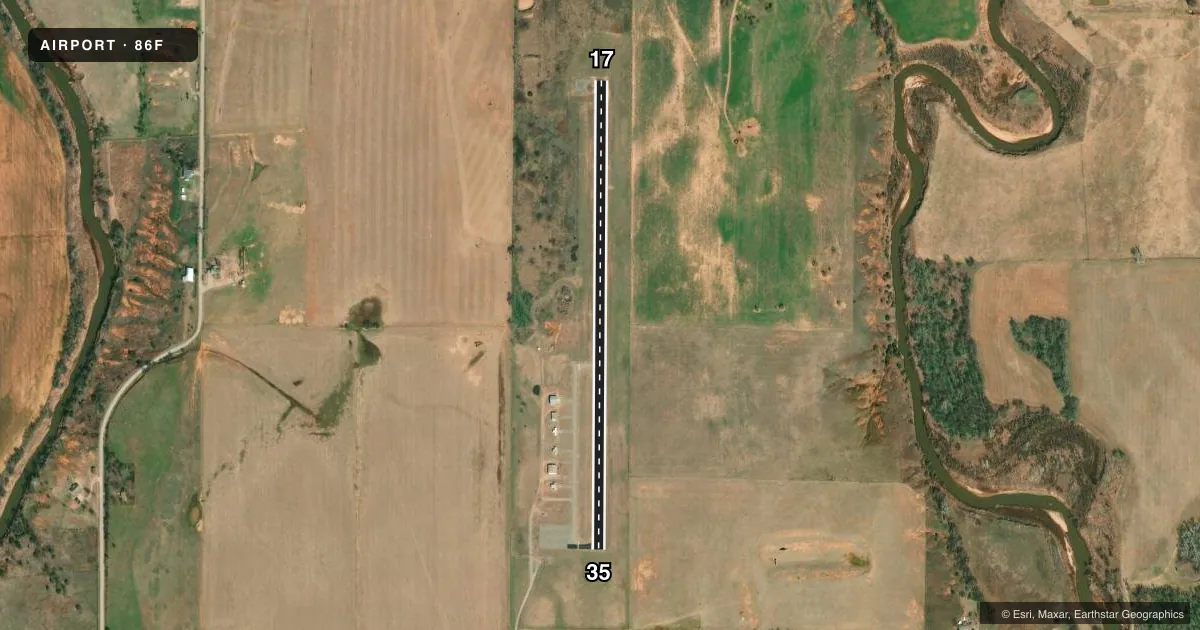
Airport sketch
Runways drawn to scale from FAA survey coordinates, rendered over satellite imagery. Not for navigation.
Approaches & charts
Services on the field
Fuel grades, oxygen, maintenance, ramp storage and lighting — as declared to the FAA by the airport operator.
Fuel & services
- Fuel
- Not available
- Oxygen (bottled)
- Not available
- Oxygen (bulk)
- Not available
- Airframe repair
- Not available
- Power plant repair
- Not available
- Other services
- AGRI
Ramp & ground
- Transient storage
- Tie-down
- Landing fee
- No fee published
- Customs
- Not available
- Lighting schedule
- SEE RMK
- Beacon schedule
- SS-SR
- Beacon
- White / Green (civil land)(WG)
- Wind indicator
- Yes
- Segmented circle
- No
Fuel & FBOs
Cheapest 100LL and Jet A on the field and nearby. Always confirm with the FBO before taxi.
Airport notes
Surface conditions, obstructions, local procedures, lighting outages and other notes published with each FAA cycle.
General notes
- FOR CD CTC FORT WORTH ARTCC AT 817-858-7584.
Lighting notes
- ACTVT MIRL RWY 17/35 - CTAF. PAPI RWY 17 & 35 ON CONSLY.
VFR map & nearby airports
VFR sectional. Tap any ICAO chip to open that airport.
Key facts · 86F
Answer card- ICAO
- 86F
- Name
- CARNEGIE MUNI
- Location
- CARNEGIE, OKLAHOMA
- Elevation
- 1,354 ft MSL
- Traffic pattern altitude
- 2,354 ft MSL (1,000 AGL)
- Control tower
- Non-towered (use CTAF)
- Total runways
- 1
- Longest runway
- 17/35 · 3,000 ft
- Published ILS approaches
- 0
- Published frequencies
- 1
- Magnetic variation
- 7°
- Current flight rules
- VFR
- Current wind
- 220° at 13 kt
- Favored runway now
- RWY 17
Carnegie Muni (86F) sits in Carnegie, Oklahoma. Field elevation is 1,354 ft MSL. The airport has one runway. Runway 17/35 is 3,000 ft long with asphalt-concrete pavement. The field is nontowered, so self-announcing on CTAF 122.9 is the normal flow.
No ILS approaches are published here. Pattern altitude is not published, so use the standard 1,000 ft AGL for light piston traffic unless the current Chart Supplement says otherwise. The runway lights on 17/35 are activated by CTAF. The precision approach path indicators on both runway ends are on continuously. That helps at night or in low visibility, but you still need to verify the runway and approach setup before you descend.
For clearance delivery, contact Fort Worth ARTCC at 817-858-7584. There are no on-field FBOs listed in the facts, so call the airport operator directly or the field on CTAF for current services before you go. This is a simple single-runway airport, but the elevation is high enough to keep density altitude in mind on warm days. Check the current Chart Supplement for any published noise or operational notes before flying in.