METAR & TAF F68
F68 does not publish a METAR.
Showing the nearest reporting station: KCHK (CHICKASHA MUNI) · 14.8 NM away. Conditions at F68 may differ.
METAR · KCHK
Observed 16:15Z
KCHK 271615Z AUTO 23013KT 10SM CLR 36/19 A2994 RMK AO2
- Wind
- 230° @ 13 kt
- Visibility
- 10 SM
- Temp / Dew
- 36°C / 19°C
- Altimeter
- 29.94 inHg
- Clouds
- CLR
- Density alt
- 4,096 ft
- Ceiling
- Unlimited
- Rules
- VFR
Airport info & contacts
Manager on record, flight service, ARTCC, attendance schedule and pattern altitude — published by the FAA and refreshed every 28 days.
Location
- From city
- 2 NM SW
- VFR sectional
- DALLAS-FT WORTH
- ARTCC
- ZFW · FORT WORTH
- NOTAM facility
- MLC (NOTAM-D)
Airport manager
- Name
- JANICE CAIN
- Phone
- 405-247-2483
- Address
- 501 WEST VIRGINIA, ANADARKO OK 73005
Flight service · Hours
- FSS MLC
- MC ALESTER1-800-WX-BRIEF
- Attendance
- Unattended
Frequencies
Tap any row to copy the frequency to your clipboard.
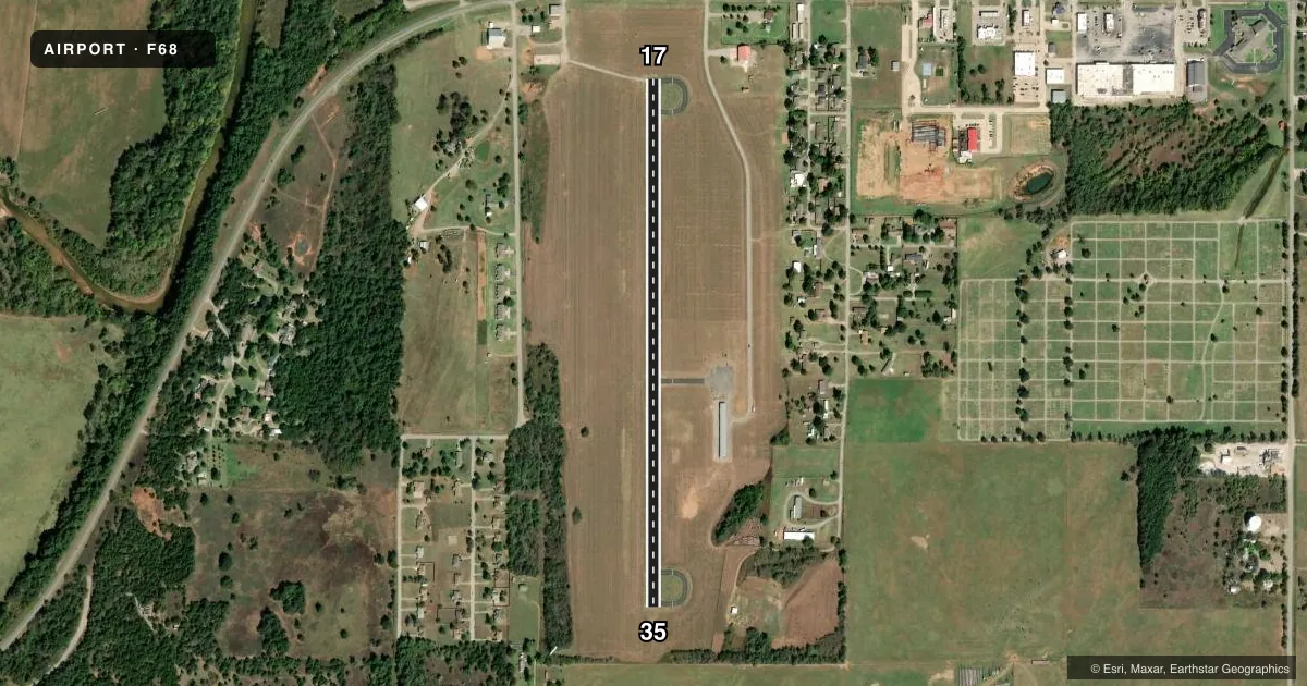
Runways & pattern
Full pagePattern entry · RWY 17
LEFT TRAFFICRunway end performance
| End | TORA | TODA | ASDA | LDA | VGSI | Approach lights | Obstruction |
|---|---|---|---|---|---|---|---|
| 17 | — | — | — | — | — | — | 15', road, 471' from thr, 0' R of cntrln, slope 18 |
| 35 | — | — | — | — | — | — | 27', trees, 304' from thr, 99' R of cntrln, slope 3 |
Declared distances in feet. TORA = takeoff run available, TODA = takeoff distance, ASDA = accelerate-stop, LDA = landing distance.
Airport sketch
Runways drawn to scale from FAA survey coordinates, rendered over satellite imagery. Not for navigation.
Approaches & charts
Services on the field
Fuel grades, oxygen, maintenance, ramp storage and lighting — as declared to the FAA by the airport operator.
Fuel & services
- Fuel
- Not available
- Oxygen (bottled)
- Not available
- Oxygen (bulk)
- Not available
- Airframe repair
- Not available
- Power plant repair
- Not available
- Other services
- AGRI
Ramp & ground
- Transient storage
- Tie-down
- Landing fee
- No fee published
- Customs
- Not available
- Lighting schedule
- SEE RMK
- Beacon schedule
- SS-SR
- Beacon
- White / Green (civil land)(WG)
- Wind indicator
- Lighted
- Segmented circle
- Yes
Fuel & FBOs
Cheapest 100LL and Jet A on the field and nearby. Always confirm with the FBO before taxi.
Airport notes
Surface conditions, obstructions, local procedures, lighting outages and other notes published with each FAA cycle.
General notes
- FOR CD CTC FORT WORTH ARTCC AT 817-858-7584.
Lighting notes
- MIRL RWY 17/35 PRESET LOW INTENSITY TO INCREASE - CTAF.
Other notes
- ESTAB PRIOR TO 1959.
- MANAGERCITY MANAGER, OR CONTACT SKIP WILKERSON 405-933-1756.
VFR map & nearby airports
VFR sectional. Tap any ICAO chip to open that airport.
Key facts · F68
Answer card- ICAO
- F68
- Name
- ANADARKO MUNI
- Location
- ANADARKO, OKLAHOMA
- Elevation
- 1,291 ft MSL
- Traffic pattern altitude
- 2,291 ft MSL (1,000 AGL)
- Control tower
- Non-towered (use CTAF)
- Total runways
- 1
- Longest runway
- 17/35 · 3,100 ft
- Published ILS approaches
- 0
- Published frequencies
- 1
- Magnetic variation
- 7°
- Current flight rules
- VFR
- Current wind
- 230° at 13 kt
- Favored runway now
- RWY 17
Anadarko Muni sits in Anadarko, Oklahoma. Field elevation is 1,291 ft MSL. The airport has one runway. Runway 17/35 is 3,100 ft asphalt, so plan performance with that length in mind. There is no control tower. CTAF is 122.9.
No ILS approaches are published here. The pattern altitude is not published in the facts, so use standard traffic pattern planning unless the current Chart Supplement says otherwise. Magnetic variation is 7°. The runway lights on 17/35 are medium intensity. They come up at low intensity by default. Use the CTAF to increase them if needed.
There are no on-field FBOs listed in the facts. Contact the airport operator directly before arrival if you need fuel or ramp details. The published manager contact is Skip Wilkerson at 405-933-1756. For clearance delivery, contact Fort Worth ARTCC at 817-858-7584. This field has been established since before 1959, so expect a small local airport with basic services rather than a busy airline setup. Check the current FAA Chart Supplement for any updated operational notes before you go.