METAR & TAF KRQO
Current METAR
Observed 16:55Z
KRQO 271655Z AUTO 24015KT 10SM CLR 38/17 A2992 RMK AO2 PWINO
- Wind
- 240° @ 15 kt
- Visibility
- 10 SM
- Temp / Dew
- 38°C / 17°C
- Altimeter
- 29.92 inHg
- Clouds
- CLR
- Density alt
- 4,521 ft
- Ceiling
- Unlimited
- Rules
- VFR
Airport info & contacts
Manager on record, flight service, ARTCC, attendance schedule and pattern altitude — published by the FAA and refreshed every 28 days.
Location
- From city
- 4 NM SW
- VFR sectional
- DALLAS-FT WORTH
- ARTCC
- ZFW · FORT WORTH
- NOTAM facility
- RQO (NOTAM-D)
Airport manager
- Name
- SCOTT LAW
- Phone
- 405-295-9343
- Address
- PO BOX 700, EL RENO OK 73036
Flight service · Hours
- FSS MLC
- MC ALESTER1-800-WX-BRIEF
- Attendance
- MON - FRI · 0800-1700
- SAT-SUN · 0900-1600
Frequencies
Tap any row to copy the frequency to your clipboard.
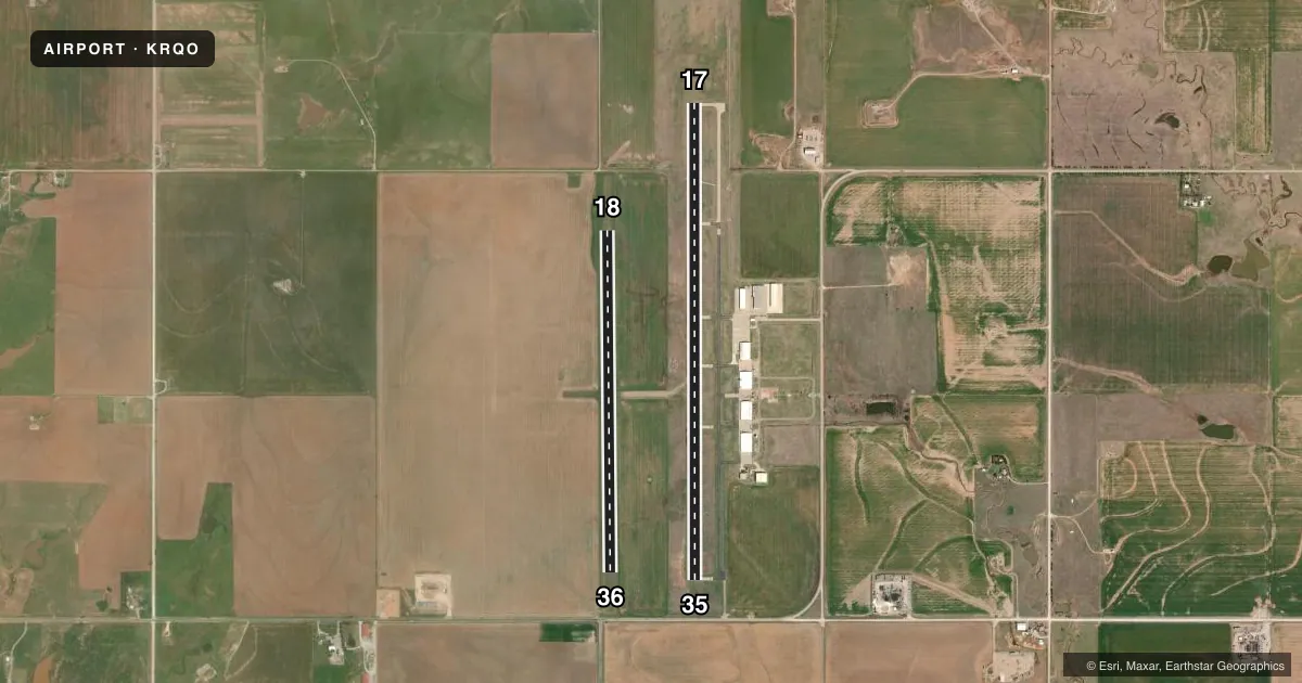
Runways & pattern
Full pagePattern entry · RWY 17
LEFT TRAFFIC| Runway | Heading (°M) | Length | Surface | Traffic |
|---|---|---|---|---|
| 17/35Favored | 176° / 356° | 5,600 ft | CONC | 35 R |
| 18/36 | 175° / 355° | 4,017 ft | TURF | 18 R |
Runway end performance
| End | TORA | TODA | ASDA | LDA | VGSI | Approach lights | Obstruction |
|---|---|---|---|---|---|---|---|
| 17 | — | — | — | — | PAPI 4-box left(3°) | — | 51', pline, 1855' from thr, 0' R of cntrln, slope 32 |
| 35 | — | — | — | — | PAPI 4-box left(3°) | — | 12', road, 450' from thr, 0' R of cntrln, slope 20 |
| 18 | — | — | — | — | — | — | 15', road, 280' from thr, 90' R of cntrln, slope 18 |
| 36 | — | — | — | — | — | — | 25', pline, 360' from thr, 95' R of cntrln, slope 14 |
Declared distances in feet. TORA = takeoff run available, TODA = takeoff distance, ASDA = accelerate-stop, LDA = landing distance.
Airport sketch
Runways drawn to scale from FAA survey coordinates, rendered over satellite imagery. Not for navigation.
Approaches & charts
Services on the field
Fuel grades, oxygen, maintenance, ramp storage and lighting — as declared to the FAA by the airport operator.
Fuel & services
- Fuel
- 100LLA+
- Airframe repair
- Major
- Power plant repair
- Major
- Other services
- AGRI,AVNCS,INSTR,SALES
Ramp & ground
- Transient storage
- Tie-down
- Hangar
- Landing fee
- No fee published
- Customs
- Not available
- Lighting schedule
- SEE RMK
- Beacon schedule
- SS-SR
- Beacon
- White / Green (civil land)(WG)
- Wind indicator
- Lighted
- Segmented circle
- Yes
Fuel & FBOs
Cheapest 100LL and Jet A on the field and nearby. Always confirm with the FBO before taxi.
Airport notes
Surface conditions, obstructions, local procedures, lighting outages and other notes published with each FAA cycle.
General notes
- FOR CD CTC OKE CITY APCH AT 405-681-5683.
Lighting notes
- ACTVT REIL RWY 17 & 35; MIRL RWY 17/35 - CTAF. PAPI RWY 17 & 35 OPR CONSLY.
Fuel notes
- 100LLAVBL H24 WITH CREDIT CARD.
- A+FULL SVC AVBL.
Other notes
- MANAGERAFT HRS CTC: 405-520-2442.
VFR map & nearby airports
VFR sectional. Tap any ICAO chip to open that airport.
Key facts · KRQO
Answer card- ICAO
- KRQO
- Name
- EL RENO RGNL
- Location
- EL RENO, OKLAHOMA
- Elevation
- 1,420.4 ft MSL
- Traffic pattern altitude
- 2,420.4 ft MSL (1,000 AGL)
- Control tower
- Non-towered (use CTAF)
- Total runways
- 2
- Longest runway
- 17/35 · 5,600 ft
- Published ILS approaches
- 0
- Published frequencies
- 4
- Magnetic variation
- 4°
- Current flight rules
- VFR
- Current wind
- 240° at 15 kt
- Favored runway now
- RWY 17
El Reno Regional Airport sits in El Reno, Oklahoma. Field elevation is 1,420.4 ft MSL. The airport has two runways. The longest is runway 17/35 at 5,600 ft of concrete. Runway 18/36 is 4,017 ft of turf. There is no control tower, so expect CTAF traffic flow and self-announced position reports. Pattern altitude is not published. For a light piston, plan on the standard 1,000 ft AGL unless the current Chart Supplement says otherwise.
No ILS approaches are published here. That matters if the weather is dropping or if you want an instrument backup. Check the current Chart Supplement before you go. The published frequencies include CTAF and UNICOM on 122.8. Oke City Approach also handles approach and departure work on 124.6 and 266.8. For clearance delivery, the published contact is Oke City Approach at 405-681-5683.
El Reno Regional Airport is the on-field FBO. It carries AVGAS 100LL and Jet A. Full service is available. 100LL is available 24 hours with credit card. Runway 17 and 35 have active runway end identifier lights. The medium intensity lights on those runways are controlled by CTAF. Precision approach path indicators on 17 and 35 operate continuously. After hours contact is 405-520-2442.