METAR & TAF KOKC
Current METAR
Observed 14:52Z
KOKC 271452Z 22010G17KT 10SM CLR 32/18 A2994 RMK AO2 SLP118 T03220183 53005
- Wind
- 220° @ 10G17 kt
- Visibility
- 10 SM
- Temp / Dew
- 32°C / 18°C
- Altimeter
- 29.94 inHg
- Clouds
- CLR
- Density alt
- 3,622 ft
- Ceiling
- Unlimited
- Rules
- VFR
Airport info & contacts
Manager on record, flight service, ARTCC, attendance schedule and pattern altitude — published by the FAA and refreshed every 28 days.
Location
- From city
- 6 NM SW
- VFR sectional
- DALLAS-FT WORTH
- ARTCC
- ZFW · FORT WORTH
- NOTAM facility
- OKC (NOTAM-D)
Airport manager
- Name
- JEFF MULDER
- Phone
- 405-623-3007
- Address
- 7100 TERMINAL DR; BOX 937, OKLAHOMA CITY OK 73159-0937
Flight service · Hours
- FSS MLC
- MC ALESTER1-800-WX-BRIEF
- Attendance
- ALL
Frequencies
Tap any row to copy the frequency to your clipboard.
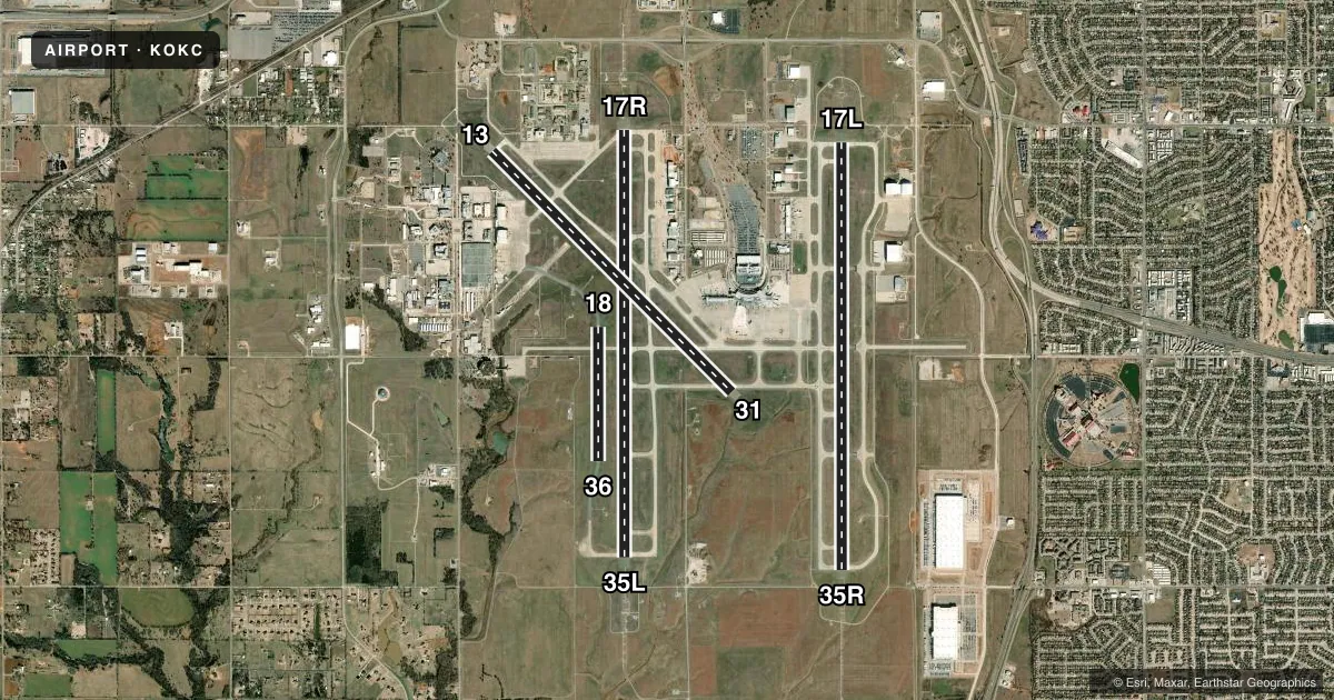
Runways & pattern
Full pagePattern entry · RWY 17L
LEFT TRAFFIC| Runway | Heading (°M) | Length | Surface | Traffic |
|---|---|---|---|---|
| 17L/35RFavored | 176° / 356° | 9,802 ft | CONC | 35R R |
| 17R/35L | 176° / 356° | 9,801 ft | CONC | 17R R |
| 13/31 | 131° / 311° | 7,800 ft | CONC | 13 R |
| 18/36 | 176° / 356° | 3,079 ft | ASPH | 18 R |
Runway end performance
| End | TORA | TODA | ASDA | LDA | VGSI | Approach lights | Obstruction |
|---|---|---|---|---|---|---|---|
| 17L | 9,802' | 9,802' | 9,802' | 9,802' | PAPI 4-box left(3°) | MALSR | — |
| 35R | 9,802' | 9,802' | 9,802' | 9,802' | PAPI 4-box left(2.9°) | ALSF2 | — |
| 17R | 9,800' | 9,800' | 9,800' | 9,800' | PAPI 4-box left(3°) | MALSR | — |
| 35L | 9,800' | 9,800' | 9,800' | 9,800' | — | MALSR | — |
| 13 | 7,800' | 7,800' | 7,800' | 7,800' | PAPI 4-box left(3°) | — | — |
| 31 | 7,800' | 7,800' | 7,800' | 7,800' | PAPI 4-box left(3°) | — | — |
| 18 | 3,079' | 3,079' | 3,079' | 3,079' | — | — | — |
| 36 | 3,079' | 3,079' | 3,079' | 3,079' | — | — | — |
Declared distances in feet. TORA = takeoff run available, TODA = takeoff distance, ASDA = accelerate-stop, LDA = landing distance.
Airport sketch
Runways drawn to scale from FAA survey coordinates, rendered over satellite imagery. Not for navigation.
Approaches & charts
ILS · 4
Services on the field
Fuel grades, oxygen, maintenance, ramp storage and lighting — as declared to the FAA by the airport operator.
Fuel & services
- Fuel
- 100LLA
- Oxygen (bottled)
- HIGH/LOW
- Oxygen (bulk)
- HIGH/LOW
- Airframe repair
- Major
- Power plant repair
- Major
- Other services
- AFRT,AVNCS,CARGO,CHTR,INSTR,RNTL,SALES
Ramp & ground
- Transient storage
- Tie-down
- Hangar
- Landing fee
- No fee published
- Customs
- Not available
- Lighting schedule
- SS-SR
- Beacon schedule
- SS-SR
- Beacon
- White / Green (civil land)(WG)
- Wind indicator
- Lighted
- Segmented circle
- No
Fuel & FBOs
Cheapest 100LL and Jet A on the field and nearby. Always confirm with the FBO before taxi.
Airport notes
Surface conditions, obstructions, local procedures, lighting outages and other notes published with each FAA cycle.
General notes
- RY 18/36 USED AS TWY WHEN NOT USED AS RY.
- RSTD: FAA AERONAUTICAL CENTER RAMP PHONE 405-954-9783 AND EMAIL MXC@FAA.GOV.
- RY 18/36 600 FT WEST OF RY 17R/35L ON EXISTING TWY.
- TWY G WEST OF RWY 17R/35L, TWY A2 EAST OF TWY A, TWY D SOUTHWEST OF RWY 13/31, TWYS: A1, B, AND C2 NOT AVBL FOR PART 121/PART 380 OPS WITH SKED PAX CARRYING OPS MORE THAN 9 PAX SEATS AND NON-SKED PAX CARRYING OPS MORE THAN 30 PAX SEATS.
- TWY G WEST OF TWY B CLSD TO ALL EXCEPT U.S. MARSHALS SERVICE ACFT.
- TWY C2 CLSD TO ALL OPNS EXCEPT METRO TECH TFC.
- ALL RAMPS ARE UNCONTROLLED.
- RY 18/36 VFR DALGT OPNS ONLY EXCEPT FOR AIR NATIONAL GUARD.
- FLIGHT NOTIFICATION SERVICE (ADCUS) AVBL.
- COMPASS ROSE RSTRD TO ACFT UNDER 95000 LBS EXCP PPR, PHONE 405-623-3007. TWY B NORTH OF COMPASS ROSE RSTRD TO ACFT UNDER 120000 LBS EXCP PPR, PHONE 405-623-3007.
- PILOTS OF ACFT WITH WING SPANS GREATER THAN 118 FT MUST USE JUDGMENTAL OVER STEERING AT ALL TWY INTXNS.
- TWYS H2 AND G EAST OF TWY H CLSD INDEFLY.
- NUMEROUS BIRDS ON & INVOF ARPT.
- MIL: SVC: FUEL A, A+ (405-218-3000 EXT 1) (NC-100LL).
- PILOTS CONDUCTING EFVS OPS; BE AWARE LED ALS IN USE RWY 17L & RWY 35L.
Runway surface & condition
- 13/31PCR VALUE: 1220/R/C/W/T
- 17L/35RPCR VALUE: 1210/R/B/W/T
- 17R/35LPCR VALUE: 1210/R/B/W/T
- 18/36PCR VALUE: 560/F/C/W/T
- 18/36RWY 18/36 NOT AVBL FOR PART 121/PART 380 OPS WITH SKED PAX CARRYING OPS MORE THAN 9 PAX SEATS AND NON-SKED PAX CARRYING OPS MORE THAN 30 PAX SEATS.
Approach & departure obstructions
- 17RPAPI UNUSBL 4 DEGS RIGHT OF RWY CNTRLN.
Other notes
- EXISTED PRIOR TO 1959.
VFR map & nearby airports
VFR sectional. Tap any ICAO chip to open that airport.
Key facts · KOKC
Answer card- ICAO
- KOKC
- Name
- OKC WILL ROGERS INTL
- Location
- OKLAHOMA CITY, OKLAHOMA
- Elevation
- 1,295.5 ft MSL
- Traffic pattern altitude
- 2,295.5 ft MSL (1,000 AGL)
- Control tower
- Towered · 24
- Total runways
- 4
- Longest runway
- 17L/35R · 9,802 ft
- Published ILS approaches
- 4
- Published frequencies
- 22
- Magnetic variation
- 4°
- Current flight rules
- VFR
- Current wind
- 220° at 10 kt
- Favored runway now
- RWY 17L
KOKC is OKC Will Rogers Intl in Oklahoma City, Oklahoma. The field elevation is 1,295.5 ft MSL. It has 4 runways. The longest is 9,802 ft. The tower is open 24 hours. Four ILS approaches are published for the 17L, 17R, 35L and 35R ends. Pattern altitude is not published. Use 1,000 ft AGL for light piston traffic unless ATC or the current Chart Supplement says otherwise.
This is a busy Class C field with multiple long concrete runways. That setup works well for turbine traffic. It also means taxi discipline matters. Taxiway G west of taxiway B is closed to all except U.S. Marshals Service aircraft. Taxiways H2 and G east of taxiway H are closed indefinitely. Large aircraft have more limits too. Wingspans over 118 ft require judgmental over steering at taxiway intersections.
On the field, Atlantic Aviation carries 100LL and Jet A. AAR Aircraft Services carries 100LL, Jet A and Jet A Prist. Runway 18/36 is daylight VFR only except for Air National Guard use. It is also used as a taxiway when not active. The PAPI on 17R is unusable 4 degrees right of centerline. Check the current Chart Supplement for any noise or curfew restrictions before flying in.