METAR & TAF KHSD
Current METAR
Observed 13:15Z
KHSD 271315Z AUTO 20012KT 10SM CLR 28/18 A2990 RMK A01
- Wind
- 200° @ 12 kt
- Visibility
- 10 SM
- Temp / Dew
- 28°C / 18°C
- Altimeter
- 29.90 inHg
- Clouds
- CLR
- Density alt
- 3,064 ft
- Ceiling
- Unlimited
- Rules
- VFR
Airport info & contacts
Manager on record, flight service, ARTCC, attendance schedule and pattern altitude — published by the FAA and refreshed every 28 days.
Location
- From city
- 12 NM NW
- VFR sectional
- DALLAS-FT WORTH
- ARTCC
- ZFW · FORT WORTH
- NOTAM facility
- HSD (NOTAM-D)
Airport manager
- Name
- BILL EICHHORN
- Phone
- 405-568-1663
- Address
- 13000 N. SARA RD., YUKON OK 73099
Flight service · Hours
- FSS MLC
- MC ALESTER1-800-WX-BRIEF
- Attendance
- 0800-1800
Frequencies
Tap any row to copy the frequency to your clipboard.
Runways & pattern
Full pagePattern entry · RWY 18
RIGHT TRAFFICRunway end performance
| End | TORA | TODA | ASDA | LDA | VGSI | Approach lights | Obstruction |
|---|---|---|---|---|---|---|---|
| 18 | — | — | — | — | VASI 2-box left(3°) | — | — |
| 36 | — | — | — | — | VASI 2-box left(3°) | — | 19', trees, 382' from thr, 135' R of cntrln, slope 9 |
Declared distances in feet. TORA = takeoff run available, TODA = takeoff distance, ASDA = accelerate-stop, LDA = landing distance.
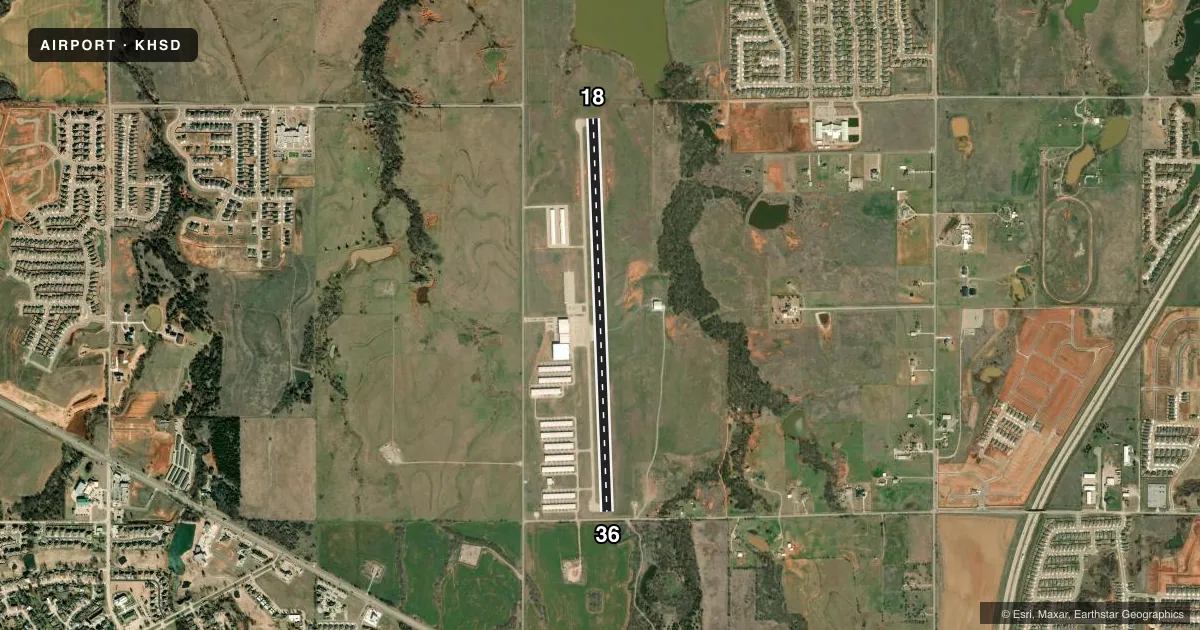
Airport sketch
Runways drawn to scale from FAA survey coordinates, rendered over satellite imagery. Not for navigation.
Approaches & charts
Services on the field
Fuel grades, oxygen, maintenance, ramp storage and lighting — as declared to the FAA by the airport operator.
Fuel & services
- Fuel
- 100LLA+
- Oxygen (bulk)
- HIGH/LOW
- Airframe repair
- Major
- Power plant repair
- Major
- Other services
- INSTR
Ramp & ground
- Transient storage
- Tie-down
- Hangar
- Lighting schedule
- SEE RMK
- Beacon schedule
- SS-SR
- Beacon
- White / Green (civil land)(WG)
- Wind indicator
- Lighted
- Segmented circle
- No
Fuel & FBOs
Cheapest 100LL and Jet A on the field and nearby. Always confirm with the FBO before taxi.
Airport notes
Surface conditions, obstructions, local procedures, lighting outages and other notes published with each FAA cycle.
General notes
- FOR CD CTC OKE CITY APCH AT 405-681-5683.
Lighting notes
- ACTVT VASI RWY 18 & 36; MIRL RWY 18/36 - CTAF.
Fuel notes
- 100LL100LL SELF SVC AVBL 24 HR WITH CREDIT CARD.
Approach & departure obstructions
- 3610 FT ROAD AT 103 FT, 3 FT FENCE AT 65 FT, 2 FT BERM 130FT FM THLD, 17 FT TREES 120 FT FM THLD AND 150 FT RIGHT.
- 18VASI UNUSBL BYD 7 DEGS RIGHT & LEFT OF CNTRLN.
- 36VASI UNUSBL BYD 7 DEGS LEFT OF CNTLRN.
Other notes
- THIS AIRPORT HAS BEEN SURVEYED BY THE NATIONAL GEODETIC SURVEY.
- CONDL - PRVDD ALL TFC PAT OPNS SHOULD BE WEST OF THE ARPT'S N/S RWY; IE. ALL TURNS TO THE LEFT WHEN LNDG OR TAKING OFF TO THE NORTH & ALL TURNS TO THE RIGHT WHEN LNDG OR TAKING OFF TO THE SOUTH; ALL EASTBOUND DEPS SHOULD ESTAB RDO CTC WITH THE WILEY POST ATCT PRIOR TO DEP.
- AVBL DURG OPS HR MON-SAT.
- OWNERJERRY HUNTER
- MANAGEROTR FONE CTC 405-373-3886.
VFR map & nearby airports
VFR sectional. Tap any ICAO chip to open that airport.
Key facts · KHSD
Answer card- ICAO
- KHSD
- Name
- SUNDANCE
- Location
- OKLAHOMA CITY, OKLAHOMA
- Elevation
- 1,192.9 ft MSL
- Traffic pattern altitude
- 2,192.9 ft MSL (1,000 AGL)
- Control tower
- Non-towered (use CTAF)
- Total runways
- 1
- Longest runway
- 18/36 · 5,001 ft
- Published ILS approaches
- 0
- Published frequencies
- 5
- Magnetic variation
- 4°
- Current flight rules
- VFR
- Current wind
- 200° at 12 kt
- Favored runway now
- RWY 18
Sundance Airport is in Oklahoma City, Oklahoma. The field elevation is 1,192.9 ft MSL. It has one runway, 18/36, which is 5,001 ft long with concrete pavement. There is no control tower. Pattern altitude is not published, so use the standard 1,000 ft AGL for light piston operations unless the current Chart Supplement says otherwise.
No ILS approaches are published here. The airport uses CTAF 122.7 and UNICOM 122.7. Clearance delivery is on 123.7. Oke City Approach is on 124.6 and 266.8. The on-field FBO is Sundance Airport. It carries 100LL and Jet A. 100LL self-serve is available 24 hours with credit card. If you need current airport coordination, call the field directly at (405) 373-3886.
A few remarks matter for planning. Pattern operations should stay west of the north-south runway. That means left traffic to the north. Right traffic to the south. Eastbound departures should establish radio contact with Wiley Post tower before departure. The VASI is unusable beyond 7 degrees left of centerline on runway 36. On runway 18, the VASI is unusable beyond 7 degrees left and right of centerline. Runway 36 also has nearby road, fence, berm and tree obstructions near the threshold, so brief your arrival carefully.