METAR & TAF KLAW
Current METAR
Observed 12:53Z
KLAW 271253Z 19006KT 10SM CLR 26/18 A2993 RMK AO2 SLP119 T02560183
- Wind
- 190° @ 6 kt
- Visibility
- 10 SM
- Temp / Dew
- 26°C / 18°C
- Altimeter
- 29.93 inHg
- Clouds
- CLR
- Density alt
- 2,684 ft
- Ceiling
- Unlimited
- Rules
- VFR
Airport info & contacts
Manager on record, flight service, ARTCC, attendance schedule and pattern altitude — published by the FAA and refreshed every 28 days.
Location
- From city
- 2 NM S
- VFR sectional
- DALLAS-FT WORTH
- ARTCC
- ZFW · FORT WORTH
- NOTAM facility
- LAW (NOTAM-D)
Airport manager
- Name
- BARBARA MCNALLY
- Phone
- 580-353-4869
- Address
- 3401 S 11TH ST, LAWTON OK 73501
Flight service · Hours
- FSS MLC
- MC ALESTER1-800-WX-BRIEF
- Attendance
- MON-FRI · 0530-2000
- SAT-SUN · 0530-1900
Frequencies
Tap any row to copy the frequency to your clipboard.
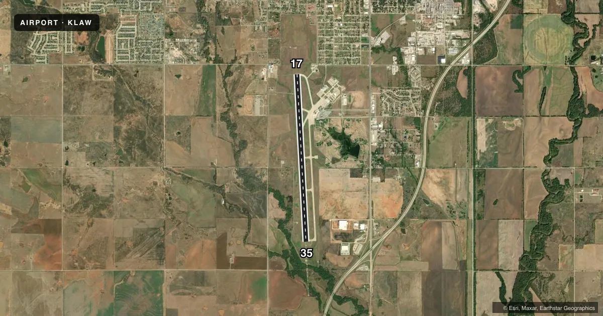
Runways & pattern
Full pagePattern entry · RWY 17
LEFT TRAFFICRunway end performance
| End | TORA | TODA | ASDA | LDA | VGSI | Approach lights | Obstruction |
|---|---|---|---|---|---|---|---|
| 17 | 8,599' | 8,599' | 8,599' | 8,599' | PAPI 4-box right(3°) | — | 72', pole, 3100' from thr, 170' R of cntrln, slope 40 |
| 35 | 8,599' | 8,599' | 8,599' | 8,599' | — | MALSR | — |
Declared distances in feet. TORA = takeoff run available, TODA = takeoff distance, ASDA = accelerate-stop, LDA = landing distance.
Airport sketch
Runways drawn to scale from FAA survey coordinates, rendered over satellite imagery. Not for navigation.
Approaches & charts
ILS · 1
Services on the field
Fuel grades, oxygen, maintenance, ramp storage and lighting — as declared to the FAA by the airport operator.
Fuel & services
- Fuel
- 100LLA1+
- Oxygen (bottled)
- Not available
- Oxygen (bulk)
- HIGH/LOW
- Airframe repair
- Major
- Power plant repair
- Major
- Other services
- AFRT,CARGO,INSTR,RNTL
Ramp & ground
- Transient storage
- Tie-down
- Hangar
- Landing fee
- No fee published
- Customs
- Not available
- Lighting schedule
- SEE RMK
- Beacon schedule
- SS-SR
- Beacon
- White / Green (civil land)(WG)
- Wind indicator
- Lighted
- Segmented circle
- Yes
Fuel & FBOs
Cheapest 100LL and Jet A on the field and nearby. Always confirm with the FBO before taxi.
Airport notes
Surface conditions, obstructions, local procedures, lighting outages and other notes published with each FAA cycle.
General notes
- WHEN ATCT CLSD ARFF AVBL THROUGH FORT SILL APCH.
- BIRDS ON & INVOF ARPT.
- WHEN ATCT CLSD, FOR CD CTC FORT WORTH ARTCC AT 817-858-7584.
Lighting notes
- ATCT CTLS ALL RWY & TWY LGTG WHEN OPEN; WHEN ATCT CLSD, MALSR RWY 35; REIL RWY 17; HIRL RWY 17/35; TWY LGTG ON MED INTST. INCR/DECR INTST - CTAF. PAPI RWY 17 ON CONSLY, VRBL INTST - CTAF.
Runway surface & condition
- 17/35PCR VALUE: 610/R/B/W/T
Other notes
- THIS AIRPORT HAS BEEN SURVEYED BY THE NATIONAL GEODETIC SURVEY.
- PRE DATES THE ACT.
- PPR FOR UNSKED PART 121 ACR OPS WITH MORE THAN 30 PAX SEATS - AMGR.
- MANAGEREXTENSION 301.
VFR map & nearby airports
VFR sectional. Tap any ICAO chip to open that airport.
Key facts · KLAW
Answer card- ICAO
- KLAW
- Name
- LAWTON-FORT SILL RGNL
- Location
- LAWTON, OKLAHOMA
- Elevation
- 1,110.3 ft MSL
- Traffic pattern altitude
- 2,110.3 ft MSL (1,000 AGL)
- Control tower
- Towered · 0800-1900
- Total runways
- 1
- Longest runway
- 17/35 · 8,599 ft
- Published ILS approaches
- 1
- Published frequencies
- 10
- Magnetic variation
- 6°
- Current flight rules
- VFR
- Current wind
- 190° at 6 kt
- Favored runway now
- RWY 17
Lawton-Fort Sill Rgnl Airport sits in Lawton, Oklahoma. Field elevation is 1,110.3 ft MSL. The airport has one runway, 17/35, which is 8,599 ft long. The tower is open from 0800 to 1900. The published ILS serves runway 35. Pattern altitude is not published, so plan on the standard 1,000 ft AGL for light piston traffic unless ATC or the current Chart Supplement says otherwise.
Lawton Aviation Services is on the field. It carries 100LL and Jet A Prist. Birds are reported on and near the airport, so keep a sharp scan on arrival and departure. When the tower is closed, runway and taxiway lighting is still available. The published remarks also note that ARFF is available through Fort Sill Approach after tower hours. That matters if you are planning a late arrival or departure. The airport sits in a controlled environment tied to Fort Sill procedures, so check current ATC and airport notes before you go. For any clearance delivery details after hours, use the current Chart Supplement or contact Fort Worth ARTCC directly. The runway is long enough for a wide range of aircraft. First-time visitors should brief the lighting setup and after-hours procedures before taxi.