METAR & TAF 3O5
3O5 does not publish a METAR.
Showing the nearest reporting station: KLAW (LAWTON-FORT SILL RGNL) · 11.7 NM away. Conditions at 3O5 may differ.
METAR · KLAW
Observed 12:53Z
KLAW 271253Z 19006KT 10SM CLR 26/18 A2993 RMK AO2 SLP119 T02560183
- Wind
- 190° @ 6 kt
- Visibility
- 10 SM
- Temp / Dew
- 26°C / 18°C
- Altimeter
- 29.93 inHg
- Clouds
- CLR
- Density alt
- 2,620 ft
- Ceiling
- Unlimited
- Rules
- VFR
Airport info & contacts
Manager on record, flight service, ARTCC, attendance schedule and pattern altitude — published by the FAA and refreshed every 28 days.
Location
- From city
- 5 NM W
- VFR sectional
- DALLAS-FT WORTH
- ARTCC
- ZFW · FORT WORTH
- NOTAM facility
- MLC (NOTAM-D)
Airport manager
- Name
- SHAWN STRANGE
- Phone
- 580-875-3337
- Address
- PO BOX 485, WALTERS OK 73572
Flight service · Hours
- FSS MLC
- MC ALESTER1-800-WX-BRIEF
- Attendance
- Unattended
Frequencies
Tap any row to copy the frequency to your clipboard.
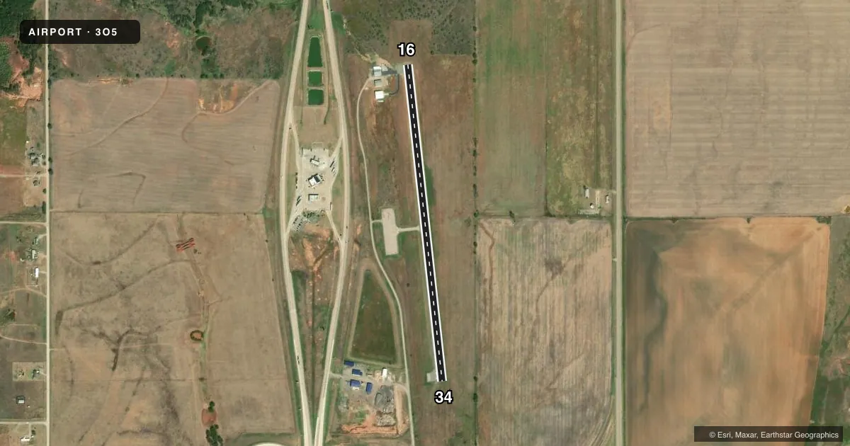
Runways & pattern
Full pagePattern entry · RWY 16
LEFT TRAFFICAirport sketch
Runways drawn to scale from FAA survey coordinates, rendered over satellite imagery. Not for navigation.
Approaches & charts
Services on the field
Fuel grades, oxygen, maintenance, ramp storage and lighting — as declared to the FAA by the airport operator.
Fuel & services
- Fuel
- Not available
- Oxygen (bottled)
- Not available
- Oxygen (bulk)
- Not available
- Airframe repair
- Not available
- Power plant repair
- Not available
- Other services
- AGRI
Ramp & ground
- Transient storage
- Tie-down
- Landing fee
- No fee published
- Customs
- Not available
- Lighting schedule
- SS-SR
- Beacon schedule
- SS-SR
- Beacon
- White / Green (civil land)(WG)
- Wind indicator
- Yes
- Segmented circle
- Yes
Fuel & FBOs
Cheapest 100LL and Jet A on the field and nearby. Always confirm with the FBO before taxi.
Airport notes
Surface conditions, obstructions, local procedures, lighting outages and other notes published with each FAA cycle.
General notes
- FOR CD CTC FORT WORTH ARTCC AT 817-858-7584.
Approach & departure obstructions
- 16RWY CNTRLN MARKINGS FADED.
Other notes
- SEGMENTED CRC SVRLY FADED.
- MANAGERCITY MANAGER.
VFR map & nearby airports
VFR sectional. Tap any ICAO chip to open that airport.
Key facts · 3O5
Answer card- ICAO
- 3O5
- Name
- WALTERS MUNI
- Location
- WALTERS, OKLAHOMA
- Elevation
- 1,058 ft MSL
- Traffic pattern altitude
- 2,058 ft MSL (1,000 AGL)
- Control tower
- Non-towered (use CTAF)
- Total runways
- 1
- Longest runway
- 16/34 · 2,900 ft
- Published ILS approaches
- 0
- Published frequencies
- 1
- Magnetic variation
- 7°
- Current flight rules
- VFR
- Current wind
- 190° at 6 kt
- Favored runway now
- RWY 16
Walters Muni sits in Walters, Oklahoma. Field elevation is 1,058 ft MSL. The airport has one runway, 16/34, with a longest usable length of 2,900 ft on asphalt. There is no control tower. CTAF is 122.9.
No ILS approaches are published here. Pattern altitude is not published, so use the standard 1,000 ft AGL for light piston operations unless the current FAA Chart Supplement says otherwise. The published remarks matter here. Runway 16 centerline markings are faded. The segmented circle is also severely faded. That makes a careful wind check and a clean pattern especially important on arrival.
There are no on-field FBOs listed. Plan on self-sufficiency and verify current services with the airport operator before you go. For clearance delivery, contact Fort Worth ARTCC at 817-858-7584. This is a non-towered field with a single short runway. It is a simple stop for light aircraft. Still, the runway length is limited. Check performance, density altitude and runway condition before you launch. If you need current local procedures or any noise or operating restrictions, verify them in the current FAA Chart Supplement before flight.