METAR & TAF KCWC
Current METAR
Observed 13:35Z
KCWC 271335Z AUTO 20006KT 10SM CLR 27/18 A2996 RMK AO2 T02730183 PWINO
- Wind
- 200° @ 6 kt
- Visibility
- 10 SM
- Temp / Dew
- 27°C / 18°C
- Altimeter
- 29.96 inHg
- Clouds
- CLR
- Density alt
- 2,634 ft
- Ceiling
- Unlimited
- Rules
- VFR
Airport info & contacts
Manager on record, flight service, ARTCC, attendance schedule and pattern altitude — published by the FAA and refreshed every 28 days.
Location
- From city
- 3 NM S
- VFR sectional
- DALLAS-FT WORTH
- ARTCC
- ZFW · FORT WORTH
- NOTAM facility
- FTW (NOTAM-D)
Airport manager
- Name
- ANDREW HOLLEY
- Phone
- 940-733-2327
- Address
- 4515 OLD JACKSBORO HWY, WICHITA FALLS TX 76302
Flight service · Hours
- FSS FTW
- FORT WORTH1-800-WX-BRIEF
- Attendance
- 0600-2000
Frequencies
Tap any row to copy the frequency to your clipboard.
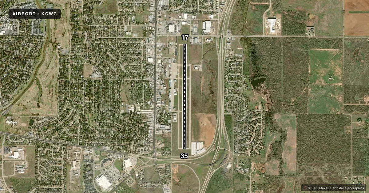
Runways & pattern
Full pagePattern entry · RWY 17
LEFT TRAFFICRunway end performance
| End | TORA | TODA | ASDA | LDA | VGSI | Approach lights | Obstruction |
|---|---|---|---|---|---|---|---|
| 17 | — | — | — | — | PAPI 4-box left(3°) | — | 5', fence, 201' from thr, 215' R of cntrln, slope 0 |
| 35 | — | — | — | — | PAPI 4-box left(3°) | — | 15', road, 314' from thr, 0' R of cntrln, slope 7 |
Declared distances in feet. TORA = takeoff run available, TODA = takeoff distance, ASDA = accelerate-stop, LDA = landing distance.
Airport sketch
Runways drawn to scale from FAA survey coordinates, rendered over satellite imagery. Not for navigation.
Approaches & charts
Services on the field
Fuel grades, oxygen, maintenance, ramp storage and lighting — as declared to the FAA by the airport operator.
Fuel & services
- Fuel
- 100LLA
- Oxygen (bottled)
- Not available
- Oxygen (bulk)
- Not available
- Airframe repair
- Major
- Power plant repair
- Major
- Other services
- INSTR,RNTL
Ramp & ground
- Transient storage
- Tie-down
- Hangar
- Landing fee
- No fee published
- Customs
- Not available
- Lighting schedule
- SEE RMK
- Beacon schedule
- SS-SR
- Beacon
- White / Green (civil land)(WG)
- Wind indicator
- Lighted
- Segmented circle
- Yes
Fuel & FBOs
Cheapest 100LL and Jet A on the field and nearby. Always confirm with the FBO before taxi.
Airport notes
Surface conditions, obstructions, local procedures, lighting outages and other notes published with each FAA cycle.
General notes
- DO NOT MISTAKE KICKAPOO DOWNTOWN FOR SHEPPARD AFB/WICHITA FALLS MUNI ARPT 7 MILES NORTH.
- INTENSIVE JET TRAINER TFC 2300-3000 FT MSL WITHIN ALERT AREA A-636. REMAIN BLO 1800 FT MSL UNTIL IN RADAR CTC WITH APCH CTL FOR TFC ADVISORIES.
- ANTS 2054 FT MSL 3.5 MI NW OF ARPT.
- FOR CD CTC FORT WORTH ARTCC AT 817-858-7584.
Lighting notes
- ACTVT REIL RWYS 17 & 35; MIRL RWY 17/35 - CTAF.
Fuel notes
- 100LLFULL & SELF SERVE 100 LL & JET A
Approach & departure obstructions
- 175 FT FENCE, 0-199 FT DSTC, 210 FT L.
- 17OBSTN CLNC SLOPE 22:1 TO DSPLCD THR OVR 14 FT RD, 320 FT DSTC.
- 35OBSTN CLNC SLOPE 37:1 TO DSPLCD THR.
VFR map & nearby airports
VFR sectional. Tap any ICAO chip to open that airport.
Key facts · KCWC
Answer card- ICAO
- KCWC
- Name
- KICKAPOO DOWNTOWN
- Location
- WICHITA FALLS, TEXAS
- Elevation
- 1,003 ft MSL
- Traffic pattern altitude
- 2,003 ft MSL (1,000 AGL)
- Control tower
- Non-towered (use CTAF)
- Total runways
- 1
- Longest runway
- 17/35 · 4,450 ft
- Published ILS approaches
- 0
- Published frequencies
- 5
- Magnetic variation
- 4°
- Current flight rules
- VFR
- Current wind
- 200° at 6 kt
- Favored runway now
- RWY 17
Kickapoo Downtown Airport sits in Wichita Falls, Texas. The field elevation is 1,003 ft MSL. It has one runway, 17/35, which is 4,450 ft long and paved with concrete. There is no control tower. CTAF and UNICOM are both 122.7. No ILS approaches are published here.
The published pattern altitude is not listed, so plan on the standard 1,000 ft AGL for light piston traffic unless the current FAA Chart Supplement says otherwise. The airport sits near busy training airspace. Published remarks say intensive jet trainer traffic operates between 2,300 and 3,000 ft MSL within Alert Area A-636. Stay below 1,800 ft MSL until you are in radar contact with approach control for traffic advisories. That matters here.
Kickapoo Downtown Airport, the on-field FBO, carries AVGAS 100LL and Jet A. Full and self-serve fuel are both published. Runway end identifier lights are on runways 17 and 35. Medium intensity runway lights are on the runway and are controlled by CTAF. Watch the published obstacle notes near both runway ends. The airport is also easy to confuse with Sheppard Air Force Base or Wichita Falls Municipal Airport, which are 7 miles north. If you need clearance delivery, contact Fort Worth ARTCC at the published number before departure.