METAR & TAF 4O1
4O1 does not publish a METAR.
Showing the nearest reporting station: KAXS (ALTUS/QUARTZ MOUNTAIN RGNL) · 16.6 NM away. Conditions at 4O1 may differ.
METAR · KAXS
Observed 13:08Z
KAXS 271308Z AUTO 16005KT 10SM CLR 26/19 A2993 RMK AO2
- Wind
- 160° @ 5 kt
- Visibility
- 10 SM
- Temp / Dew
- 26°C / 19°C
- Altimeter
- 29.93 inHg
- Clouds
- CLR
- Density alt
- 2,951 ft
- Ceiling
- Unlimited
- Rules
- VFR
Airport info & contacts
Manager on record, flight service, ARTCC, attendance schedule and pattern altitude — published by the FAA and refreshed every 28 days.
Location
- From city
- 4 NM SW
- VFR sectional
- DALLAS-FT WORTH
- ARTCC
- ZFW · FORT WORTH
- NOTAM facility
- MLC (NOTAM-D)
Airport manager
- Name
- GERALD SCHULZ
- Phone
- 580-569-2222
- Address
- PO BOX 280, SNYDER OK 73566
Flight service · Hours
- FSS MLC
- MC ALESTER1-800-WX-BRIEF
- Attendance
- IREG
Frequencies
Tap any row to copy the frequency to your clipboard.
Runways & pattern
Full pagePattern entry · RWY 17
LEFT TRAFFICRunway end performance
| End | TORA | TODA | ASDA | LDA | VGSI | Approach lights | Obstruction |
|---|---|---|---|---|---|---|---|
| 35 | — | — | — | — | — | — | 30', trees, 230' from thr, 75' R of cntrln, slope 1 |
Declared distances in feet. TORA = takeoff run available, TODA = takeoff distance, ASDA = accelerate-stop, LDA = landing distance.
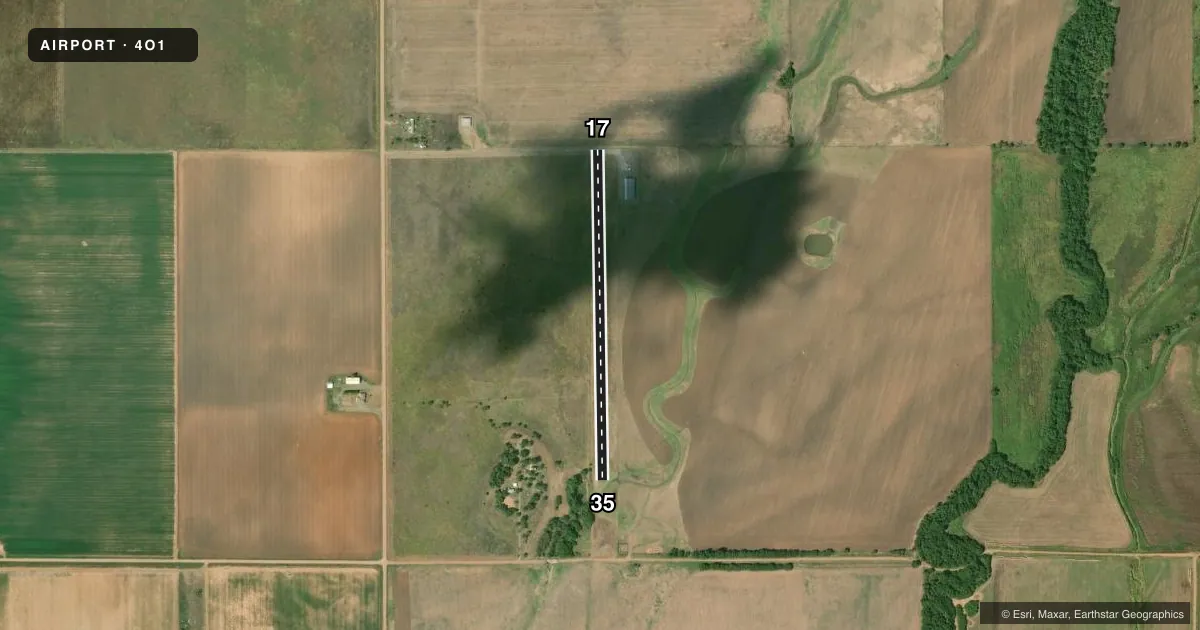
Airport sketch
Runways drawn to scale from FAA survey coordinates, rendered over satellite imagery. Not for navigation.
Approaches & charts
Services on the field
Fuel grades, oxygen, maintenance, ramp storage and lighting — as declared to the FAA by the airport operator.
Fuel & services
- Fuel
- 100LLA
- Oxygen (bottled)
- Not available
- Oxygen (bulk)
- Not available
- Airframe repair
- Not available
- Power plant repair
- Not available
- Other services
- AGRI
Ramp & ground
- Transient storage
- Hangar
- Landing fee
- No fee published
- Wind indicator
- Yes
- Segmented circle
- No
Fuel & FBOs
Cheapest 100LL and Jet A on the field and nearby. Always confirm with the FBO before taxi.
Airport notes
Surface conditions, obstructions, local procedures, lighting outages and other notes published with each FAA cycle.
General notes
- FOR CD CTC FORT WORTH ARTCC AT 817-858-7584.
Fuel notes
- 100LLFUEL AVBL ON REQ CALL 580-569-2222.
Approach & departure obstructions
- 3530 FT TREES 230 FT FM RY END AND 75 FT LEFT.
VFR map & nearby airports
VFR sectional. Tap any ICAO chip to open that airport.
Key facts · 4O1
Answer card- ICAO
- 4O1
- Name
- SNYDER
- Location
- SNYDER, OKLAHOMA
- Elevation
- 1,325 ft MSL
- Traffic pattern altitude
- 2,325 ft MSL (1,000 AGL)
- Control tower
- Non-towered (use CTAF)
- Total runways
- 1
- Longest runway
- 17/35 · 2,125 ft
- Published ILS approaches
- 0
- Published frequencies
- 1
- Magnetic variation
- 8°
- Current flight rules
- VFR
- Current wind
- 160° at 5 kt
- Favored runway now
- RWY 17
Snyder Airport (4O1) is in Snyder, Oklahoma. The field elevation is 1,325 ft MSL. It has one runway, 17/35, which is 2,125 ft long and asphalt. The airport is non-towered. CTAF is 122.9.
No ILS approaches are published here. The pattern altitude is not published, so use the standard 1,000 ft AGL for light piston operations unless the current Chart Supplement says otherwise. That puts the pattern at 2,325 ft MSL based on the field elevation, but verify the published traffic pattern guidance before you go.
Fuel is available on request. Call 580-569-2222 before arrival if you need 100LL. There are no on-field FBOs listed in the facts, so check with the airport operator or call ahead for current service details.
One published obstacle note matters on runway 35. There are 30 ft trees about 230 ft from the runway end and 75 ft left of centerline. That is worth keeping in mind on departure or landing from that end. For clearance delivery, contact Fort Worth ARTCC at 817-858-7584. Use the current Chart Supplement for any other local notes before flying in.