METAR & TAF 1K2
1K2 does not publish a METAR.
Showing the nearest reporting station: KPVJ (PAULS VALLEY MUNI) · 19.7 NM away. Conditions at 1K2 may differ.
METAR · KPVJ
Observed 13:35Z
KPVJ 271335Z AUTO 00000KT 10SM CLR 28/19 A2998 RMK AO2 T02750190 TSNO
- Wind
- 000° @ 0 kt
- Visibility
- 10 SM
- Temp / Dew
- 28°C / 19°C
- Altimeter
- 29.98 inHg
- Clouds
- CLR
- Density alt
- 2,686 ft
- Ceiling
- Unlimited
- Rules
- VFR
Airport info & contacts
Manager on record, flight service, ARTCC, attendance schedule and pattern altitude — published by the FAA and refreshed every 28 days.
Location
- From city
- 2 NM NE
- VFR sectional
- DALLAS-FT WORTH
- ARTCC
- ZFW · FORT WORTH
- NOTAM facility
- MLC (NOTAM-D)
Airport manager
- Name
- TOM INMAN
- Phone
- 405-756-2019
- Address
- PO BOX 708, 312 S. MAIN ST., LINDSAY OK 73052
Flight service · Hours
- FSS MLC
- MC ALESTER1-800-WX-BRIEF
- Attendance
- Unattended
Frequencies
Tap any row to copy the frequency to your clipboard.
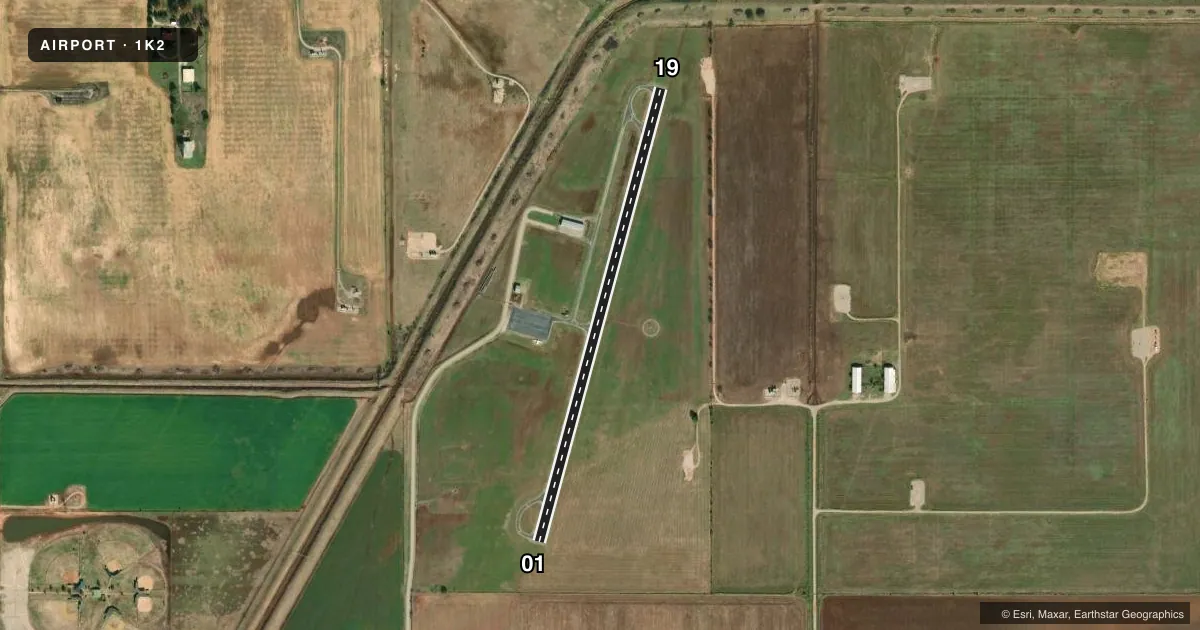
Runways & pattern
Full pagePattern entry · RWY 01
LEFT TRAFFICAirport sketch
Runways drawn to scale from FAA survey coordinates, rendered over satellite imagery. Not for navigation.
Approaches & charts
Services on the field
Fuel grades, oxygen, maintenance, ramp storage and lighting — as declared to the FAA by the airport operator.
Fuel & services
- Fuel
- Not available
- Oxygen (bottled)
- Not available
- Oxygen (bulk)
- Not available
- Airframe repair
- Not available
- Power plant repair
- Not available
Ramp & ground
- Transient storage
- Tie-down
- Landing fee
- No fee published
- Customs
- Not available
- Lighting schedule
- SEE RMK
- Beacon schedule
- SS-SR
- Beacon
- White / Green (civil land)(WG)
- Wind indicator
- Lighted
- Segmented circle
- Yes
Fuel & FBOs
Cheapest 100LL and Jet A on the field and nearby. Always confirm with the FBO before taxi.
Airport notes
Surface conditions, obstructions, local procedures, lighting outages and other notes published with each FAA cycle.
General notes
- 660 FT AGL ANT 3.2 MI NORTH.
- FOR CD CTC FORT WORTH ARTCC AT 817-858-7584.
Lighting notes
- ACTVT MIRL RY 01/19 - CTAF.
Other notes
- MANAGERCITY MANAGER.
VFR map & nearby airports
VFR sectional. Tap any ICAO chip to open that airport.
Key facts · 1K2
Answer card- ICAO
- 1K2
- Name
- LINDSAY MUNI
- Location
- LINDSAY, OKLAHOMA
- Elevation
- 968 ft MSL
- Traffic pattern altitude
- 1,968 ft MSL (1,000 AGL)
- Control tower
- Non-towered (use CTAF)
- Total runways
- 1
- Longest runway
- 01/19 · 3,010 ft
- Published ILS approaches
- 0
- Published frequencies
- 1
- Magnetic variation
- 7°
- Current flight rules
- VFR
- Current wind
- 000° at 0 kt
- Favored runway now
- –
Lindsay Muni sits in Lindsay, Oklahoma. Field elevation is 968 ft MSL. The airport has one runway. Runway 01/19 is 3,010 ft long with an asphalt surface. There is no control tower. CTAF is 122.9. No ILS approaches are published here.
Pattern altitude is not published. Use the standard 1,000 ft AGL pattern unless local procedures or the current FAA Chart Supplement say otherwise. The published remarks also note a 660 ft AGL antenna 3.2 miles north of the field. That is worth keeping in mind on departure and arrival. Medium intensity runway lights on 01/19 are activated by using the CTAF. For clearance delivery, Fort Worth Center handles it at 817-858-7584.
No on-field FBOs are listed in the facts. Contact the airport operator directly before arrival. You can also call the field on CTAF for current fuel and service availability. For a first-time visit, treat this as a non-towered field with a modest runway length and no published ILS. Plan your arrival with current weather, runway condition and traffic in mind. Check the current FAA Chart Supplement for any noise or curfew restrictions before flying into the field.