METAR & TAF 3O3
3O3 does not publish a METAR.
Showing the nearest reporting station: KOUN (UNIVERSITY OF OKLAHOMA WESTHEIMER) · 16.3 NM away. Conditions at 3O3 may differ.
METAR · KOUN
Observed 14:45Z
KOUN 271445Z 18010KT 10SM CLR 31/19 A2993
- Wind
- 180° @ 10 kt
- Visibility
- 10 SM
- Temp / Dew
- 31°C / 19°C
- Altimeter
- 29.93 inHg
- Clouds
- CLR
- Density alt
- 3,325 ft
- Ceiling
- Unlimited
- Rules
- VFR
Airport info & contacts
Manager on record, flight service, ARTCC, attendance schedule and pattern altitude — published by the FAA and refreshed every 28 days.
Location
- From city
- 2 NM SW
- VFR sectional
- DALLAS-FT WORTH
- ARTCC
- ZFW · FORT WORTH
- NOTAM facility
- MLC (NOTAM-D)
Airport manager
- Name
- ANDY PIPES
- Phone
- 405-527-6563
- Address
- 1420 CHANDLER RD., PURCELL OK 73080
Flight service · Hours
- FSS MLC
- MC ALESTER1-800-WX-BRIEF
- Attendance
- INTMT
Frequencies
Tap any row to copy the frequency to your clipboard.
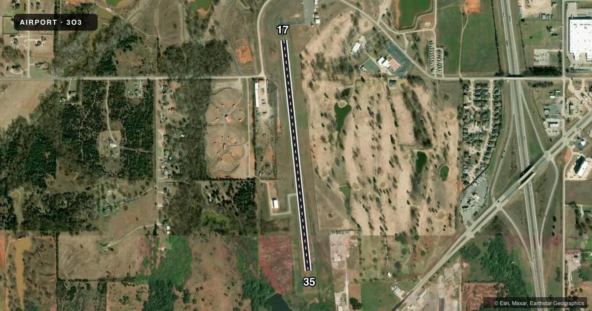
Runways & pattern
Full pagePattern entry · RWY 17
LEFT TRAFFICAirport sketch
Runways drawn to scale from FAA survey coordinates, rendered over satellite imagery. Not for navigation.
Approaches & charts
Services on the field
Fuel grades, oxygen, maintenance, ramp storage and lighting — as declared to the FAA by the airport operator.
Fuel & services
- Fuel
- 100LL
- Oxygen (bottled)
- Not available
- Oxygen (bulk)
- Not available
- Airframe repair
- Not available
- Power plant repair
- Not available
Ramp & ground
- Transient storage
- Tie-down
- Landing fee
- No fee published
- Customs
- Not available
- Lighting schedule
- SEE RMK
- Beacon schedule
- SS-SR
- Beacon
- White / Green (civil land)(WG)
- Wind indicator
- Lighted
- Segmented circle
- Yes
Fuel & FBOs
Cheapest 100LL and Jet A on the field and nearby. Always confirm with the FBO before taxi.
Airport notes
Surface conditions, obstructions, local procedures, lighting outages and other notes published with each FAA cycle.
General notes
- FOR CD CTC OKE CITY APCH AT 405-681-5683.
Lighting notes
- DUSK-DAWN. MIRL RY 17/35 PRESET LOW INTST; TO INCR INTST ACTVT - CTAF.
Fuel notes
- 100LLFUEL AVAILABLE 24 HRS WITH CREDIT CARD.
VFR map & nearby airports
VFR sectional. Tap any ICAO chip to open that airport.
Key facts · 3O3
Answer card- ICAO
- 3O3
- Name
- PURCELL MUNI - STEVEN E SHEPHARD FLD
- Location
- PURCELL, OKLAHOMA
- Elevation
- 1,143 ft MSL
- Traffic pattern altitude
- 2,143 ft MSL (1,000 AGL)
- Control tower
- Non-towered (use CTAF)
- Total runways
- 1
- Longest runway
- 17/35 · 3,003 ft
- Published ILS approaches
- 0
- Published frequencies
- 1
- Magnetic variation
- 7°
- Current flight rules
- VFR
- Current wind
- 180° at 10 kt
- Favored runway now
- RWY 17
Purcell Muni - Steven E Shephard Fld sits in Purcell, Oklahoma. The field elevation is 1,143 ft MSL. It has one runway. Runway 17/35 is 3,003 ft long with an asphalt surface. The airport is non-towered. CTAF is 122.9. No ILS approaches are published here.
Pattern altitude is not published. Use the standard 1,000 ft AGL pattern unless local procedures or the current Chart Supplement say otherwise. For this field, that puts the light piston pattern at about 2,143 ft MSL. The published remarks also note 24-hour 100LL self-serve fuel with credit card access. If you need clearance delivery, contact Oke City Approach at 405-681-5683. Runway lights on 17/35 are preset to low intensity from dusk to dawn. Use the CTAF to increase light intensity when needed.
For a first-time arrival, plan for a simple non-towered setup with one short asphalt runway and no published ILS backup. Check the current Chart Supplement for any additional local procedures before you go. The runway heading is 174° magnetic on 17 and 354° magnetic on 35. That is useful when you are lining up in wind or planning a night arrival.