METAR & TAF 2O8
2O8 does not publish a METAR.
Showing the nearest reporting station: KOJA (WEATHERFORD STAFFORD) · 16.1 NM away. Conditions at 2O8 may differ.
METAR · KOJA
Observed 15:55Z
KOJA 271555Z AUTO 20008KT 10SM CLR 34/17 A2994 RMK AO2 T03420173
- Wind
- 200° @ 8 kt
- Visibility
- 10 SM
- Temp / Dew
- 34°C / 17°C
- Altimeter
- 29.94 inHg
- Clouds
- CLR
- Density alt
- 4,223 ft
- Ceiling
- Unlimited
- Rules
- VFR
Airport info & contacts
Manager on record, flight service, ARTCC, attendance schedule and pattern altitude — published by the FAA and refreshed every 28 days.
Location
- From city
- 2 NM NE
- VFR sectional
- DALLAS-FT WORTH
- ARTCC
- ZFW · FORT WORTH
- NOTAM facility
- MLC (NOTAM-D)
Airport manager
- Name
- SHRIEE FURROW
- Phone
- 405-542-3993
- Address
- PO BOX 67, 611 E AIRPORT RD., HINTON OK 73047
Flight service · Hours
- FSS MLC
- MC ALESTER1-800-WX-BRIEF
- Attendance
- MON-FRI · 1000-1600
Frequencies
Tap any row to copy the frequency to your clipboard.
Runways & pattern
Full pagePattern entry · RWY 18
LEFT TRAFFICRunway end performance
| End | TORA | TODA | ASDA | LDA | VGSI | Approach lights | Obstruction |
|---|---|---|---|---|---|---|---|
| 18 | — | — | — | — | PAPI 2-box left(3°) | — | — |
| 36 | — | — | — | — | PAPI 2-box left(3°) | — | — |
Declared distances in feet. TORA = takeoff run available, TODA = takeoff distance, ASDA = accelerate-stop, LDA = landing distance.
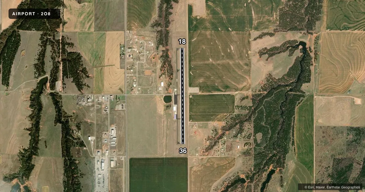
Airport sketch
Runways drawn to scale from FAA survey coordinates, rendered over satellite imagery. Not for navigation.
Approaches & charts
Services on the field
Fuel grades, oxygen, maintenance, ramp storage and lighting — as declared to the FAA by the airport operator.
Fuel & services
- Fuel
- 100LL
- Oxygen (bottled)
- Not available
- Oxygen (bulk)
- Not available
- Airframe repair
- Not available
- Power plant repair
- Not available
- Other services
- GLD
Ramp & ground
- Transient storage
- Tie-down
- Hangar
- Landing fee
- No fee published
- Lighting schedule
- SEE RMK
- Beacon schedule
- SS-SR
- Beacon
- White / Green (civil land)(WG)
- Wind indicator
- Lighted
- Segmented circle
- Yes
Fuel & FBOs
Cheapest 100LL and Jet A on the field and nearby. Always confirm with the FBO before taxi.
Airport notes
Surface conditions, obstructions, local procedures, lighting outages and other notes published with each FAA cycle.
General notes
- GLIDER ACT ON & INVOF ARPT.
- FOR CD CTC FORT WORTH ARTCC AT 817-858-7584.
Lighting notes
- PAPI RWY 18 & 36 ON CONSLY, PRESET LOW INTST AT NGT. INCR INTST 5 OR 7 MIC CLICKS - CTAF; MIRL RWY 18/36 SS-SR PRESET LOW INTST. INCR INTST 5 OR 7 MIC CLICKS - CTAF.
Fuel notes
- 100LLAVBL 24 HR WITH ADP SYS.
Other notes
- 30 FT PLINE EAST & PARL TO RWY CNTRLN HAS BEEN REMOVED, RELCTD, OR BURIED.
VFR map & nearby airports
VFR sectional. Tap any ICAO chip to open that airport.
Key facts · 2O8
Answer card- ICAO
- 2O8
- Name
- HINTON MUNI
- Location
- HINTON, OKLAHOMA
- Elevation
- 1,587 ft MSL
- Traffic pattern altitude
- 2,587 ft MSL (1,000 AGL)
- Control tower
- Non-towered (use CTAF)
- Total runways
- 1
- Longest runway
- 18/36 · 4,001 ft
- Published ILS approaches
- 0
- Published frequencies
- 2
- Magnetic variation
- 4°
- Current flight rules
- VFR
- Current wind
- 200° at 8 kt
- Favored runway now
- RWY 18
Hinton Muni sits in Hinton, Oklahoma. Field elevation is 1,587 ft MSL. The airport has one runway, 18/36, at 4,001 ft asphalt. There is no control tower. CTAF and UNICOM are both 123.05. No ILS approaches are published here.
Pattern altitude is not published. Use the standard 1,000 ft AGL pattern unless the current Chart Supplement says otherwise. That puts the light piston pattern at about 2,587 ft MSL based on the field elevation. For clearance delivery, Fort Worth ARTCC is listed at 817-858-7584. Glider activity is on and near the airport, so keep a sharp scan in the pattern and on departure.
The on-field FBO is Hinton Airport. It carries 100LL. 100LL is available 24 hours with an automatic dispensing system. The runway lighting is set up for night use. PAPI on 18 and 36 runs continuously and is preset to low intensity at night. Medium intensity runway lights on 18 and 36 operate from sunset to sunrise. You can increase intensity with 5 or 7 mic clicks on CTAF. A 30-foot power line east and parallel to the runway centerline has been removed, relocated, or buried. That helps the east side of the field, but it is still smart to verify current conditions before flying in.