METAR & TAF T60
T60 does not publish a METAR.
Showing the nearest reporting station: KSWW (AVENGER FLD) · 44.3 NM away. Conditions at T60 may differ.
METAR · KSWW
Observed 13:35Z
KSWW 271335Z AUTO 19011KT 10SM 27/20 A3003 RMK AO2 T02670197
- Wind
- 190° @ 11 kt
- Visibility
- 10 SM
- Temp / Dew
- 27°C / 20°C
- Altimeter
- 30.03 inHg
- Clouds
- Clear
- Density alt
- 3,466 ft
- Ceiling
- Unlimited
- Rules
- VFR
Airport info & contacts
Manager on record, flight service, ARTCC, attendance schedule and pattern altitude — published by the FAA and refreshed every 28 days.
Location
- From city
- 1 NM NE
- VFR sectional
- DALLAS-FT WORTH
- ARTCC
- ZFW · FORT WORTH
- NOTAM facility
- FTW (NOTAM-D)
Airport manager
- Name
- RONNIE MOORHEAD
- Phone
- 940-989-3393
- Address
- 128 TOWN SQUARE LANE, PO BOX 366, ASPERMONT TX 79502
Flight service · Hours
- FSS FTW
- FORT WORTH1-800-WX-BRIEF
- Attendance
- Unattended
Frequencies
Tap any row to copy the frequency to your clipboard.
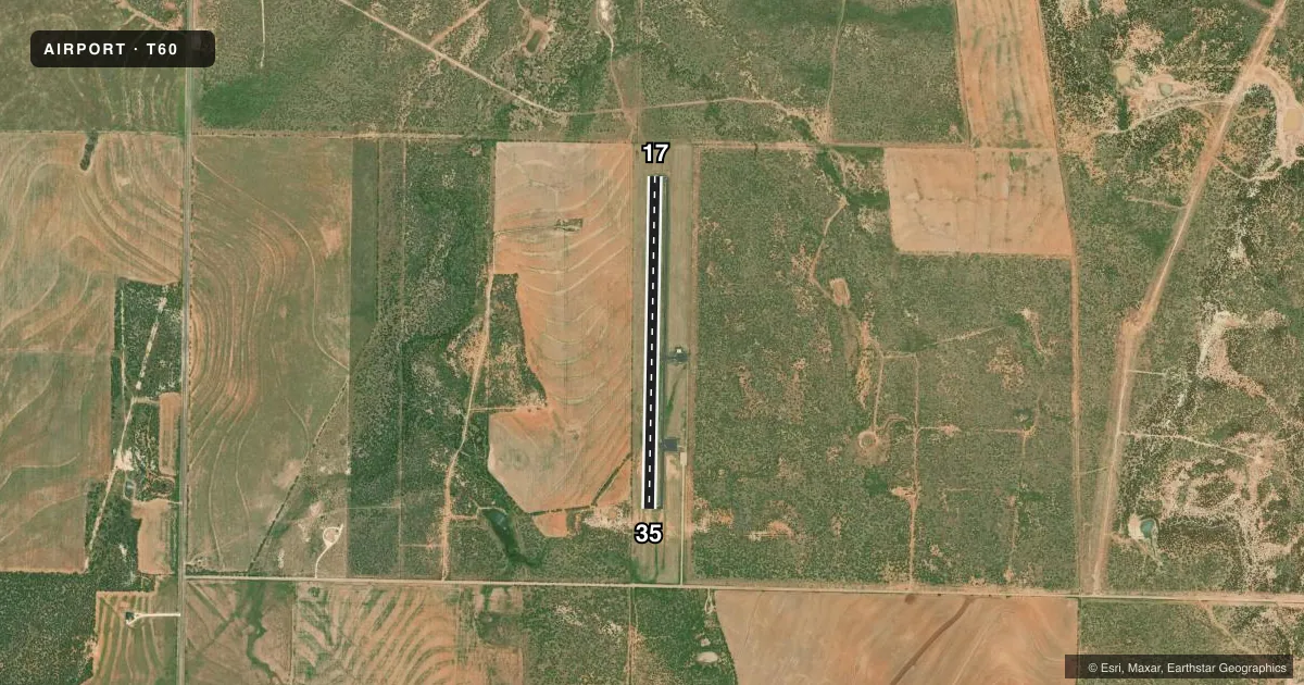
Runways & pattern
Full pagePattern entry · RWY 17
LEFT TRAFFICRunway end performance
| End | TORA | TODA | ASDA | LDA | VGSI | Approach lights | Obstruction |
|---|---|---|---|---|---|---|---|
| 35 | — | — | — | — | — | — | 20', pline, 895' from thr, 0' R of cntrln, slope 34 |
Declared distances in feet. TORA = takeoff run available, TODA = takeoff distance, ASDA = accelerate-stop, LDA = landing distance.
Airport sketch
Runways drawn to scale from FAA survey coordinates, rendered over satellite imagery. Not for navigation.
Approaches & charts
Services on the field
Fuel grades, oxygen, maintenance, ramp storage and lighting — as declared to the FAA by the airport operator.
Fuel & services
- Fuel
- Not available
Ramp & ground
- Transient storage
- Tie-down
- Lighting schedule
- SS-SR
- Beacon schedule
- SS-SR
- Beacon
- White / Green (civil land)(WG)
- Wind indicator
- Lighted
- Segmented circle
- Yes
Fuel & FBOs
Cheapest 100LL and Jet A on the field and nearby. Always confirm with the FBO before taxi.
Airport notes
Surface conditions, obstructions, local procedures, lighting outages and other notes published with each FAA cycle.
General notes
- GATE LOCKED. CALL AMGR FOR COMBINATION OR ACCESS.
- AGRICULTURAL ACTIVITY MAY-SEP.
- FOR CD CTC FORT WORTH ARTCC AT 817-858-7584.
- 940-200-0894 AMGR CELL.
Other notes
- MANAGERCO. JUDGE/AMGR.
- MANAGEREMERGENCY PHONE: 940-989-3333 (CENTRAL DISPATCH).
VFR map & nearby airports
VFR sectional. Tap any ICAO chip to open that airport.
Key facts · T60
Answer card- ICAO
- T60
- Name
- STONEWALL COUNTY
- Location
- ASPERMONT, TEXAS
- Elevation
- 1,744 ft MSL
- Traffic pattern altitude
- 2,744 ft MSL (1,000 AGL)
- Control tower
- Non-towered (use CTAF)
- Total runways
- 1
- Longest runway
- 17/35 · 4,000 ft
- Published ILS approaches
- 0
- Published frequencies
- 1
- Magnetic variation
- 8°
- Current flight rules
- VFR
- Current wind
- 190° at 11 kt
- Favored runway now
- RWY 17
Stonewall County Airport sits near Aspermont, Texas. The field elevation is 1,744 ft MSL. It has one runway, 17/35 and the longest runway is 4,000 ft of asphalt. The airport is not towered. CTAF is 122.9. No ILS approaches are published here.
Pattern altitude is not published in the facts. Use the current FAA Chart Supplement before you fly in. The airport manager is listed as the county judge and airport manager. The gate is locked, so call ahead for the combination or access. The airport manager cell number is 940-200-0894. For clearance delivery, Fort Worth ARTCC can be reached at 817-858-7584. Agricultural activity occurs from May through September. Expect low-level traffic and field work near the airport during that season.
There are no on-field FBOs listed in the facts. Check with the airport operator or call the field directly for current services before arrival. With a 1,744 ft elevation and no published ILS, plan your arrival with the current charted procedures and local weather in mind. If you need a pattern altitude or any noise or access details, verify them in the current FAA Chart Supplement before departure.